- Curbridge, Oxfordshire
-
Coordinates: 51°46′41″N 1°31′23″W / 51.778°N 1.523°W
Curbridge 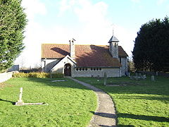
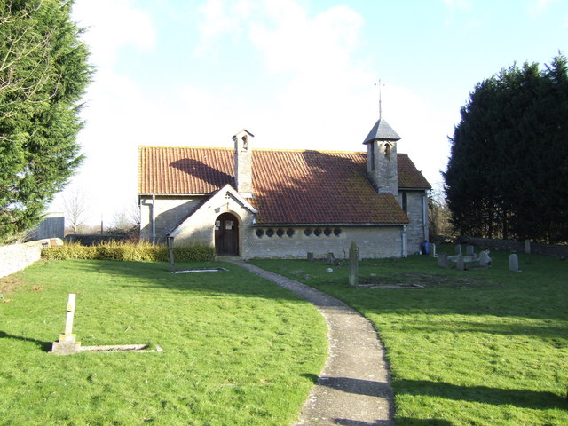
Parish church of Saint John the Baptist
 Curbridge
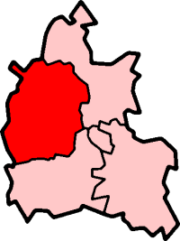
Curbridge shown within OxfordshirePopulation 425 (2001 census)[1] OS grid reference SP3308 Parish Curbridge District West Oxfordshire Shire county Oxfordshire Region South East Country England Sovereign state United Kingdom Post town Witney Postcode district OX29 Dialling code 01993 Police Thames Valley Fire Oxfordshire Ambulance South Central EU Parliament South East England UK Parliament Witney Website Curbridge website List of places: UK • England • Oxfordshire Curbridge is a village and civil parish immediately southwest of Witney, Oxfordshire.
Caswell Farm, 0.75 miles (1.21 km) southwest of the village, is a moated farmstead that includes remnants of a 15th century house.[2]
A Church of England chapel was built in Curbridge in 1838[2] and the Gothic Revival architect C.C. Rolfe added an apse in 1874.[3] In 1906 the chapel was demolished and replaced with the present Church of England parish church of Saint John the Baptist.[2]
References
- ^ "Area selected: West Oxfordshire (Non-Metropolitan District)". Neighbourhood Statistics: Full Dataset View. Office for National Statistics. http://neighbourhood.statistics.gov.uk/dissemination/viewFullDataset.do;jsessionid=ac1f930b30d73ec370d62b6f4444bc01a4cf1c94ffa8?instanceSelection=03070&productId=779&$ph=60_61&datasetInstanceId=3070&startColumn=1&numberOfColumns=8&containerAreaId=790500&nsjs=true&nsck=true&nssvg=true&nswid=1020. Retrieved 24 March 2010.
- ^ a b c Sherwood & Pevsner, 1974, page 567
- ^ Saint, 1970
Sources & further reading
- Saint, Andrew (1970). "Three Oxford Architects". Oxonensia (Oxfordshire Architectural and Historical Society) XXXV: 53 ff.. http://www.oahs.org.uk/oxo/vol%2035/Saint.doc. Retrieved 3 November 2009.
- Sherwood, Jennifer; Pevsner, Nikolaus (1974). Oxfordshire. The Buildings of England. Harmondsworth: Penguin Books. pp. 567. ISBN 0 14 071045 0.
- Townley, Simon C. (ed.); Baggs, A.P.; Chance, Eleanor; Colvin, Christina; Cooper, Janet (2004). A History of the County of Oxford, Volume 14: Bampton Hundred (Part Two). Victoria County History. pp. 190–225.
External links
 Media related to Curbridge, Oxfordshire at Wikimedia Commons
Oxfordshire • County Council elections • District Council elections • Witney County Constituency Towns Burford (Signet, Upton) • Carterton • Charlbury • Chipping Norton (Southcombe) • Witney (Cogges, Madley Park) • Woodstock (Hensington, Old Woodstock)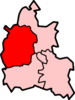
Large Villages Aston, Cote, Shifford and Chimney (Aston, Cote, Shifford, Chimney) • Bampton (Lower Haddon, Weald) • Brize Norton • Ducklington • Enstone (Church Enstone, Neat Enstone, Chalford, Cleveley, Fulwell, Gagingwell, Lidstone, Radford) • Eynsham (Barnard Gate) • Freeland • Hailey (New Yatt) • Hanborough (Church Hanborough, Long Hanborough) • Milton-under-Wychwood • Minster Lovell • North Leigh (East End, Wilcote) • Shipton-under-Wychwood • Standlake (Brighthampton) • Steeple Barton (Middle Barton) • StonesfieldOther Civil
Parishes
(Component
Villages
and Hamlets)Alvescot • Ascott-under-Wychwood (Ascott d'Oyley, Ascott Earl) • Asthall (Asthall Leigh, Worsham) • Black Bourton • Bladon • Blenheim • Broadwell • Bruern • Cassington (Worton) • Chadlington • Chastleton • Chilson (Shorthampton) • Churchill • Clanfield • Combe • Cornbury and Wychwood (Cornbury, Wychwood) • Cornwell • Crawley • Curbridge • Fawler • Fifield • Filkins and Broughton Poggs (Filkins, Broughton Poggs) • Finstock • Fulbrook • Glympton • Grafton and Radcot (Grafton, Radcot) • Great Tew • Hardwick-with-Yelford (Hardwick, Yelford) • Heythrop (Dunthrop) • Holwell • Idbury (Bould, Foscot) • Kelmscott • Kencot • Kiddington with Asterleigh (Asterleigh, Kiddington, Over Kiddington) • Kingham • Langford • Leafield • Lew • Little Faringdon • Little Tew • Lyneham • Northmoor • Over Norton • Ramsden (Mount Skippett) • Rollright (Great Rollright, Little Rollright) • Rousham • Salford • Sandford St. Martin (Ledwell) • Sarsden • Shilton • South Leigh • Spelsbury (Dean, Taston) • Stanton Harcourt • Swerford • Swinbrook and Widford (Swinbrook, Widford) • Tackley • Taynton • Westcott Barton • Westwell • Wootton (Dornford, Hordley) • Worton (Nether Worton, Over Worton)Former Districts
and BoroughsChipping Norton Rural District • Municipal Borough of Chipping Norton • Witney Urban District • Witney Rural District • Municipal Borough of Woodstock • Woodstock Rural DistrictFormer
ConstituenciesList of Parliamentary constituencies in Oxfordshire • List of places in Oxfordshire • List of civil parishes in Oxfordshire Categories:- Oxfordshire geography stubs
- Villages in Oxfordshire
- Civil parishes in Oxfordshire
- West Oxfordshire

Wikimedia Foundation. 2010.