- San Mateo Creek (Southern California)
-
For the creek in San Mateo County, California, see San Mateo Creek (San Francisco Bay Area).
San Mateo Creek[1] Arroyo de San Mateo[1], Rio San Mateo[1] River  San Mateo Creek Lagoon at the mouth
Country United States State California Regions San Diego County, Orange County District Marine Corps Base Camp Pendleton Tributaries - left Tenaja Canyon - right Cristianitos Canyon Source - location Santa Ana Mountains, Cleveland National Forest - coordinates 33°29′04″N 117°22′05″W / 33.48444°N 117.36806°W Mouth San Onofre State Beach - location Pacific Ocean - elevation 0 ft (0 m) - coordinates 33°23′05″N 117°35′34″W / 33.38472°N 117.59278°W Length 22 mi (35 km) Basin 139 sq mi (360 km2) Discharge for San Clemente - average 12.1 cu ft/s (0 m3/s) [2] - max 12,500 cu ft/s (354 m3/s) - min 0 cu ft/s (0 m3/s) 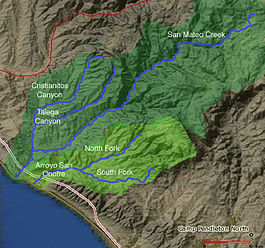 Map of San Mateo Creek and Arroyo San Onofre drainage basins. San Mateo Creek basin is in dark green.
San Mateo Creek is a stream in Southern California in the United States, whose watershed mostly straddles the border of Orange and San Diego Counties.[1] It is about 22 miles (35 km) long, flowing in a generally southwesterly direction. Draining a broad valley bounded by the Santa Ana Mountains and Santa Margarita Mountains, San Mateo Creek is notable for being one of the last unchannelized streams in Southern California.[3]
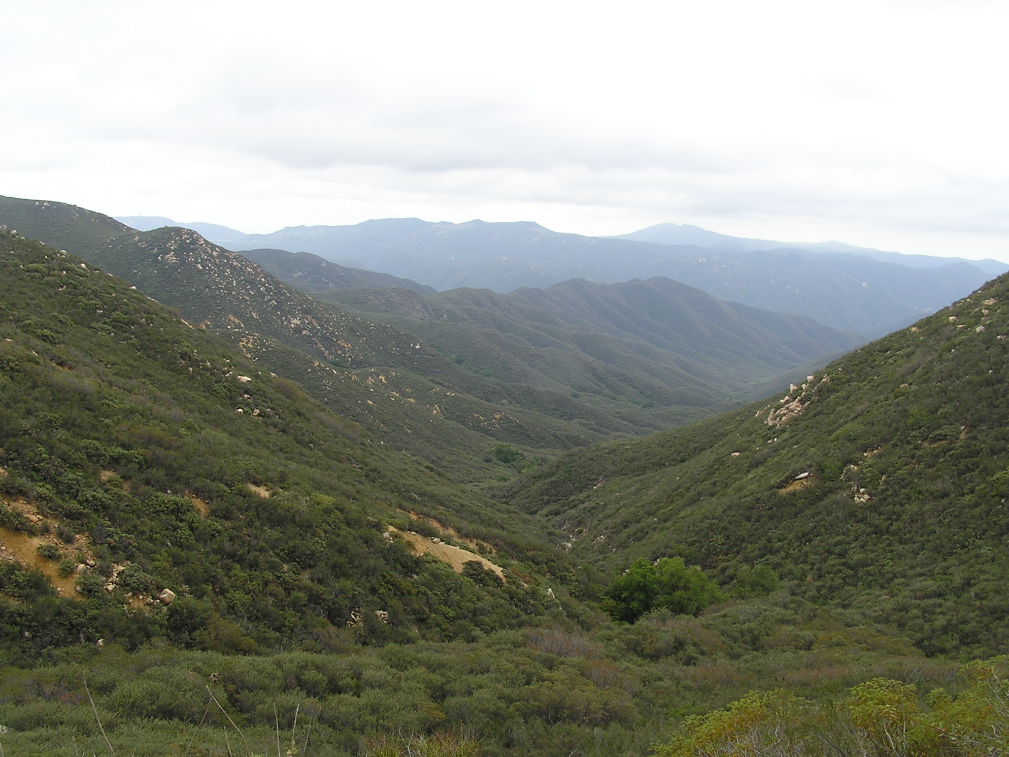
One of the most undeveloped watersheds on the South Coast, San Mateo Creek's drainage basin covers 139 square miles (360 km2) in parts of the Cleveland National Forest and Marine Corps Base Camp Pendleton. The first inhabitants were Native Americans primarily of the Luiseño group, followed by the Spanish who established ranchos in the area. The creek's usually perennial flow made it an important source of irrigation water, then in the later 19th century, there was a gold rush in the upper watershed. Most of the little development in the watershed is now agriculture-based.
The San Mateo Creek watershed includes the subwatersheds of Talega, Tenaja, Gabino and Cristianitos Canyon. Although grazing activities have hurt the biological quality of the semi-arid, Mediterranean-climate watershed, it still supports numerous biological communities including riparian zones, grassland and coastal sage scrub. A population of steelhead trout has recently been identified in the creek, which is slightly affected by minor agricultural runoff.
Contents
Course
The 22-mile (35 km)-long San Mateo Creek begins its course in an isolated canyon in the extreme southeastern end of the Santa Ana Mountains, which lie mostly in Orange County. From there, the creek continues through a steep and narrow gorge for the first part of its course, then a broad and shallower valley for the second part. It receives four major tributaries and many smaller ones on its generally southwest journey to the Pacific Ocean.[4]
From its headwaters near Lake Elsinore inside the Cleveland National Forest, San Mateo Creek runs southwards through a canyon that widens and deepens until it is roughly 600 feet (180 m) in depth. It then turns southwest, cutting between the Santa Ana and Santa Margarita Mountains in an arid canyon surrounded by slopes dissected by many side canyons. At river mile (RM) 18 or river kilometer (RK) 28.9, Tenaja Creek, which flows generally northwest, comes in from the left. Shortly after, at RM 17.5 (RK 28.1) Bluewater Canyon merges with San Mateo Canyon from the right.[4]
The creek then continues to flow southwards and Cold Spring Creek comes in from the left at RM 15 (RK 24.1). The Cold Spring Creek confluence approximately marks the point where San Mateo Creek leaves the Cleveland National Forest. Soon, the narrow 2,500-foot (760 m)-deep canyon gives way to a broad alluvial valley. San Mateo Creek flows past Camp Pendleton, a United States Marine Corps amphibious training base. At RM 3.7 (RK 5.95) Cristianitos Canyon, the largest tributary, joins from the right. Cristianitos Canyon begins in extreme southeastern Orange County and drains about 29 square miles (75 km2).[4]
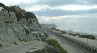
San Mateo Creek then crosses under Interstate 5 and empties into a small, perennial freshwater lagoon bounded by a sandbar at San Onofre State Beach. The lagoon only empties into the sea during the rainy season. This portion of the creek is very close to San Clemente and a small residential area is just to the northeast side of the lagoon. The lagoon remains similar to its natural state as well, although it is increasingly becoming harmed by unnatural pollutants.[5]
Geologic history
Geologically the San Mateo Creek watershed is dominated by the Santa Ana Mountains, whose underlying bedrock consists of Jurassic-age igneous and sedimentary rock, overlain by a few thousand vertical feet of Cretaceous-age granite, gabbro, and tolamite. Underneath the San Mateo Creek valley's several hundred feet of alluvial deposits, there are layers of sandstone, limestone, siltstone, mudstone, shale and conglomerate. These formations are present along most of the streams draining off the west slope of the Santa Ana Mountains and are practically identical as far north as Santiago Creek, which is in north-central Orange County nearly 50 miles (80 km) away.[4][6]
The alluvial deposits originate from the Wisconsinian glaciation, in which massive glaciers and ice sheets advanced over much of North America and shifted the global climate. During this roughly 60,000 year long period that ended in approximately 8000 B.C., Southern California received up to 80 inches (2,000 mm) of rainfall per year, and this radical climate change coincided with a 300-to-400-foot (91 to 120 m) drop in sea level. As the sea levels fell, streams flowing into the Pacific from Southern California began to erode massive canyons in their floodplains.[7]
The rivers eventually eroded to 400 feet (120 m) or so below their previous elevation. When the Wisconsinian period ended, sea level rose, filled these canyons and turned them into long, narrow inlets. Because the heavy rains ceased with the departure of the Wisconsinian, the rivers and streams once again became slow-flowing. Over the course of thousands of years, these calm inlets gradually filled with alluvial sediments, giving them the flat valley floors they have today. Over time, sea level dropped slightly again, allowing the rivers to once again entrench channels into their floodplains, resulting in the broad river terraces that line much of lower San Mateo Creek, Arroyo San Onofre and San Juan Creek.[8]
Soils
Most of the soils in the San Mateo Creek drainage area are loamy, well-drained and also fertile in the lowlands. In the mountains the soil cover is very shallow and there are many exposed cliffs, large boulders and outcroppings of sedimentary rock.[4] In the lower watershed are sandy or silty loams which have a clay substructure. These soils are classified as highly fertile and there are a few farms on the foothills and the floodplain of the San Mateo Creek watershed.[4]
Watershed
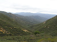 San Mateo Canyon Wilderness in the northwest upper basin
The San Mateo Creek drainage basin covers 139 square miles (360 km2) mostly in San Diego County and partially in Orange County.[9] It shares boundaries with several watersheds—including Segunda Deshecha Cañada to the west, Arroyo San Onofre to the southeast, and streams draining into Lake Elsinore in the northeast. It is slightly larger than the 133.9-square-mile (347 km2) San Juan Creek watershed,[10] which borders on the San Mateo Creek watershed's northeastern side.
The upper reaches of the watershed consist primarily of canyons that are 200 to 2,500 feet (61 to 760 m) deep and 0.5 to 1 mile (0.80 to 1.6 km) broad, while the lower watershed is a valley 2.5 to 3 miles (4.0 to 4.8 km) wide and less than 1,000 feet (300 m) deep. The largest tributary of San Mateo Creek is Cristianitos Canyon (or Christianitos Canyon), which is about 10 miles (16 km) long and drains 29 square miles (75 km2) in the western portion of the watershed with a portion in Orange County. Other significant sub-basins in the watershed include Talega Canyon, La Paz Creek and Gabino Creek, all of which are tributaries of Cristianitos Canyon.[4]
The Santa Ana Mountains form the drainage divide with San Juan Creek on the northwest side of the San Mateo Creek valley, and the Santa Margarita Mountains on the southeast separate San Mateo Creek from the Arroyo San Onofre, a creek that drains westwards to the Pacific Ocean. Arroyo San Onofre is also the closest major stream to San Mateo Creek by location of the mouth. The next closest is Segunda Deshecha Cañada, further north. Much of the upper San Mateo Creek watershed is encompassed by the central Cleveland National Forest and the lower lies mostly within Camp Pendleton. The closest city is San Clemente, northwest of the creek's mouth.[4]
San Mateo Creek was once a seasonal stream that would flow through the rainy season, run dry by June or July and restart in October. Although springs exist in the mountains, once the creek spilled onto its floodplain, it would seep into the ground and run in a subsurface manner. Irrigation return flows and a sewage treatment plant have increased its flows to perennial, although it does not receive as much runoff as most other Southern California streams. The typical annual peak flow is around 2,760 cubic feet per second (78 m3/s), while the 2-year flood is 3,200 cubic feet per second (91 m3/s), the 10-year event, 19,160 cubic feet per second (543 m3/s), and the 100-year flood, 47,530 cubic feet per second (1,346 m3/s).[4]
Ecology
Plants
Supporting a highly productive ecosystem, the San Mateo Creek watershed includes a high variety of elevations and vegetation groups. These include riparian zones and woodlands around the perennial or semi-perennial streams, grassland on the valley floors, and chaparral and coastal sage scrub on the hillsides. Overall the vegetation groups and their distribution are very similar to that of San Juan Creek and its major tributary, Trabuco Creek, in the northwest. The major difference is that the San Mateo Creek watershed contains no major residential areas.
The mouth of the creek and its last reaches shortly above and below Camp Pendleton are host to a wide variety of riparian plants. At the mouth, there is a freshwater lagoon and several freshwater marshes, surrounded by a riparian woodland consisting primarily of willow, sycamore, live oak and cottonwood.[9] Surrounding the lower San Mateo Creek valley and on the shallow slopes is the coastal sage scrub community, which consist primarily of coast goldenbush, coyote brush, California sagebrush, mulefat, toyon, poison oak, laurel sumac, California mugwort, Mexican elderberry, and California encelia. At the very mouth, where groundwater surfaces on the streambed, there are the stands of trees, and undergrowth includes wild cucumber and gooseberry.[11]
Freshwater marshes surrounding San Mateo Creek exist in a strip just a few hundred feet wide and draw their water supply primarily from emerging groundwater. The most prominent plants are bulrush[disambiguation needed
 ], specifically California bulrush, and cattail. There are also several species of burweeds and ferns, and on the edges of the marshes and on the surrounding small meadows, goldenrod, hedge-nettle, fleshy jaumea, Mexican rush, saltgrass, and iceplant.[11]
Animals
In February, 1999 Southern Steelhead Trout (Oncorhyncus mykiss) were discovered in the creek by Toby Shackelford, making San Mateo Creek the only watercourse south of Malibu Creek in Los Angeles County to host this endanged species.[12] Steelhead have historically spawned in the creek, whose upper reaches also support a population of rainbow trout, the form taken by Oncorhyncus mykiss when it remains land-locked. There are about 11 miles (18 km) of streams in the watershed that provide suitable habitat for steelhead trout.[13] Significantly, DNA analysis has shown that San Mateo Creek steelhead are genetically native southern steelhead, and not hatchery stocked fish. Steelhead in San Mateo Creek spawn primarily in the winter, when heavy storm runoff from the Santa Ana and Santa Margarita Mountains raises the creek's flow enough to breach the sandbar at San Onofre State Park. In the few weeks or months following when there is still a substantial flow in the creek, the steelhead spawn and then the adults return to sea. In the dry months following the streams in the lowlands shrink to small pools that still support amphibians and small fish including steelhead fry which need to spend about one year in freshwater.[13] Recently, steelhead have been sighted in the creek in greater numbers, bringing attention to coastal San Diego and Orange County streams.[14]
Other fish and amphibian species in the watershed include the endangered tidewater goby and arroyo toad. Tidewater goby reside in small to medium-sized, brackish sloughs and marshes near the mouth of the creek. The watershed also has a number of birds; endangered species include the Least Bell's Vireo (Vireo bellii pusillus), California Gnatcatcher (Polioptila californica) and Willow Flycatcher (Empidonax traillii).[13]
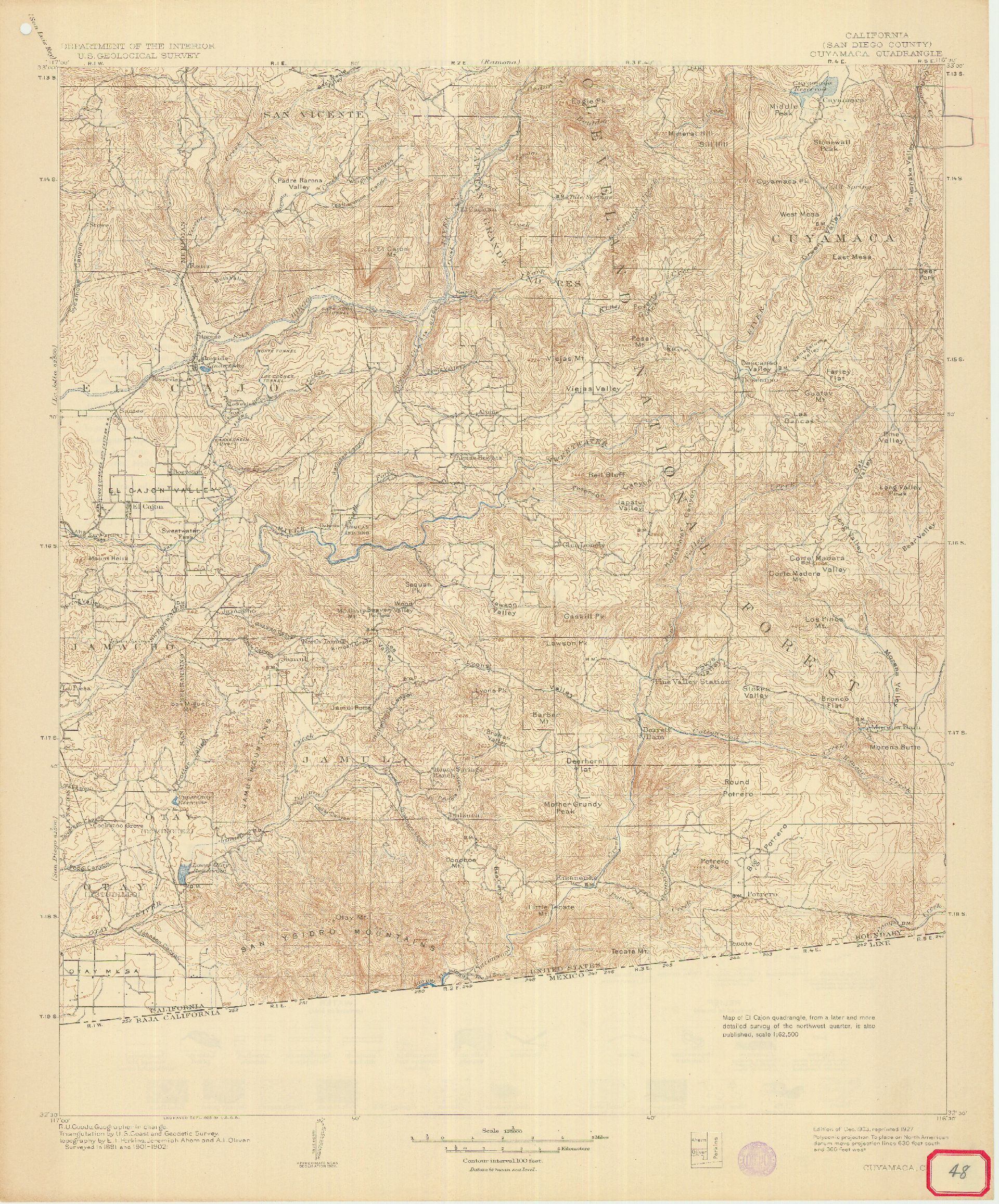
In early February, 2010 a Golden beaver (Castor canadensis subauratus) was captured in a live trap by San Onofre State Beach officers who discovered the beaver at the river mouth of San Mateo Creek. According to State Parks officials, the species was once native to the San Mateo Creek watershed, but were thought to be extinct.[15] Beaver were also found in an ecological survey of the lagoon near the creek mouth in 1987.[16] A report on the fauna of the county by Dr. David Hoffman in 1866 stated "Of the animal kingdom we have a fair variety: the grizzly bear, the antelope, the deer, the polecat, the beaver, the wildcat, the otter, the fox, the badger, the hare, the squirrel, and coyotes innumerable."[17] The beaver may have accessed San Mateo Creek from the Santa Margarita River watershed where Golden beaver were re-introduced around 1940.[18] Indirect evidence of beaver in San Diego County includes a creek named Beaver Hollow which runs 3.25 miles into the Sweetwater River about 6.5 miles southwest of Alpine.[19][20] Beaver Hollow is named on the USGS Topo Map for Cuyamaca in 1903, which is twenty years before California Department of Fish and Game began beaver re-introductions in California.[21]
History
Evidence suggests that Native Americans have inhabited the San Mateo Creek watershed for at least 8,000 years.[9] One of the largest villages was Panhe, an Acjachemen Indian village located at the confluence of San Mateo Creek and Cristianitos Canyon, approximately 3.7 miles (6.0 km) upstream from the Pacific Ocean.[4][9] The Native Americans fished in San Mateo Creek's extensive freshwater marshes, and practiced a hunter-gatherer lifestyle. Other Native American groups in the area included the Kumeyaay, Luiseño, Cahuella, and Capeño. The village of Panhe is estimated to have had a population of 300 or so before the first Spanish explorers came to the area, and is still a sacred site for the Native Americans.[22]
 San Mateo Creek mouth at San Onofre State Beach
The first Spanish explorers to have seen the creek were likely part ot the Gaspar de Portolá expedition of 1769 to Monterey Bay, whose members crossed the creek near its mouth on July 22 or 23.[23] This group was responsible for giving the first European names to many of the creeks and canyons in the area, including San Juan Creek, Santiago Creek, and Arroyo San Onofre, many of which stayed. After the construction of Mission San Juan Capistrano near the present-day site of the city of the same name, the San Mateo Creek Valley was settled by the Spanish and extensively farmed and irrigated. These practices hurt the groundwater and hydrology of the area, which is slowly recovering.[23]
By 1833, the Secularization Act passed by the newly independent country of Mexico brought an end to the mission period.[23] Thousands of acres of land once owned by the missions now had no owners, so the land was split into large ranchos. The 133,441-acre (540.02 km2) Rancho Santa Margarita y Las Flores was established in 1841 and granted to Pio and Andres Pico. They planted non-native crops, pumped water from the aquifer, and grazed cattle, severely damaging the grasslands and riparian habitat. By 1860, a discovery of gold, zinc, lead and silver in the upper San Mateo Creek watershed led American miners to the area.[23] The rancho went through many hands and there were many conflicts with Native Americans before the U.S. Navy, in 1941, purchased most of the land for Camp Pendleton for around $6.5 million.[24]
Recently a controversy has erupted over whether to extend California State Route 241 south through the lower San Mateo Creek valley to join Interstate 5 near the creek's mouth. The project was proposed to improve traffic flow on the Orange-San Diego County border. While proponents of the project claim that it will relieve congestion on the interstate and not affect the native habitat,[25] opponents argue that the routing would increase sediment loads in the creek, damage the surf break at San Onofre State Beach, create water pollution and hurt several endangered animal species.[26] The project prompted American Rivers to list San Mateo Creek as the "nation's second-most imperiled waterway".[27] No decision has been made on the project to date.
References
- ^ a b c d "San Mateo Creek". Geographic Names Information System, U.S. Geological Survey. 19 January 1981. http://geonames.usgs.gov/pls/gnispublic/f?p=gnispq:3:::NO::P3_FID:248921. Retrieved 2009-09-20.
- ^ "Water-Data Report 2009: USGS Gage #11046300 on San Mateo Creek near San Clemente, CA". National Water Information System. U.S. Geologic Survey. 1952-2009. http://wdr.water.usgs.gov/wy2009/pdfs/11046300.2009.pdf. Retrieved 2010-09-13.
- ^ "Steelhead in San Mateo Creek!". Sierra Club Southern California/Nevada Field Office. Sierra Club. http://www.sierraclub.org/field/southerncal/steelhead.asp. Retrieved 2009-09-19.
- ^ a b c d e f g h i j "San Mateo Creek Watershed Profile". Southern California Wetlands Recovery Project. wrpinfo.scc.ca.gov. http://wrpinfo.scc.ca.gov/watersheds/sm/sm_profile.html. Retrieved 2009-09-19.
- ^ Brennan, Pat (February 5, 2009). "Modern world presses in on San Mateo Creek lagoon". OC Register. http://www.ocregister.com/articles/species-creek-native-2299493-pryor-toll. Retrieved 2009-09-19.
- ^ "Santa Ana River Watershed Geology". Santa Ana Watershed Project Authority. www.sawpa.org. http://www.sawpa.org/watershedinfo.html. Retrieved 2009-09-12.
- ^ Waters, Machael R.; Byrd, Brian F.; Reddy, Seetha N. (15 October 1998). "Geoarchaeological investigations of San Mateo and Las Flores Creeks, California: Implications for coastal settlement models". Geoarchaeology 14 (3).
- ^ Colburn, Ivan. "The Role of Antecedent Rivers in Shaping the Orange/Los Angeles Coastal Plain". California State University Los Angeles Department of Geology. www.calstatela.edu. http://www.calstatela.edu/dept/geology/ColburnRivers.pdf. Retrieved 2009-09-20.
- ^ a b c d "San Mateo Creek: An Overview". San Mateo Creek Conservancy. sanmateocc.org. http://sanmateocc.org/files/SanMateoCreekOverview.pdf. Retrieved 2009-09-20.
- ^ "Introduction to San Juan Creek Watershed". Watershed and Coastal Resources Division of Orange County. www.ocwatersheds.com. http://www.ocwatersheds.com/watersheds/sanjuan.asp. Retrieved 2009-09-20.
- ^ a b "Trestles Wetlands Natural Preserve Plant Communities". San Mateo Creek Conservancy. sanmateocc.org. http://sanmateocc.org/files/TWNPPlantCommunities.pdf. Retrieved 2009-09-20.
- ^ Ed Leibowitz (1999-10-03). "Saving the Steelhead". Los Angeles Times. http://articles.latimes.com/1999/oct/03/magazine/tm-17980. Retrieved 2010-07-03.
- ^ a b c "San Mateo Creek Enhancement Plan". San Diego Trout. http://www.sandiegotrout.org/plan.htm. Retrieved 2009-09-20.
- ^ "The Major Watersheds of the South Coast". Ocean Coastal Policy Center, Marine Science Institute. ocpc.msi.ucsb.edu. http://ocpc.msi.ucsb.edu/pdfs/WT4/2pp23-27.pdf. Retrieved 2009-09-20.
- ^ Alexis Henry (2010-02-05). "Trestles can now add 'beavers' to list of special things". Surfers Village Global Surf News. http://www.surfersvillage.com/surfing/45297/news.htm. Retrieved 2010-07-03.
- ^ Trestles Wetlands Natural Preserve Habitat Restoration Plan (Report). San Mateo Creek Conservancy. April, 2009. p. 9. http://www.trestleswetlands.org/files/TrestlesWetlandsNaturalPreserveHabitatPreservation.pdf. Retrieved 2010-07-14.
- ^ Clifford L. Graves (July, 1964). "An Early San Diego Physician: David Hoffman". The Journal of San Diego History. https://www.sandiegohistory.org/journal/64july/hoffman.htm. Retrieved 2010-07-03.
- ^ Arthur L. Hensley (1946). "A Progress Report on Beaver Management in California". California Fish and Game, Vol. 32, No. 2: 88. http://ia351406.us.archive.org/0/items/californiafishga32_2cali/californiafishga32_2cali.pdf. Retrieved 2010-07-03.
- ^ U.S. Geological Survey Geographic Names Information System: Beaver Hollow
- ^ David L. Durham (2001-01). Durham's Place Names of San Diego County. Word Dancer Press. p. 5. ISBN 9781884995323. http://www.amazon.com/Durhams-County-Durham-California-Place-Names/dp/1884995322/ref=sr_1_3?s=books&ie=UTF8&qid=1296336557&sr=1-3. Retrieved 2011-01-28.
- ^ "Historical Topo Maps, San Diego County, Map Number 1". 1903-12. http://www.muststayawake.com/SDAG/JPG/Cuy-topo300.jpg. Retrieved 2011-02-08.
- ^ Donaldson, Milford Wayne (February 6, 2008). "Testimony regarding the Consistency Certification for the Foothill South Toll Road". ohv.parks.ca.gov. http://ohv.parks.ca.gov/pages/1066/files/mwd%20Testimony%20re%20Foothill%20Transportation%20Corridor.pdf. Retrieved 2009-09-20.
- ^ a b c d "San Mateo Creek Watershed Profile, History". Southern California Wetlands Conservation Project. San Mateo Creek Conservancy. http://sanmateocc.org/files/SANMATEOCREEKHISTORY.pdf. Retrieved 2009-09-20.
- ^ Herbert, Edgar W. (July 1961). "Las Flores". The Journal of San Diego History, Volume 7, No. 3. San Diego Historical Society. https://www.sandiegohistory.org/journal/61july/lasflores.htm. Retrieved 2009-09-20.
- ^ Margro, Tom (July 27, 2008). "ANOTHER VIEW: Transportation agency rebuts column". North County Times. http://www.nctimes.com/news/opinion/perspective/article_12ad92b0-f138-5707-9f46-5823047e1ad3.html. Retrieved 2009-09-20.
- ^ Lieu, Lynn (2008-01-24). "Coalition rises to protect San Onofre State Beach". Capitol Weekly. http://www.capitolweekly.net/article.php?xid=wuo1d5zlmtct2j. Retrieved 2009-09-20.
- ^ Rogers, Terry (April 18, 2007). "Perilous times for San Mateo Creek". Sign on San Diego. http://www.signonsandiego.com/news/northcounty/20070418-9999-1m18creek.html. Retrieved 2009-09-20.
External links
Categories:- Rivers of San Diego County, California
- Rivers of Orange County, California

Wikimedia Foundation. 2010.