- Mixbury
-
Coordinates: 52°00′14″N 1°06′50″W / 52.004°N 1.114°W
Mixbury 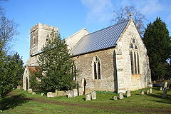
All Saints' parish church
 Mixbury
Mixbury shown within OxfordshirePopulation 255 (2001 census)[1] OS grid reference SP6033 Parish Mixbury District Cherwell Shire county Oxfordshire Region South East Country England Sovereign state United Kingdom Post town Brackley Postcode district NN13 Dialling code 01280 Police Thames Valley Fire Oxfordshire Ambulance South Central EU Parliament South East England UK Parliament Banbury List of places: UK • England • Oxfordshire Mixbury is a village and civil parish in Oxfordshire, about 2.5 miles (4 km) southeast of Brackley in Northamptonshire.
Contents
Manor
The toponym is derived from the Old English mixen-burgh,[2] meaning "fortification near dung-heap".[3] "Burgh" refers to Beaumont Castle, which was built about 1100. It no longer stands, but its earthworks remain at the north end of the village.[4][5]
The Domesday Book records that in 1086 Roger d'Ivry held a manor of 17 hides at Missberie.[2] The manor was part of the Honour of St. Valery by 1213, when Robert de St. Valery gave Mixbury's mesne lordship to the Augustinian Osney Abbey.[2] The abbey retained Mixbury until it was suppressed in the Dissolution of the monasteries in 1539.[2]
Parish church
The Church of England parish church of All Saints dates from the 12th century.[4] The south doorway is Norman, dating from about 1170.[4] Early in the 14th century[2] all the windows were replaced with Decorated Gothic ones.[4] A south aisle of three bays and a west tower were added at the same time.[2] The Perpendicular Gothic clerestorey was added later.[4] The chancel was restored in 1843 and the remainder of the church was restored after 1848.[2]
The bell tower has three bells.[6] The treble bell was cast in 1577 by John Appowell[7] of Buckingham,[8] the tenor in 1609 by Robert Atton[7] of Buckingham[8] and the second in 1627 by Bartholomew Atton[7] of Buckingham.[8] Ringing now is very restricted for safety reasons.[7]
The ecclesiastical parish is now a member of the Shelswell Benefice.[3]
Economic and social history
The main road between Buckingham and Banbury passes through the parish south of the village. It was made into a turnpike by an Act of Parliament in 1744.[2]
The rector had the village school built in 1838.[2] In 1928 it was reorganised as a junior school and older pupils were transferred to the school at Fringford.[2] It was reorganised as an infants' school in 1948 and closed in 1955.[2]
The original village consisted of thatch-roofed rubblestone cottages clustered between All Saints and the stream.[9] In 1874 they were demolished under an order of the Court of Chancery and replaced with two rows of brick-faced semi-detached estate cottages laid out as a model village along the road leading south from the church.[9]
In 1847-50 the Buckinghamshire Railway built its branch line to Banbury Merton Street through the northern part of the parish along the Great Ouse Valley. Fulwell & Westbury station was built on the line about 1 mile (1.6 km) northeast of the village. In 1899 the Great Central Railway built its main line to London through the eastern part of the parish and built Finmere for Buckingham station about 2 miles (3.2 km) miles southeast of the village.[2] Buckingham already had a railway station on the Buckinghamshire Railway and is almost 5 miles (8.0 km) from the Great Central station, so the name was subsequently shortened to the more appropriate "Finmere". British Railways closed Finmere station in 1963, and closed the section of the Great Central line through the station and parish in 1966. BR also closed Fulwell and Westbury station and the Buckinghamshire Railway line to Banbury in the 1960s.
References
- ^ "Area: Mixbury CP (Parish): Parish Headcounts". Neighbourhood Statistics. Office for National Statistics. http://neighbourhood.statistics.gov.uk/dissemination/LeadTableView.do?a=7&b=798586&c=Mixbury&d=16&e=15&g=480155&i=1001x1003x1004&o=1&m=0&r=1&s=1268091725031&enc=1&dsFamilyId=779. Retrieved 8 March 2010.
- ^ a b c d e f g h i j k l Lobel, 1959, pages 251-262
- ^ a b Shelswell group of Parishes: All Saints Church, Mixbury
- ^ a b c d e Sherwood & Pevsner, 1974, page 710
- ^ The Gatehouse website page for Beaumont Castle, Mixbury
- ^ Oxford Diocesan Guild of Church Bell Ringers, Bicester Branch: Mixbury
- ^ a b c d "Mixbury All Saints". Dove's Guide for Church Bell Ringers. http://dove.cccbr.org.uk/detail.php?DoveID=MIXBURY. Retrieved 10 June 2010.
- ^ a b c "Bell Founders". Dove's Guide for Church Bell Ringers. http://dove.cccbr.org.uk/founders.php. Retrieved 10 June 2010.
- ^ a b Rowley, 1978, pages 138-139
Sources
- Blomfield, James Charles (circa 1890). Part V: History of Fringford, Hethe, Mixbury, Newton Purcell, and Shelswell. Deanery of Bicester. Elliot Stock & Co: London.
- Lobel, Mary D, ed (1959). A History of the County of Oxford: Volume 6. Victoria County History. pp. 251–262.
- Rowley, Trevor (1978). Villages in the Landscape. Archaeology in the Field Series. London: J.M. Dent & Sons Ltd. pp. 138–139. ISBN 0 460 04166 5.
- Sherwood, Jennifer; Pevsner, Nikolaus (1974). The Buildings of England: Oxfordshire. Harmondsworth: Penguin Books. p. 710. ISBN 0 14 071045 0.
External links
 Media related to Mixbury at Wikimedia Commons
Towns 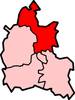
Large Villages Adderbury • Ambrosden • Arncott (Upper Arncott) • Bloxham • Bodicote • Caversfield • Deddington (Clifton, Hempton) • Hook Norton • Kidlington • Launton • Upper Heyford • YarntonOther Civil
Parishes
(Component
Villages
and Hamlets)Ardley with Fewcott (Ardley, Fewcott) • Barford St. John and St. Michael (Barford St. Michael, Barford St. John) • Begbroke • Blackthorn • Bletchingdon (Enslow) • Bourton (Great Bourton, Little Bourton) • Broughton • Bucknell • Charlton-on-Otmoor • Chesterton (Little Chesterton) • Claydon with Clattercot (Claydon, Clattercote) • Cottisford (Juniper Hill) • Cropredy • Drayton • Duns Tew • Epwell • Fencott and Murcott (Fencott, Murcott) • Finmere • Fringford • Fritwell • Godington • Gosford and Water Eaton (Gosford, Water Eaton) • Hampton Gay and Poyle (Hampton Gay, Hampton Poyle) • Hanwell • Hardwick with Tusmore (Hardwick, Tusmore) • Hethe (Willaston) • Horley • Hornton • Horton-cum-Studley • Islip • Kirtlington (Northbrook) • Lower Heyford (Caulcott) • Merton • Middle Aston • Middleton Stoney • Milcombe • Milton • Mixbury • Mollington • Newton Purcell with Shelswell (Newton Purcell, Shelswell) • Noke • North Aston • North Newington • Oddington • Piddington • Prescote • Shenington with Alkerton (Shenington, Alkerton) • Shipton-on-Cherwell and Thrupp (Shipton-on-Cherwell, Thrupp) • Shutford • Sibford Ferris • Sibford Gower (Burdrop) • Somerton • Souldern • South Newington • Steeple Aston • Stoke Lyne (Bainton) • Stratton Audley • Swalcliffe • Tadmarton • Wardington (Lower Wardington, Upper Wardington) • Wendlebury • Weston-on-the-Green • Wigginton • Wroxton (Balscote)Former Districts
and BoroughsMunicipal Borough of Banbury • Banbury Rural District • Bicester Urban District • Ploughley Rural District • Bicester Rural DistrictFormer
ConstituenciesCeremonial county of Oxfordshire Boroughs or districts Major settlements - Abingdon
- Banbury
- Bicester
- Burford
- Carterton
- Charlbury
- Chipping Norton
- Didcot
- Faringdon
- Henley-on-Thames
- Oxford
- Thame
- Wallingford
- Wantage
- Watlington
- Witney
- Woodstock
See also: List of civil parishes in Oxfordshire
Topics Categories:- Cherwell
- Villages in Oxfordshire
- Civil parishes in Oxfordshire


Wikimedia Foundation. 2010.