- Mount Holmes
-
Mount Holmes
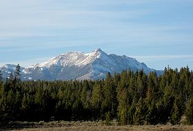
Mount HolmesElevation 10,331 ft (3,149 m) [1] Location Location Yellowstone National Park, Park County, Wyoming, USA Range Gallatin Range Coordinates 44°49′08″N 110°51′21″W / 44.81889°N 110.85583°WCoordinates: 44°49′08″N 110°51′21″W / 44.81889°N 110.85583°W[1] Topo map Mount Holmes Climbing Easiest route Hike Mount Holmes is a prominent mountain peak in Yellowstone National Park. It is the tallest mountain in the Wyoming portion of the Gallatin Range. Mount Holmes is located in the northwestern part of the park and marks the southern terminus of the Gallatin Range. It is the source of Indian Creek, a tributary of the Gardner River.
There is a ranger station near the top of Mount Holmes from which forest fires and weather are monitored. The Bannock Trail crosses the mountains close to Mount Holmes.
History
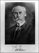
A 1860 map by Captain William F. Raynolds showed this peak as Mount Gallatin. Prior to 1878, the peak was routinely referred to as Mount Madison because of its proximity to the Madison River. In 1878 Henry Gannett and geologist William H. Holmes, members of the third Hayden Geologic Survey, ascended the peak. Gannett named the peak Mount Holmes[2].
The summit of Mount Holmes can be reached via the 10.8 miles (17.4 km) Mount Holmes-Winter Creek trail. The trailhead is located near Apollonaris Spring on the Mammoth-Norris section of the Grand Loop Road[3].
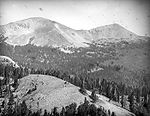
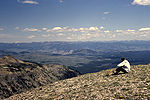
Images of Mount Holmes Mount Holmes' namesake, William H. HolmesMount Holmes as seen from Winter Creek, 1890Mount Holmes and other peaks, 1963Looking east from summit of Mount Holmes, 19652009See also
Notes
- ^ a b "Mount Holmes". Geographic Names Information System, U.S. Geological Survey. http://geonames.usgs.gov/pls/gnispublic/f?p=gnispq:3:::NO::P3_FID:1589642.
- ^ Whittlesey, Lee (1988). Yellowstone Place Names. Helena, MT: Montana Historical Society Press. pp. 105. ISBN 0917298152.
- ^ Schneider, Bill (2003). Hiking Yellowstone National Park. Guilford, CT: Falcon Press. pp. 129–131. ISBN 0762725397.
Geothermal features, historic structures and other attractions in the Norris and Madison Junction areasNorris Geyser Basin 
Gibbon Geyser Basin Structures and History Geography and Geology Echo Peak • Gibbon Falls • Gibbon River • Grebe Lake • Firehole Falls • Firehole River • Madison River • Mount Haynes • Mount Holmes • Mount Jackson • Purple Mountain • Virginia Cascades • West Yellowstone, MontanaList of Yellowstone National Park related articles
 Media related to Norris Geyser Basin at Wikimedia Commons
 State of Wyoming
Topics - Governors
- Delegations
- Geography
- Government
- History
- People
- Visitor Attractions
- State Symbols
- Radio Stations
Society - Crime
- Demographics
- Economy
- Education
- Politics
Regions Cities Counties Categories:- Mountains of Yellowstone
- Mountains of Wyoming
- Geography of Park County, Wyoming
Wikimedia Foundation. 2010.


