- Nowotaniec
-
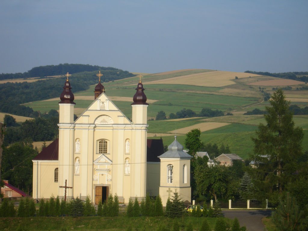
Nowotaniec Village  Main street in Nowotaniec, the centre of village. The latin church parish and Bukowica hill.
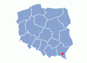
Name origin: new dance [1],[2] Country Poland Region Sanok County District Gmina Bukowsko River Pielnica Elevation 270 m (886 ft) Coordinates 49°30′42″N 22°02′11″E / 49.51167°N 22.03639°E Area 6.8 km2 (3 sq mi) Population 430 (31 December 2002) Density 63 / km2 (163 / sq mi) First mentioned 1366 Mayor (sołtys) Henryk Majka Timezone CET (UTC+1) - summer (DST) CEST (UTC+2) Postal code 38 504 Car plate KUS, RSA 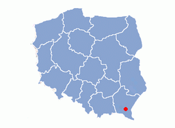 Location of Nowotaniec i Poland
Wikimedia Commons: Nowotaniec Website: http://www.bukowsko.pl 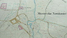
Nowotaniec, (Yiddish: ד בנוביטַניץ' Novitanitz) , (German: Lobetanz, 1409) is a village in south-eastern Poland, inhabited by about 430 (2002), in the Pogórze Bukowskie (Bukowsko Upland) mountains. Situated in the Subcarpathian Voivodeship (since 1999), previously in the Krosno Voivodeship (1975–1998) and the Sanok district, Bukowsko subdistrict, located near the towns of Medzilaborce and Palota (in northeastern Slovakia).
Nowotaniec is bordered on the east by Bukowsko, on the north by Wola Sękowa, on the west by Nadolany, on the right bank of the Pielnica river (a tributary of the Wisłok), on the left side of the highway nr 889 from the railroad running from Sanok to Krosno, and on the west by forests covering the slopes of the Bukowica Range.
This village consists of one street which runs north to south displaying Latin church stone and several houses.[clarification needed]
The parish belongs to the Diocese of Przemyśl, deanery of Sanok. It includes, Nagórzany, Nadolany, and Wola Sękowa. The Roman Catholic cemetery is located 100 m (328 ft) westward of the village center.
Contents
History
Nowotaniec is just up the road from Bukowsko. Historically it has been a mostly Polish village. The region subsequently became part of the Great Moravian state. Upon the invasion of the Hungarian tribes into the heart of the Great Moravian Empire around 899, the Lendians of the area declared their allegiance to Hungarian Empire. The region then became a site of contention between Poland, Kievan Rus' and Hungary starting in at least the 9th century. This area was mentioned for the first time in 981 (by Nestor the Chronicler), when Vladimir the Great of Kiev took the area over on the way into Poland. In 1018 it returned to Poland, 1031 back to Rus', in 1340 Casimir III of Poland recovered it. In the 14th century the Galicia region along with the Sanok district were annexed to Poland by Casimir III the Great of Poland, who began colonisation of these areas (see: Walddeutsche). In the 14th and 15th centuries a number of new settlements were set up, including Trepcza, Czerteż, Prusiek, Nowotaniec, Kostarowce, Tyrawa Solna, Stróże Wielkie and Małe, Hłomcza, Płowce, Sanoczek, Międzybródź. Those settlements were owned by noble and knights’ families. Substantial land was the property of the Kmita family rulidng from Sobień Castle, and Bal from Nowotaniec Castle.
Nowotaniec, with upper-suburb Nagorzany[4], a small town in the county of Sanok, lies in a wooded, hilly area on the highway from Zarszyn to Bukowsko (5.6 km/3.5 mi away). The start of settlement that became Nowotaniec began as a royal village established in 1366 based on the Privilege of Casimir III the Great. The village was founded on the principles of the Magdeburg Rights, and its inhabitants were exempted from all taxes towards the king for a period of twenty years. In 1409, the ownership of Nowotaniec (Lobetanz) was passed over to the knights of Hungary (Petrus Hungarus de Lobetanz) and his brother. The town itself consists of a marketplace and several streets in the valley of the Pielnica river, a tributary of the Wisłok river (ger. Weisslog )on the right bank, elevation 363 m (1,191 ft) above sea level. The parish belongs to the diocese of Przemyśl, deanery of Sanok, and includes Darow, Nadolany, Nagorzany, Pielnia, Puławy, Wola Jaworowa and Wola Sekowa with a total of 1,960 Roman Catholics and 156 Greek Catholics (in 1887). Not far from Nowotaniec lies the castle of Zboiska, built in 1529 by Odnowski, palatinate of Kraków.
The village was a center of the Polish Reformed Church and the Stano family were staunch members of it, supporting a Calvinist church in the village from the end of 16th century till 1713 when they sold the property to Roman Catholics and the Calvinist church in the village was suppressed.
In the first half of the 19th century plagues fell upon the residents of the region. From the time of the Austrian annexation (1772) Nowotaniec became a subdistrict settlement First owner Mathias Bal de Lobetanz (Bals ownership since 1366 - 1556), next owners family de Stano, since 1714 the Bukowskis family. In the 17th century the village was quite important centre of trade and craftsmanship. A good period ended in 1709, when it was looted by the Swedish troops in the Great Northern War. Nowotaniec was owned by the earl Jaworski-Sas since 1767, and currently Krziwkowicz-Pozniak owns to 1944. This part of Poland was controlled by Austria for almost 120 years. At that time the area (including west and east of Subcarpathian Voivodeship) was known as Galicia since 1772. The Roman Catholic Church in Nowotaniec has a collection of records for Nowotaniec and surrounding Roman Catholic villages in its parish like Nadolany and Nagórzany.
The Roman Catholic Church in Nowotaniec was established in 1409, the parish in 1424.
At the end of World War II, after the Germans withdrew, the Ukrainian Insurgent Army became active. Its units terrorised Polish population and destroyed military and police posts. Fights ended in 1947 when as the result of Operation Vistula the Ukrainian population was resettled to Western Poland. Between 1945 - 1949 Nowotaniec was the gmina[clarification needed] due to the destruction of Bukowsko by the Ukrainian Insurgent Army. The village was burned down April 1946 by the Ukrainian Insurgent Army too.[5]
First Jewish families have appeared in Nowotaniec on start 18th century. In year 1765, it lived in village of 74 Jews. They belonged to Rymanów community (kohal) also. However, they have gotten independence earlier, before 1777. Then, 10-12 Jewish families were in village. Four houses belonged to they. In year 1824, community (kohal) counted 84 persons. In year 1870, 249 persons were Jewish inhabitants already. Community owned synagogue and school. 22 pupils walked for school. In year 1900, Jewish community counted 287 persons. Did not have community in village Rabbi. Then, 148 Jews lived in city. In year 1921, village counted 524 half-breeds, these 42 Jews in Nowotaniec. 1885 - Yeshi Michal Gilernter, born 1842 was appointed rabbi [6].
The isolated rural flat land has no sign or marker. No wall, fence, or gate surrounds. Reached by crossing private property, access is open to all. The unknown present owner uses site for agriculture. Properties adjacent are agricultural. Private visitors rarely visit. No maintenance. Vegetation is a seasonal problem preventing access. Water erosion is a moderate threat. For instance, in Podkarpacie, building permits have been granted to wind parks with total capacity of 42,93 MW, among them 3 wind farms: Bukowsko - Nowotaniec – 18 MW and other.
Owners
Bals family (1366–1565) Lilium, de Stanos (1565–1713) Lilium, Bukowskis (1713–1746), Bronieckis (1746–1767), de Sas-Jaworskis (1767–1813) Sas, Wictors de Wiatrowice (1813–1944) Brochwicz, propretarius, de Krziwkowicz-Poźniak (1813–1944) Przestrzał.
Population
Years 1589 1797 1873 2002 Population 175 419 473 430 School
- Zespół Szkół w Nowotańcu, en. Nowotaniec School Complex – Primary and Junior High School
- Head teacher: Anna Bak
- Deputy head teacher: Renata Preisner-Rakoczy
Monuments
- Roman Catholic church new building about 1745, the baroque church in Nowotaniec with historical equipment.
Hiking trails
- European walking route E8
- Wind Farm Bukowsko-Nowotaniec
Industry
- Wind Farm Bukowsko-Nowotaniec
see also
Main article: LendiansMain article: Great MoraviaMain article: OstsiedlungMain article: Kingdom of Galicia and LodomeriaMain article: Ruthenian VoivodeshipMain article: Lwów VoivodeshipMain article: WalddeutscheMain article: PogórzanieTwin cities
- Topoľovka
- Maizières-lès-Metz
- Time zone; UTC+1/SummerUTC+2
Literature
- Dr. Maurycy Maciszewski. Geographical Dictionary. "A Geographical Dictionary of Polish Kingdom". Vols. 1-15 reprinted from 1880-1902 Warsaw. ; Nowotaniec - translated by William Fred Hoffman, PGSA Fall 2001 Rodziny (digital edition)
- Prof. Przemysław Dąbkowski. Stosunki narodowościowe w ziemi sanockiej w XV wieku. Lwów. 1921.
- Dr. Adam Fastnacht. Slownik Historyczno-Geograficzny Ziemi Sanockiej w Średniowieczu (Historic-Geographic Dictionary of the Sanok District in the Middle Ages), Kraków, 2002, ISBN 83-88385-14-3.
- Records of the Institut für Deutsche Ostarbeit, Sektion für Rasse- und –Volkstumforschung 1940-1943. Boxes 50-51, 50. [Forms with pictures of people from Nowotaniec]
- Dr. Kurt Lück. Deutsche Aufbaukräfte in der Entwicklung Polens. Forschungen zur deutsch-polnischen Nachbarschaft im ostmitteleuropäischen Raum 1934, ; Nowotaniec; pages 584-606
- Prof. Feliks Kiryk - Rocznik sanocki. 2006. "Bukowsko-Nowotaniec" str. 92-115
- Jerzy Zuba "W Gminie Bukowsko". Roksana, 2004, ISBN 83-7343-150-0. Translated by Deborah Greenlee. Arlington, TX 76016.
References
- ^ Nowotaniec was founded in the 14th century as German colony; it is first mentioned in 1366. Etymology from German personal name Lobetanz (Peter de Lobetanz), from/or name of inn " ger. lobe, laud + tanz, dance ".
- ^ Prof. Barbara Czopek-Kopciuch. Adaptacje niemieckich nazw miejscowych w języku polskim. PAN, IJP. Kraków. 1995. ISBN 83-85579-33-8, page. 76
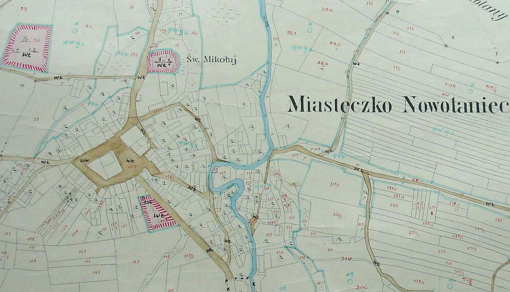
- ^ Markt Nowotaniec mit der Ortschaft Nagorzany in Galizien, Kreis Sanok, Steuerbezirk Bukowsko [Miasteczko Nowotaniec z miejscowością Nagórzany, pow. Sanok, pow. podatkowy Bukowsko - Galicja]; ewidencja gruntów; 1854; 1854. sygnatura: 59/1313/0/0 nr. poz. 2571. Kataster gruntowy, Archiwum Państwowe w Rzeszowie.
- ^ " Nowotaniec, with Zagorzany, a small town in the county of Sanok, lies in a wooded, hilly area on the highway from Zarszyn to Bukowsko (5.6 km. away). The town itself consists of a marketplace and several streets in the valley of the Pielnica River, a tributary of the Wislok on the right bank, elevation 363 meters above sea level. Several streams flow into the Pielnica there from nearby hills, namely, on the west from Wysoka gora (432 meters), and on the east from Bukowica (541 meters). To the north the village of Nadolany and to the south the village of Nagorzany create a kind of sub-urb. Nowotaniec itself has 595 inhabitants, 428 Roman Catholic, 11 Greek Catholic,and 156 Jews. A Roman Catholic parish is headquartered there, with a beautiful church made of stone; there are also an elementary school, a manor transformed from an ancient castle, and a brewery. There is a weekly market held every Mon-day, as well as four annual fairs: on the Monday after the feast of the Holy Trinity, and on the 1st of May, 2nd of August, and 11th of November. The major estate has 16 morgs of farmland; the minor estate [land owned by peasants] has 496 morgs of farm-land, 40 of meadows, and 35 of forests. We do not know much about the history of Nowotaniec. The date of its founding is unknown. In the 15th century there was a German settlement there called Lebetanz, and Piotr, its noble owner, signed his name to the document founding the parish in Humniska. Later the name was changed to Nebetanz, and finally to the one it bears today. In the 16th century the latter name had already come into general use, spelled Nowothancze or Nowotancze. The Archiwum grodzkie i ziemskie (vol. IX, Lwow 1885) contains two documents signed by Stanislaw Bal and Maciej Bal, castellans of Sanok. Nowotaniec remained in the Bals' possession until the time of King Stefan Batory. Jan Bal, cupbearer of Sanok, founded a parish there in 1492. Later Nowotaniec came to be owned - partly by way of inheritance, partly through purchases - by the Hungarian family de Stano related to the Bals. The 16th century was marked by intensified conflicts caused by the worsened living conditions in villages. Arian and Calvinistic (Nowotaniec) congregations were established, promoting protestant ideas. Hieronim de Stano was a religious dissenter and converted the church into a Helvetian congregation [i. e., Calvinist or other Swiss Protestant sect], and he paid for a minister for the congregation; but in 1613 it was returned to the Catholics. In 1643 the Sejm wanted to elevate this settlement, and for this reason established a warehouse there for Hungarian wine. During Bishop Denhoff's inspection visit in 1699 it was recorded that on one side of the church stood the castle of Aleksander de Stano, and on the other a congregation of dissenters. Several years later Boguslaw Stan sold Nowotaniec to Bukowski, royal chamberlain, and he built the church that still exists today, which was consecrated by Bishop Sierakowski in 1745 under the name of St. Mikolaj [St. Nicholas]. The parish belongs to the diocese of Przemysl, deanery of Sanok, and includes Darow, Nadolany, Nagorzany, Pielnia, Pulawy, Wola Jaworowska, and Wola Selkowa [this is probably Sekowa Wola], with a total of 1,960 Roman Catholics and 156 Greek Catholics. Not far from Nowotaniec lies the castle of Zborsko, built in 1529 by Odnowski, palatinate of Krakow. After the Bukowskis, Nowotaniec was owned by the Bronieckis, and currently Wiktor Pozniak owns the major estate and the exclusive right to produce and sell alcohol on its grounds". [Mac. (Dr. Maurycy Maciszewski) Vol. VII, pp. 290-291]. Warszawa. [in] : [1]. Translated by William Fred Hoffman, PGSA Fall 2001 Rodziny
- ^ 3,000 in rebel band terrorized Galicia, Ukrainian Nationalists, German deserters led by SS colonel burn 3 villages (Nowoataniec, Nagórzany, Bukowsko) in a night (by wireless to The New York Times) Sanok, Poland, April 17, 1946 – a strong, well-organized and elusive band of Ukrainian nationalists and German deserters, estimated at more than 3,000 under the leadership of a German colonel, in a fortnight have succeeded in transformating this sector of the Carpathian foothills of old Galicia into a virtual partisan stronghold. With the burning of three large villages on a single night two weeks ago, they now have made 10,000 of thise area's total pre war population of 135,000 homeless and are resisting with complete success all efforts to quell what is tantamount to open insurrection. [...] The writer of this dispatch lat week went to the heart of the bandit country, to the village of Bukowsko, where on the night of April 4 the bandits burned down all but eleven of the 400 houses and made more than 3,000 persons homeless. Our escort consisted of therefugee Mayor, now in Sanok and two squads of well-armed Security Police under the command of a nervous 20-year-old second lieutenant. Before burning the village the bandits who were well armed with German and Russian automatics and machine guns, had demanded 1,000,000 zlotys tribute, and the village had raised 300,000. On the night of the fire the villagers received scant warning a few hours before from a peasant that the bandits were coming, but had not had time to remove their cattle.
- ^ Shtetl Finder: Jewish Communities in the 19th and Early 20th Centuries in the Pale of Settlement of Russia and Poland, and in Lithuania, Latvia, Galicia, and Bukovina, with Names of Residents. Author: Chester G. Cohen Heritage Books, 1989. ISBN 1556132484
External links
- Map of Nowotaniec
- The trip to Nowotaniec - short movies . A trip to village Nowotaniec, start in the Nagorzany to finish off the Nadolany. The trip starts in Nagorzany, quickly drives through the main street of Nowotaniec and ends in Nadolany.
- Geographical Dictionary of the Kingdom of Poland and other Slavic Lands Słownik geograficzny Królestwa Polskiego i innych krajów słowiańskich. . Warszawa. 1876. (digital edition)
Seat 
Other villages Categories:- Villages in Sanok County
- Zespół Szkół w Nowotańcu, en. Nowotaniec School Complex – Primary and Junior High School


Wikimedia Foundation. 2010.