- Tokarnia, Sanok County
Infobox City
settlement_type = village
subdivision_type = Country
official_name = Tokarnia| native_name = Tokarnia| subdivision_name = Poland
image_
subdivision_type1 =Bieszczady Mountains
subdivision_name1 =Subcarpathian Voivodship
population_total = 200
area_total_km2 = 4.8
elevation_m = 270
established_date = 1526
established_title =Founded
code = 38-500
latd =
latm =
latNS =
longd =
longm =
longEW =
website =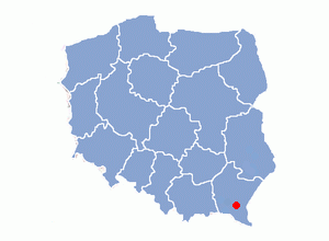
Tokarnia, village in East Małopolska in the Lesser Beskid mountains,
Bukowsko rural commune. Tokarnia about 10 miles fromSanok in south-eastern Poland. It is situated below the main watershed at the foot of the Słonne Mountain, and has an elevation of 270 metres. Situated in theSubcarpathian Voivodship (since 1999), previously inKrosno Voivodship (1975-1998) andSanok district, (10 miles east of Sanok).Tokarnia was founded in 1526 by Herburt. From 966-1018,
1340 -1772 (Ruthenian Voivodeship ) and from 1918-1939 Tokarnia was part of Poland. While during 1772-1918 it belonged to Austrian empire, later Austrian-Hungarian empire when double monarchy was introduced in Austria. This part of Poland was controlled byAustria for almost 120years. At that time the area (including west and east ofSubcarpathian Voivodship ) was known as Galicia.The Roman Catholic parish for Tokarnia is located in
Bukowsko . It's diocesan was located inPrzemyśl . The Roman Catholic Archdiocesan Archives inPrzemyśl has some records for Tokarnia which are of a different time period. The wooden church was built and blessed in 1785. The church was destroyed in 1946 by UPA.The rural families are poor, agriculture is rarely profitable and low income makes it difficult for farms to invest in from improvements.
Most popular surnames in the region
*Surnames (19th) : Bierówka, Celep, Dewerenda, Dyrcz, Falter, Hołak, Luberda, Leszanty, Misko, Mirek, Makara, Makawa, Janicki, Kuncio, Korabik, Kril, Konik, Kuryl, Kuryło, Padubiński, Ostafi, Pańko, Piszczatyn, Podwapiński, Roman, Romaniak, Sadowski, Szpynda, Śliz, Szczerba, Szponda, Szuszko (or Suszko), Tais, Tauftar, Tylawski, Wutzke.
Time zone :
UTC+1 /SummerUTC+2
Wikimedia Foundation. 2010.