- Bukowsko
Geobox|Settlement
name = Bukowsko
category = Village
etymology = Its name comes from the west slavic dialect word "buk", meaning "beech " ("beech eswood ")
official_name = Bukowsko
motto =
nickname =
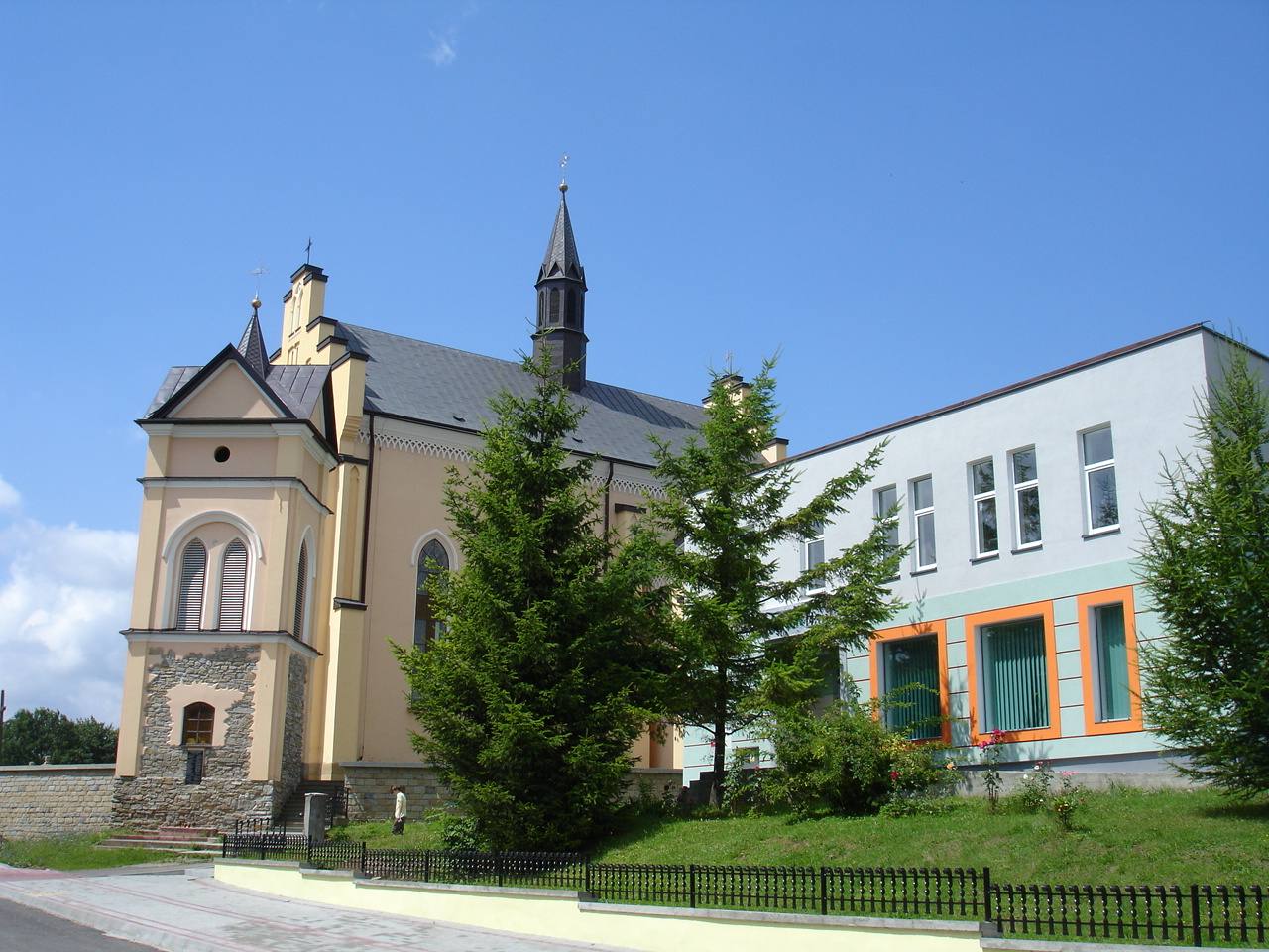
image_caption = Main street in Bukowsko, the centre of village. The latin church parish and city bank.
symbol = POL Bukowsko COA.svg
symbol_type =
country = Poland
country_
state =
region = Sanok County
district = Gmina Bukowsko
municipality =
landmark =
river = Sanoczek
location =
elevation = 340
prominence =
lat_d =49 | lat_m =31 | lat_s =10 | lat_NS =N
long_d =22 | long_m =02 | long_s =30 | long_EW =E
highest =
highest_location = | highest_region = | highest_state =
highest_elevation =
highest_lat_d = | highest_lat_m = | highest_lat_s = | highest_lat_NS =
highest_long_d = | highest_long_m = | highest_long_s = | highest_long_EW =
lowest =
lowest_location = | lowest_region = | lowest_state =
lowest_elevation =
lowest_lat_d = | lowest_lat_m = | lowest_lat_s = | lowest_lat_NS =
lowest_long_d = | lowest_long_m = | lowest_long_s = | lowest_long_EW =
length = | length_orientation =
width = | width_orientation =
area = 8.2
area_land =
area_water =
area_urban =
area_metro =
population =1500 | population_date =31 December 2002
population_urban =
population_metro =
population_density = auto
population_density_urban =
population_density_metro =
established =1361
established_type = First mentioned
date =
government =
government_location = | government_region = | government_state =
government_elevation =
government_lat_d = | government_lat_m = | government_lat_s = | government_lat_NS =
government_long_d = | government_long_m = | government_long_s = | government_long_EW =
mayor =
leader =sołtys Kazimierz Zadylak
timezone =CET | utc_offset =+1
timezone_DST =CEST | utc_offset_DST =+2
postal_code = 38 504
area_code =
area_code_type = Phone prefix
code = KUS, RSA
code_type = free_type =
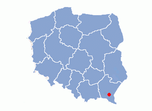
map_caption = Location of Bukowsko in Poland
map_background =
map_locator =
map1 =
map1_caption =
map1_background =
map1_locator =
commons = Bukowsko
statistics =
website = http://www.bukowsko.pl
footnotes =. The rest destroyed tombstones had been use as material to the road of the Bukowsko street in 1942-1943, but about 10 tombstones remain.]
[ the center of village. Building on the left is the Dom Ludowy ("Agricultural Circle") which is used for weddingreceptions, etc. Beyond is the green kiosk ("traffica") where you can purchase things such as magazines, maps, postcards, comic books, small toys, cigarettes, drinks and so on. On the right side of the street at the far end is the Roman Catholic church, then the
 bank and then the commune council building with "USC" Civil registry.] ] Bukowsko ( _yi. בוקאווסק "Bikofsk", Russian: "Буковско") is avillage inSanok County , East Małopolska in the Bukowsko Upland mountains, parish "in loco", located near the towns ofMedzilaborce andPalota (in northeasternSlovakia ).Characteristics
It is an administrative and cultural centre of the
Gmina Bukowsko . It is crossed by the rail road connecting it with Slovakia. It is especially the private sector and service industries that are developing rapidly at this time.It is home to the Uniwersytet Ludowy, opened in 2005, which contains many artworks and effects of thee folk handworks inspiration. Bukowsko is situated in the poorest region of Poland.History
Settled in prehistoric times, the southern-eastern Poland region that is now Podkarpacie was overrun in pre-Roman times by various tribes, including the
Celts ,Goths andVandals (Przeworsk culture ). After the fall of the Roman Empire, of which most of sountern-eastern Poland was part (all parts below the San), the area was invaded by Hungarians and Slavs. The region subsequently became part of theGreat Moravia n state. Upon the invasion of the Hungarian tribes into the heart of the Great Moravian Empire around 899, theLendians of the area declared their allegiance to Hungarian Empire. The region then became a site of contention betweenPoland , Kievan Rus andHungary starting in at least the 9th century. This area was mentioned for the first time in 981 (by Nestor) , whenVolodymyr the Great ofKievan Rus took the area over on the way intoPoland . In 1018 it returned to Poland, 1031 back to Rus, in 1340Casimir III of Poland recovered it.In historical records the village was first mentioned in 1361. During 966 - 1018, 1340 - 1772 (
Ruthenian Voivodeship ) and during 1918 - 1939 Bukowsko was part of Poland. While during 1772 - 1918 it belonged to Austrian empire, later Austrian-Hungarian empire when double monarchy was introduced in Austria. This part of Poland was controlled byAustria for almost 120 years. At that time the area (including west and east ofSubcarpathian Voivodship ) was known as Galicia. It was given theMagdeburg law in 1768. In 1785 the village lands comprised 6.5 km². There were 700 Catholics. In 1864 Rabbi Shlomo Halberstam was appointed as rabbi of the Jewish community of Bukowsko. He held this position until 1879. The village was burned down January, March and November 1946 [ 3,000 in rebel band terrorized Galicia, Ukrainian Nationalists, German deserters led by SS colonel burn 3 villages in a night (by wireless toThe New York Times ) Sanok, Poland,April 17 ,1946 – a strong, well-organized and elusive band of Ukrainian nationalists and German deserters, estimated at more than 3,000 under the leadership of a German colonel, in a fortnight have succeeded in transformating this sector of the Carpathian foothills of old Galicia into a virtual partisan stronghold. With the burning of three large villages on a single night two weeks ago, they now have made 10,000 of thise area's total pre war population of 135,000 homeless and are resisting with complete success all efforts to quell what is tantamount to open insurrection. By burning an avarange of two bridges a day for the last three months, they have completely disrupted communications in this thckly populated but primitive backwoods country and have made it virtually impossible for security police and two Polish divisions to rout them out. By stealing cattle and demanding tributes of a million zlotys (about $10,000) they appear capable of holding out indefinitely in their wooded hide-outs. Gradually the small bands joined forces with a leader said by Polish officials to be a German SS [Elite Guard] colonel, which is plausible, since the Ukrainian SS was organized by the renegade General Pethuse, whom the Germans reportedly liquidated in 1943 after he had served his purpose as the rallying point for the traditionally anti-Communist Ukrainians. The present insurrectionist leader is know by all - by peasant and officials alike – as "The Colonel". The band itself is known as the Banderowce. After one Colonel Banderowce. A Ukrainian who apparently became a legend in this part of the world for his fight with the Ukrainians against the Communists after the last war. The writer of this dispatch lat week went to the heart of the bandit country, to the village of Bukowsko, where on the night of April 4 the bandits burned down all but eleven of the 400 houses and made more than 3,000 persons homeless. Our escort consisted of therefugee Mayor, now in Sanok and two squads of well-armed Security Police under the command of a nervous 20-year-old second lieutenant. Before burning the village the bandits who were well armed with German and Russian automatics and machine guns, had demanded 1,000,000 zlotys tribute, and the village had raised 300,000. On the night of the fire the villagers received scant warning a few hours before from a peasant that the bandits were coming, but had not had time to remove their cattle. ] by theUPA . Only over a dozen years after the war the village started to rebuild.According to "The Holocaust: The Jews in the County of Cracau" on Bukowsko near
Płonna was the site of a "special camp" in 1942. The camp was used to hold Jews from theSanok ,Lesko and Dobromil powiats, that is if they weren't shot in their village or taken to the work camp in Zwangsarbeitslager Zaslaw, 30 km east of Bukowsko. Bukowsko also had a labor camp which existed from August to Oct. of 1942. The Jews, 60 on average, carried out road construction. These Jews were then sent to Zaslaw. Apparently at least 13,000 people were held at Zasław and then transported toBelzec . The old people were shot in the woods near Zasław.Population
* 1899 - 1893 Poles, 833 Jews
* 1932 - 2325Poles , 650Jews , 5Ukrainians .
* 2005 - 1500 PolesGeography
The
municipality lies at analtitude of 482metres and covers anarea of 8.3 km². It has apopulation of about 1500 people. The village of Bukowsko lies in a valley of the Sanoczek river in northeastern Poland. The hills of theBieszczady mountain range are typical for this countryside.Time zone:UTC+1 /SummerUTC+2 Village parts: Dział; Sanoczek; Łaźniakowa Góra; Podwapienne; Pasieki.Twin cities
*
Topoľovka
*Maizières-lès-Metz Personalia
* Shlomo Halberstam
* Ben Zion Halberstam
*Feliks Kiryk
*Adam Didur
* Anastazy Jakub Pankiewicz
*Julian Krzyżanowski
*Alojzy Ehrlich , (Hasmonea Lwów )Hiking trails
*
European walking route E8 See also
*
Dialekt małopolski
**Gwara sądecka Literature
* Prof.
Adam Fastnacht . Slownik Historyczno-Geograficzny Ziemi Sanockiej w Średniowieczu (Historic-Geographic Dictionary of the Sanok District in the Middle Ages), Kraków, 2002, ISBN 83-88385-14-3.Rural landscape pictures
References
::Inline:
External links
* [http://www.zumi.pl/drukuj.html?typ=/namapie.html&qt=&loc=Bukowsko&Submit=Szukaj&cId=&sId=&x=58&y=13&x=22.0629914&y=49.4804756&scale=2&mapKind=3 Map of Bukowsko]
* [http://video.google.com/videoplay?docid=9141896418224555612&q=schwerd Bernard Schwerd trip to Bukowsko (Zboiska-Wolica-Bukowsko-Wola Piotrowa-Bukowsko)]
* [http://www.wyciag-karlikow.pl/ Karlikow Ski-park]
* [http://www.wolapiotrowa.chsi.pl/ protenstant parish in Wola Piotrowa]
* [http://republika.pl/zboiska/ Caritas in Zboiska]
* [http://zamki.res.pl/ Castle in Zboiska]
* [http://www.shtetlinks.jewishgen.org/bukowsko/ Bukowsko shtetl]
* [http://www.jewishgen.org/Yizkor/sanok/San579.html Bukowsto shtetl - story]

Wikimedia Foundation. 2010.