- Over Kellet
-
Coordinates: 54°07′26″N 2°44′02″W / 54.124°N 2.734°W
Over Kellet 
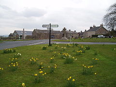
Village Green
 Over Kellet shown within Lancashire
Population 778 (2001) OS grid reference SD520700 Parish Over Kellet District Lancaster Shire county Lancashire Region North West Country England Sovereign state United Kingdom Post town CARNFORTH Postcode district LA6 Dialling code 01524 Police Lancashire Fire Lancashire Ambulance North West EU Parliament North West England UK Parliament Morecambe and Lunesdale List of places: UK • England • Lancashire Over Kellet is a village and civil parish near Carnforth in the English county of Lancashire. The parish, which is in the City of Lancaster, includes the village of Capernwray, at its northern end, and has a population of 778.[1] The Lancaster Canal passes through the parish.[2]
The village was referred to as Chellet in the Domesday Book, and more recently has also been known as Lesser Kellet.[2] It is approximately 1 mile (1.6 km) east of Carnforth, and 0.6 miles (0.97 km) east of junction 35 of the M6 motorway.
The Church of St Cuthbert, has existed since 1215.[3] The current building a Grade II* listed building,[4] mostly built in the 16th century. It was restored in 1864, and is now a joint Anglican/Methodist church.[3]
References
- ^ Office for National Statistics : Census 2001 : Parish Headcounts : Lancaster Retrieved 12 February 2010
- ^ a b William Farrer & J. Brownbill (editors) (1914). "Townships: Over Kellet". A History of the County of Lancaster: Volume 8. pp. 140–151. http://www.british-history.ac.uk/report.aspx?compid=53285. Retrieved 2008-04-28.
- ^ a b "Blackburn Diocesan Web Site". Diocese of Blackburn. 2008-04-22. http://www.blackburn.anglican.org/index.php?http://www.blackburn.anglican.org/diodir/tundean.htm. Retrieved 2008-04-28.[dead link]
- ^ "Lancashire Parish Portal: Parish Council Details: Over Kellet Parish Council". Lancashire County Council. http://www.lancashireparishcouncils.gov.uk/parishes/parish_display.asp?parishid=73. Retrieved 2008-04-28.
External links
Ceremonial county of Lancashire North West England Portal Unitary authorities Boroughs or districts Major settlements Accrington • Adlington • Bacup • Barnoldswick • Blackburn • Blackpool • Brierfield • Burnley • Burscough • Carnforth • Chorley • Clayton-le-Moors • Cleveleys • Clitheroe • Colne • Darwen • Earby • Fleetwood • Garstang • Great Harwood • Haslingden • Kirkham • Lancaster • Leyland • Longridge • Lytham St Annes • Morecambe • Nelson • Ormskirk • Oswaldtwistle • Padiham • Penwortham • Poulton-le-Fylde • Preesall • Preston • Rawtenstall • Rishton • Skelmersdale • Wesham • Whitworth
See also: List of civil parishes in LancashireRivers Canals Topics Categories:- Geography of Lancaster
- Civil parishes in Lancashire
- Villages in Lancashire
- Lancashire geography stubs
Wikimedia Foundation. 2010.

