- Columbia, South Carolina metropolitan area
-
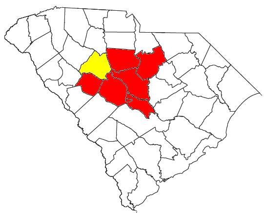
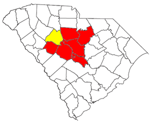 Location of the Columbia-Newberry CSA and its components:
 Columbia Metropolitan Statistical AreaNewberry Micropolitan Statistical Area
As defined by the U.S. Office of Management and Budget, and used by the U.S. Census Bureau for statistical purposes only[1], the Columbia Metropolitan Statistical Area, is an area consisting of six counties in central South Carolina, anchored by the city of Columbia. As of the 2000 census, the MSA had a population of 647,158 (though a July 1, 2009 estimate placed the population at 744,730).[2] It is the largest metropolitan statistical area in the state of South Carolina.
Contents
Counties
Communities
Places with more than 100,000 inhabitants
- Columbia (Principal city)
Places with 10,000 to 25,000 inhabitants
- Cayce
- Dentsville (census-designated place)
- Forest Acres
- Irmo
- Lexington
- Seven Oaks (census-designated place)
- St. Andrews (census-designated place)
- West Columbia
Places with 5,000 to 10,000 inhabitants
- Batesburg-Leesville
- Camden
- Lugoff (census-designated place)
- Oak Grove (census-designated place)
- Red Bank (census-designated place)
- Woodfield (census-designated place)
Places with 1,000 to 5,000 inhabitants
- Gaston
- Lake Murray of Richland (census-designated place)
- Pine Ridge
- St. Matthews
- Saluda
- South Congaree
- Springdale
- Winnsboro Mills (census-designated place)
- Winnsboro
Places with less than 1,000 inhabitants
- Arcadia Lakes
- Bethune
- Blythewood
- Cameron
- Chapin
- Eastover
- Elgin
- Gilbert
- Monetta (partial)
- Pelion
- Ridge Spring
- Ridgeway
- Summit
- Swansea
- Ward
Unincorporated places
- Antioch
- Arthurtown
- Ballentine
- Boyden Arbor
- Boykin
- Cassatt
- Creston
- Feasterville
- Fort Motte
- Gadsden
- Harbison
- Hilton
- Hopkins
- Horrell Hill
- Killian
- Kingville
- Leesburg
- Liberty Hill
- Lone Star
- Lykes
- Mitford
- Olympia
- Pontiac
- Sandy Run
- Spring Hill
- State Park
- Wateree
- Westville
- White Rock
- Windsor Estates
Demographics
As of the census[3] of 2000, there were 647,158 people, 245,347 households, and 167,105 families residing within the MSA. The racial makeup of the MSA was 63.40% White, 32.90% African American, 0.27% Native American, 1.24% Asian, 0.06% Pacific Islander, 1.01% from other races, and 1.12% from two or more races. Hispanic or Latino of any race were 2.41% of the population.
The median income for a household in the MSA was $37,051, and the median income for a family was $44,051. Males had a median income of $32,119 versus $23,312 for females. The per capita income for the MSA was $18,150.
Combined Statistical Area
The Columbia–Newberry Combined Statistical Area is made up of seven counties in central South Carolina. The statistical area includes one metropolitan area and one micropolitan area. As of the 2000 Census, the CSA had a population of 683,266 (though a July 1, 2009 estimate placed the population at 783,493), and is the second largest CSA in South Carolina.[4]
- Metropolitan Statistical Areas (MSAs)
- Columbia (Calhoun, Fairfield, Kershaw, Lexington, Saluda, and Richland counties)
- Micropolitan Statistical Areas (μSAs)
- Newberry (Newberry County)
See also
References
- ^ See section 5 for definition and proper use of Metropolitan Statistical Area
- ^ "Table 1. Annual Estimates of the Population of Metropolitan and Micropolitan Statistical Areas: April 1, 2000 to July 1, 2009 (CBSA-EST2009-01)" (CSV). 2009 Population Estimates. United States Census Bureau, Population Division. 2010-03-23. http://www.census.gov/popest/metro/tables/2009/CBSA-EST2009-01.csv. Retrieved 2010-03-24.
- ^ "American FactFinder". United States Census Bureau. http://factfinder.census.gov. Retrieved 2008-01-31.
- ^ "Table 2. Annual Estimates of the Population of Combined Statistical Areas: April 1, 2000 to July 1, 2009 (CBSA-EST2009-02)" (CSV). 2009 Population Estimates. United States Census Bureau, Population Division. 2010-03-23. http://www.census.gov/popest/metro/tables/2009/CBSA-EST2009-02.csv. Retrieved 2010-03-24.
Wikimedia Foundation. 2010.