- Mannington Township, New Jersey
-
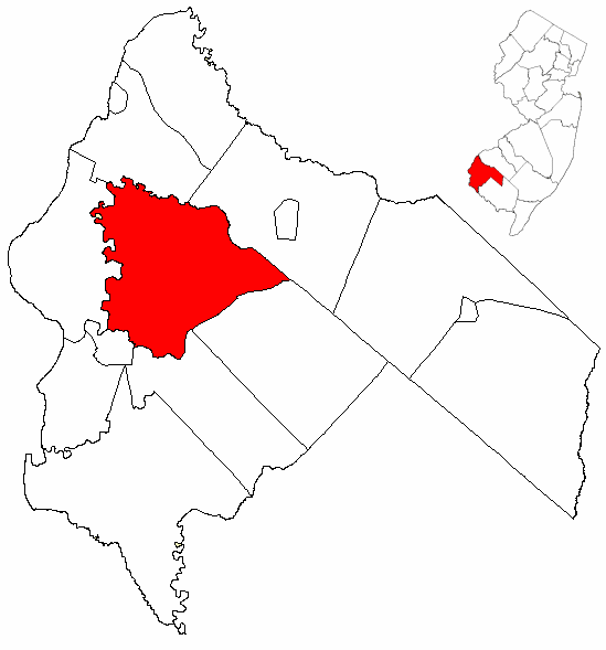
Mannington Township, New Jersey — Township — Mannington Township highlighted in Salem County. Inset map: Salem County highlighted in the State of New Jersey. Census Bureau map of Mannington Township, New Jersey
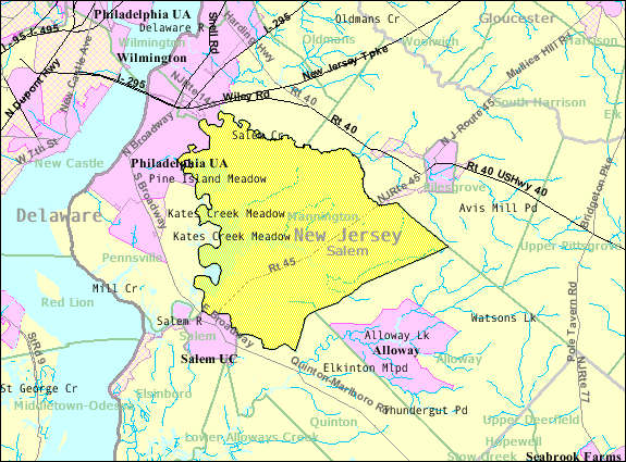
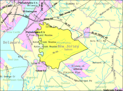
Coordinates: 39°36′45″N 75°24′28″W / 39.6125°N 75.40778°WCoordinates: 39°36′45″N 75°24′28″W / 39.6125°N 75.40778°W Country United States State New Jersey County Salem Mentioned May 12, 1701 Incorporated February 21, 1798 Government[1] – Type Township (New Jersey) – Mayor Donald C. Asay Area – Total 38.4 sq mi (99.5 km2) – Land 34.8 sq mi (90.1 km2) – Water 3.6 sq mi (9.4 km2) Elevation[2] 30 ft (9 m) Population (2007)[3] – Total 1,555 – Density 44.8/sq mi (17.3/km2) Time zone Eastern (EST) (UTC-5) – Summer (DST) EDT (UTC-4) ZIP code 08079 Area code(s) 856 FIPS code 34-43200[4][5] GNIS feature ID 0882133[6] Mannington Township is a Township in Salem County, New Jersey, United States. As of the United States 2000 Census, the township population was 1,559.
Mannington Township was first mentioned on May 12, 1721. It had been previously known as East Fenwick Township, which was mentioned on September 3, 1679, though the details of its incorporation are unknown. The township was incorporated by an Act of the New Jersey Legislature on February 21, 1798 as one of New Jersey's original group of 104 townships. A portion of the township was taken in 1878 and annexed by Quinton Township.[7]
Contents
Geography
According to the United States Census Bureau, the township has a total area of 38.4 square miles (99 km2), of which, 34.8 square miles (90 km2) of it is land and 3.6 square miles (9.3 km2) of it (9.47%) is water. The Salem River flows along the township's northern and western boundaries.[8]
Mannington Township borders Carneys Point Township, Pilesgrove Township, Alloway Township, Quinton Township, Salem, and Pennsville Township.
Demographics
Historical populations Census Pop. %± 1850 2,187 — 1860 2,393 9.4% 1870 2,351 −1.8% 1880 2,230 −5.1% 1890 1,870 −16.1% 1900 1,745 −6.7% 1910 1,606 −8.0% 1920 1,456 −9.3% 1930 1,584 8.8% 1940 1,656 4.5% 1950 1,686 1.8% 1960 2,024 20.0% 1970 1,913 −5.5% 1980 1,740 −9.0% 1990 1,693 −2.7% 2000 1,559 −7.9% Est. 2007 1,555 [3] −0.3% Population 1930 - 1990[9][10][11] As of the census[4] of 2000, there were 1,559 people, 539 households, and 409 families residing in the township. The population density was 44.8 people per square mile (17.3/km²). There were 573 housing units at an average density of 16.5 per square mile (6.4/km²). The racial makeup of the township was 75.63% White, 20.91% African American, 0.51% Native American, 0.38% Asian, 1.73% from other races, and 0.83% from two or more races. Hispanic or Latino of any race were 3.34% of the population.
There were 539 households out of which 26.5% had children under the age of 18 living with them, 60.9% were married couples living together, 10.4% had a female householder with no husband present, and 24.1% were non-families. 20.6% of all households were made up of individuals and 10.0% had someone living alone who was 65 years of age or older. The average household size was 2.63 and the average family size was 3.02.
In the township the population was spread out with 22.6% under the age of 18, 4.8% from 18 to 24, 25.5% from 25 to 44, 23.7% from 45 to 64, and 23.4% who were 65 years of age or older. The median age was 43 years. For every 100 females there were 95.9 males. For every 100 females age 18 and over, there were 88.6 males.
The median income for a household in the township was $52,625, and the median income for a family was $62,500. Males had a median income of $45,714 versus $29,727 for females. The per capita income for the township was $24,262. About 3.8% of families and 6.9% of the population were below the poverty line, including 11.5% of those under age 18 and 8.1% of those age 65 or over.
Government
Local government
Mannington Township is governed under the Township form of government with a three-member Township Committee. The Township Committee is elected directly by the voters in partisan elections to serve three-year terms of office on a staggered basis, with one seat coming up for election each year.[1] At an annual reorganization meeting, the Township Committee selects one of its members to serve as Mayor.
Members of the Mannington Township Committee are Mayor Donald C. Asay, Deputy Mayor Ernest F. Tark, Jr. and George B. Wright.[12]
Federal, state and county representation
Mannington Township is in the 2nd Congressional district. New Jersey's Second Congressional District is represented by Frank LoBiondo (R, Ventnor City). New Jersey is represented in the United States Senate by Frank Lautenberg (D, Cliffside Park) and Bob Menendez (D, Hoboken).
Mannington Township is in the 3rd legislative district of the New Jersey Legislature, which is represented in the New Jersey Senate by Stephen M. Sweeney (D, West Deptford Township) and in the New Jersey General Assembly by John J. Burzichelli (D, Paulsboro) and Celeste Riley (D, Bridgeton).[13]
Salem County is governed by a seven-member Board of Chosen Freeholders who are elected at-large to serve three-year terms of office on a staggered basis, with either two or three seats coming up for election each year. As of 2011, Salem County's Freeholders are Director Lee R. Ware (Elsinboro Township), Deputy Director David Lindenmuth (Woodstown), Julie A. Acton (Pennsville Township), Bruce L. Bobbitt (Pilesgrove Township), Dale A. Cross (Pennsville Township), Ben Laury (Elmer) and Beth E. Timberman (Woodstown).[14]
Education
The Mannington Township School District serves students in pre-kindergarten through eighth grade. The Mannington Township School had an enrollment of 158 students in the 2005-06 school year.[15]
For grades 9-12, students attend Salem High School in Salem City, as part of a sending/receiving relationship with the Salem City School District.[16]
References
- ^ a b 2005 New Jersey Legislative District Data Book, Rutgers University Edward J. Bloustein School of Planning and Public Policy, April 2006, p. 19.
- ^ U.S. Geological Survey Geographic Names Information System: Township of Mannington, Geographic Names Information System, accessed January 4, 2008.
- ^ a b Census data for Mannington Township, United States Census Bureau. Accessed December 25, 2008.
- ^ a b "American FactFinder". United States Census Bureau. http://factfinder.census.gov. Retrieved 2008-01-31.
- ^ A Cure for the Common Codes: New Jersey, Missouri Census Data Center. Accessed July 14, 2008.
- ^ "US Board on Geographic Names". United States Geological Survey. 2007-10-25. http://geonames.usgs.gov. Retrieved 2008-01-31.
- ^ "The Story of New Jersey's Civil Boundaries: 1606-1968", John P. Snyder, Bureau of Geology and Topography; Trenton, New Jersey; 1969. p. 216.
- ^ DeLorme (2005). New Jersey Atlas & Gazetteer. Yarmouth, Maine: DeLorme. ISBN 0-89933-324-9.
- ^ New Jersey Resident Population by Municipality: 1930 - 1990, Workforce New Jersey Public Information Network. Accessed March 1, 2007.
- ^ "U.S. Census Historical Data 1790-2000". http://www.census.gov/prod/www/abs/decennial/index.htm. Retrieved 2007-03-16.
- ^ Data for 1790-1840 not available
- ^ Mannington Township, [{Salem County, new Jersey. Accessed December 25, 2008.
- ^ "Legislative Roster: 2010-2011 Session". New Jersey Legislature. http://www.njleg.state.nj.us/members/roster.asp. Retrieved 2010-02-08.
- ^ 2011 Board of Chosen Freeholders, Salem County, New Jersey. Accessed February 9, 2011.
- ^ Data for the Mannington Township School, National Center for Education Statistics. Accessed December 25, 2008.
- ^ Salem High School 2006 School Report Card, New Jersey Department of Education. Accessed January 27, 2008. "Salem High School is one of the oldest comprehensive high schools in the State of New Jersey. Our high school is proud to serve its students in grades 9-12 from Salem City, Elsinboro, Lower Alloways Creek, Mannington, and Quinton."
External links
- Salem County Web Page for Mannington Township
- Mannington Township School
- Mannington Township School's 2009–10 School Report Card from the New Jersey Department of Education
- Data for the Mannington Township School, National Center for Education Statistics
Municipalities and communities of Salem County, New Jersey City 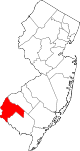
Boroughs Townships Alloway | Carneys Point | Elsinboro | Lower Alloways Creek | Mannington | Oldmans | Pennsville | Pilesgrove | Pittsgrove | Quinton | Upper Pittsgrove
CDPs Alloway | Carneys Point | Pennsville | Olivet
Communities Auburn | Brotmanville | Centerton | Deepwater | Hancock's Bridge | Monroeville | Pedricktown
Categories:- Place names in New Jersey of Native American origin
- Townships in Salem County, New Jersey

Wikimedia Foundation. 2010.