- Nehawka, Nebraska
-
Nehawka, Nebraska — Village — Location of Nehawka, Nebraska
Coordinates: 40°49′47″N 95°59′28″W / 40.82972°N 95.99111°WCoordinates: 40°49′47″N 95°59′28″W / 40.82972°N 95.99111°W Country United States State Nebraska County Cass Area – Total 0.2 sq mi (0.6 km2) – Land 0.2 sq mi (0.6 km2) – Water 0.0 sq mi (0.0 km2) Elevation 997 ft (304 m) Population (2000) – Total 232 – Density 1,028.6/sq mi (397.1/km2) Time zone Central (CST) (UTC-6) – Summer (DST) CDT (UTC-5) ZIP code 68413 Area code(s) 402 FIPS code 31-33740[1] GNIS feature ID 0831579[2] Nehawka is a village in Cass County, Nebraska, United States. The population was 232 at the 2000 census.
Geography
Nehawka is located at 40°49′47″N 95°59′28″W / 40.82972°N 95.99111°W (40.829766, -95.991002)[3].
According to the United States Census Bureau, the village has a total area of 0.2 square miles (0.52 km2), all of it land.
Demographics
As of the census[1] of 2000, there were 232 people, 92 households, and 63 families residing in the village. The population density was 1,028.6 people per square mile (389.5/km²). There were 102 housing units at an average density of 452.2 per square mile (171.2/km²). The racial makeup of the village was 96.12% White, 0.86% Native American, 0.43% from other races, and 2.59% from two or more races. Hispanic or Latino of any race were 1.72% of the population.
There were 92 households out of which 32.6% had children under the age of 18 living with them, 57.6% were married couples living together, 8.7% had a female householder with no husband present, and 31.5% were non-families. 25.0% of all households were made up of individuals and 14.1% had someone living alone who was 65 years of age or older. The average household size was 2.52 and the average family size was 3.08.
In the village the population was spread out with 29.3% under the age of 18, 4.7% from 18 to 24, 26.3% from 25 to 44, 25.4% from 45 to 64, and 14.2% who were 65 years of age or older. The median age was 37 years. For every 100 females there were 84.1 males. For every 100 females age 18 and over, there were 84.3 males.
The median income for a household in the village was $40,875, and the median income for a family was $52,500. Males had a median income of $35,000 versus $21,750 for females. The per capita income for the village was $17,143. About 3.2% of families and 5.3% of the population were below the poverty line, including none of those under the age of eighteen and 13.8% of those sixty five or over.
References
- ^ a b "American FactFinder". United States Census Bureau. http://factfinder.census.gov. Retrieved 2008-01-31.
- ^ "US Board on Geographic Names". United States Geological Survey. 2007-10-25. http://geonames.usgs.gov. Retrieved 2008-01-31.
- ^ "US Gazetteer files: 2010, 2000, and 1990". United States Census Bureau. 2011-02-12. http://www.census.gov/geo/www/gazetteer/gazette.html. Retrieved 2011-04-23.
Municipalities and communities of Cass County, Nebraska Cities 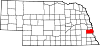
Villages Ghost towns Metropolitan area of Omaha-Council Bluffs Primary Cities NebraskaIowa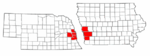
Cities over 10,000
(per 2000 Census)NebraskaCities of 5,000 to 10,000
(per 2000 Census)NebraskaIowaCities of 1,000 to 5,000
(per 2000 Census)NebraskaIowaCensus-designated places NebraskaCities and villages
of fewer than 1,000
(per 2000 Census)NebraskaAlvo · Avoca · Bennington · Boys Town · Cedar Bluffs · Cedar Creek · Ceresco · Colon · Elmwood · Fort Calhoun · Greenwood · Herman · Ithaca · Kennard · Leshara · Malmo · Manley · Mead · Memphis · Morse Bluff · Murdock · Murray · Nehawka · Prague · South Bend · Union · Valparaiso · Washington · Waterloo · WestonIowaCounties NebraskaIowaCategories:- Populated places in Cass County, Nebraska
- Villages in Nebraska


Wikimedia Foundation. 2010.