- Crescent, Iowa
-
Crescent, Iowa — City — Location of Crescent, Iowa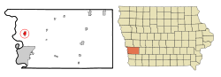
Coordinates: 41°21′49″N 95°51′32″W / 41.36361°N 95.85889°WCoordinates: 41°21′49″N 95°51′32″W / 41.36361°N 95.85889°W Country  United States
State  Iowa
IowaCounty Pottawattamie Area – Total 1.3 sq mi (3.3 km2) – Land 1.3 sq mi (3.3 km2) – Water 0.0 sq mi (0.0 km2) Elevation 1,010 ft (308 m) Population (2000) – Total 537 – Density 426.9/sq mi (164.8/km2) Time zone Central (CST) (UTC-6) – Summer (DST) CDT (UTC-5) ZIP code 51526 Area code(s) 712 FIPS code 19-17175 GNIS feature ID 0455709 Crescent is a city in Pottawattamie County, Iowa, United States. The population was 537 at the 2000 census.
Contents
Geography
Crescent is located at 41°21′49″N 95°51′32″W / 41.36361°N 95.85889°W (41.363656, -95.858789)[1].
According to the United States Census Bureau, the city has a total area of 1.3 square miles (3.4 km2), all of it land.
The city lies directly across the Mormon Bridge from North Omaha, and is located at the base of the Loess Hills. The Mount Crescent skiing area lies near the town, and is the nearest ski and snowboarding slope to the Omaha-Council Bluffs metropolitan area. In the summer the area serves as a recreational facility for activities such as paintball and cross-country running. Neighboring Hitchcock Park supports various types of wildlife and many miles of hiking trails.
History
Crescent was originally laid out by Joseph E. Johnson, a Latter-day Saint who also published a paper there in the 1850s. Before the near universal exodus of the Mormons to Utah in 1852 (many left beginning in 1847, but they were the majority of the population until 1852) the area was known as Brownell's Grove and Farmersville.[2]
Cresecent had about 300 residents in 1950.[3]
Demographics
As of the census[4] of 2000, there were 537 people, 192 households, and 153 families residing in the city. The population density was 426.9 people per square mile (164.6/km²). There were 195 housing units at an average density of 155.0 per square mile (59.8/km²). The racial makeup of the city was 98.32% White, 0.93% Native American, 0.19% Asian, and 0.56% from two or more races. Hispanic or Latino of any race were 0.19% of the population.
There were 192 households out of which 33.9% had children under the age of 18 living with them, 70.8% were married couples living together, 5.7% had a female householder with no husband present, and 20.3% were non-families. 15.6% of all households were made up of individuals and 6.3% had someone living alone who was 65 years of age or older. The average household size was 2.80 and the average family size was 3.15.
In the city the population was spread out with 25.9% under the age of 18, 8.8% from 18 to 24, 28.1% from 25 to 44, 27.4% from 45 to 64, and 9.9% who were 65 years of age or older. The median age was 37 years. For every 100 females there were 98.2 males. For every 100 females age 18 and over, there were 99.0 males.
The median income for a household in the city was $60,000, and the median income for a family was $61,042. Males had a median income of $32,917 versus $29,125 for females. The per capita income for the city was $24,548. About 3.1% of families and 2.5% of the population were below the poverty line, including none of those under age 18 and 11.1% of those age 65 or over.
References
- ^ "US Gazetteer files: 2010, 2000, and 1990". United States Census Bureau. 2011-02-12. http://www.census.gov/geo/www/gazetteer/gazette.html. Retrieved 2011-04-23.
- ^ BYU Winter Quarters website map
- ^ Columbia-Lippencott Gazeteer, p. 463
- ^ "American FactFinder". United States Census Bureau. http://factfinder.census.gov. Retrieved 2008-01-31.
Metropolitan area of Omaha-Council Bluffs Primary Cities NebraskaIowa
Cities over 10,000
(per 2000 Census)NebraskaCities of 5,000 to 10,000
(per 2000 Census)NebraskaIowaCities of 1,000 to 5,000
(per 2000 Census)NebraskaIowaCensus-designated places NebraskaCities and villages
of fewer than 1,000
(per 2000 Census)NebraskaAlvo · Avoca · Bennington · Boys Town · Cedar Bluffs · Cedar Creek · Ceresco · Colon · Elmwood · Fort Calhoun · Greenwood · Herman · Ithaca · Kennard · Leshara · Malmo · Manley · Mead · Memphis · Morse Bluff · Murdock · Murray · Nehawka · Prague · South Bend · Union · Valparaiso · Washington · Waterloo · WestonIowaCounties NebraskaIowaMunicipalities and communities of Pottawattamie County, Iowa Cities Avoca | Carson | Carter Lake | Council Bluffs | Crescent | Hancock | Macedonia | McClelland | Minden | Neola | Oakland | Shelby‡ | Treynor | Underwood | Walnut

Unincorporated
communityHoney Creek
Footnotes ‡This populated place also has portions in an adjacent county or counties
Categories:- Cities in Iowa
- Populated places in Pottawattamie County, Iowa
- Populated places established in the 1850s


Wikimedia Foundation. 2010.