- Birchington-on-Sea
-
Coordinates: 51°22′37″N 1°18′18″E / 51.377°N 1.3050°E
Birchington-on-Sea 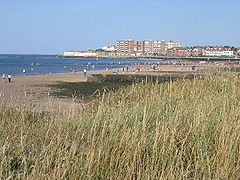
Minnis Bay
 Birchington-on-Sea
Birchington-on-Sea shown within KentPopulation 9,827 (2001 Census) OS grid reference TR298694 Parish Birchington District Thanet Shire county Kent Region South East Country England Sovereign state United Kingdom Post town BIRCHINGTON Postcode district CT7 Dialling code 01843 Police Kent Fire Kent Ambulance South East Coast EU Parliament South East England UK Parliament North Thanet List of places: UK • England • Kent Birchington-on-Sea is a village in northeast Kent, England, with a population of around 9,800. It is part of the Thanet district and forms the civil parish of Birchington. It lies on the coast facing the North Sea, east of the Thames Estuary, between the seaside resorts of Herne Bay and Margate.
As a seaside resort, the village is a notable tourist and retirement destination. The village's Minnis Bay is a family beach with attractions such as sailing, windsurfing, a paddling pool and coastal walking routes. Its three smaller beaches are surrounded by chalk cliffs, cliff stacks and caves.
The village was first recorded in 1240. Its parish church, All Saints, dates to the 13th century and its churchyard is the burial place of the 19th-century Pre-Raphaelite artist, Dante Gabriel Rossetti. Quex Park, a local 19th century manor house, is home to the Powell Cotton Museum and a twelve-bell tower built for change ringing. The museum contains a large collection of stuffed exotic animals collected by Major Powell-Cotton on his travels in Africa, and also houses artifacts unearthed in and around Birchington by his daughter, Antoinette Powell-Cotton, a keen archeologist.
Contents
History
Birchington was first recorded in 1240 as Birchenton, a name derived from the Old English words 'bircen tun', meaning a farm where birch trees grow.[1] Archaeological evidence has shown the area was inhabited before the existence of the village: Roman and prehistoric artefacts have been discovered in the area, and Minnis Bay was once the site of an Iron Age settlement.[2]
Archives show the village's All Saints Church dates to around 1350.[3] In the early 15th century, Quex Park manor house—named after the park's second owner, John Quek—was built just south of the village.[2] The ownership of the manor passed to various families until 1770 when it was acquired by the present owners, the Powell family.[4] In the late 17th century, the house was visited by King William III.[2] In 1565, a report on the coast of Thanet by the commissioners of Queen Elizabeth I stated that Birchington had 42 houses and did not have an active port.[5] Before the 19th century, the village coastline was frequented by smugglers, leading to skirmishes between them and excise officers. Several of the older houses in the village contain cellars and bricked up tunnels, once used for storing contraband.[2]
The 1801 census recorded the village's population as 537.[6] In the early 19th century, the Tudor Quex House had to be demolished and a replacement manor house was built in its place.[4] In 1818, the Waterloo Tower was built on the grounds of Quex Park. It is a bell tower built by the owner of Quex Park, John Powell Powell, who had an interest in change ringing. Waterloo Tower was the first twelve-bell tower in Kent.[7] The village was a farming community until the late 19th century, when it began to develop into a coastal resort. Birchington railway station was opened in 1863 and the Railway Hotel, now the Sea View Hotel pub, was opened in 1865. Station Road was subsequently built to serve as Birchington's main shopping street. Coast Guard cottages were built at Minnis Bay in the 1870s and the first shops appeared by the bay in 1903.[2]
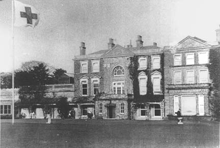
 Quex House as an Auxiliary Military Hospital during World War I
In 1896, Major P. H. G. Powell-Cotton founded the Powell Cotton Museum at Quex Park to display his collection of mammals and artefacts acquired on his expeditions to Africa and Asia.[8] The animals were mounted by the noted taxidermist Rowland Ward.[9] During World War I, Quex House became an Auxiliary Military Hospital run by the Birchington Voluntary Aid Detachment.[10] In 1923, the Memorial Ground was donated to the village by Mr H. A. Erlebach for sport and recreational use. Mr Erlebach owned the village's now defunct Woodfood House School and purchased land from the Quex House estate for the school. He gave the southern part of the land to the people of Birchington and dedicated it in memory of his three sons who had been killed in World War I. The land is now owned by Thanet District Council.[11]
Geography
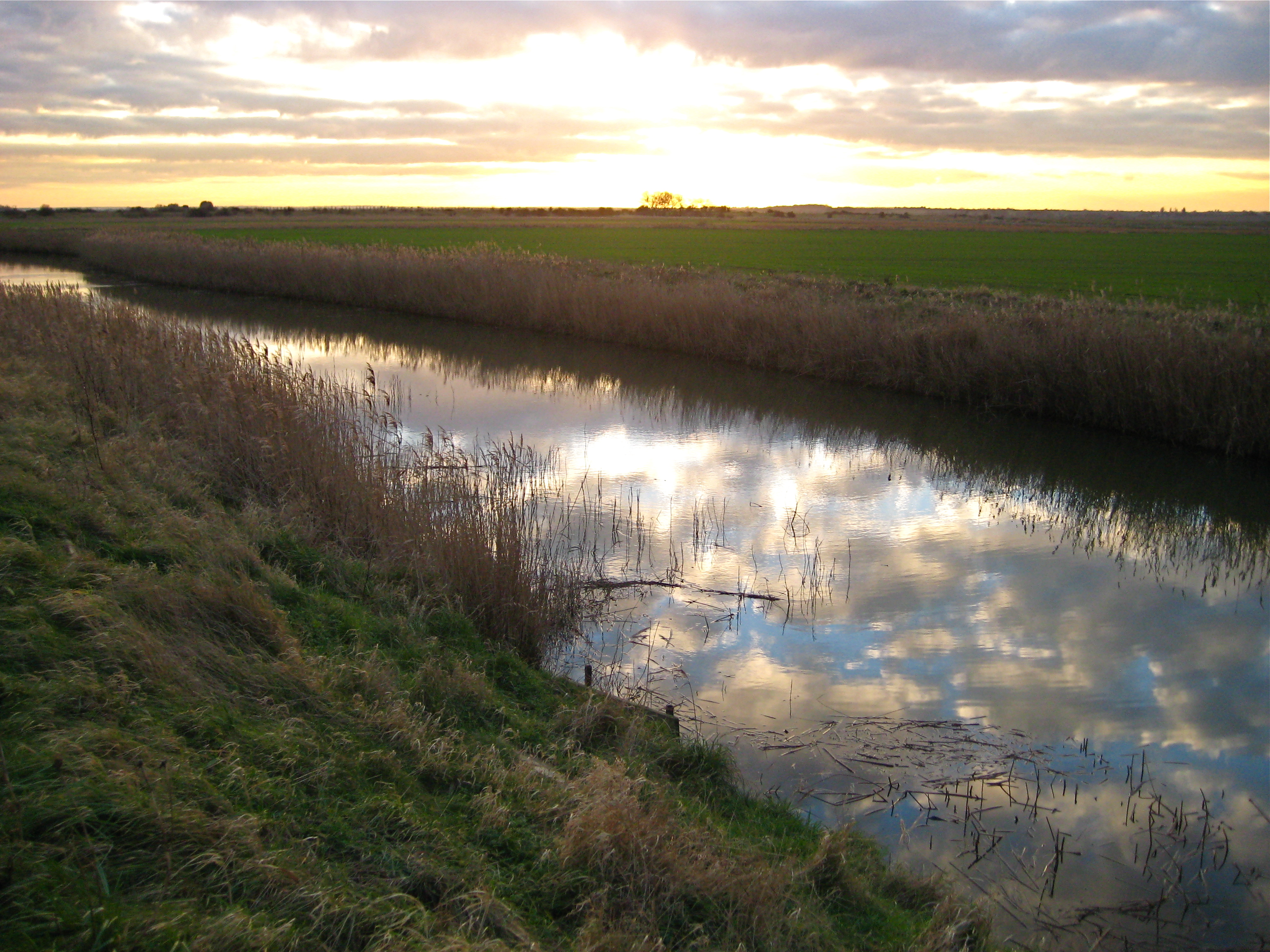
 A dyke in the Wantsum channel marshland, between Birchington-on-Sea and Herne Bay
Birchington-on-Sea is located at 51°22′37″N 1°18′18″E / 51.37694°N 1.305°E (51.377, 1.305) in northeast Kent, on the coast of the Thames Estuary. The village is 14 kilometres (9 mi) to the east of Herne Bay and 6 kilometres (4 mi) to the west of Margate. The small town of Westgate-on-Sea lies between Birchington and Margate. The village/civil parish of Acol is 2 kilometres (1 mi) to the south and the villages/civil parishes of St Nicholas at Wade and Sarre are 5 kilometres (3 mi) to the southwest.
Neighbouring towns, parishes & seas. 
Thames Estuary (sea) Thames Estuary (sea) Thames Estuary (sea) Herne Bay (town) 
Westgate-on-Sea (town)  Birchington-on-Sea

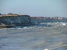
St Nicholas at Wade with Sarre (civil parish) Acol (civil parish) Manston (civil parish) The village is built beside four sandy bays; Minnis Bay to the west, Grenham Bay and Beresford Gap towards the centre and Epple Bay to the east. The village is situated on the Isle of Thanet, which was a separate island from mainland Kent until around two hundred years ago, when the channel in between became silted up. The area to the west of the village, between Birchington and Herne Bay, was once part of the channel and is now low-lying marshland. In the east of the village the land rises, forming chalk cliffs and cliff stacks around the beaches at Grenham Bay, Beresford Gap and Epple Bay. A sea wall stretches along the foot of the cliffs to prevent further erosion. The geology of Thanet consists mainly of chalk, deposited when the area was below the sea. Isle of Thanet became exposed above sea-level once the English Channel broke through between Kent and France, causing the sea-level to fall.[12] The whole of the northeast Kent coast has been designated a Site of Special Scientific Interest.[13]
The drinking water in the village is classed as being 'very hard', having just over 120 mg of calcium per litre. The hardness is due to water being obtained from underground chalk sources by the water company Southern Water.[14] Waste water is discharged into the sea after being treated at a sewage works in Margate.
Climate
In East Kent, the warmest time of the year is July and August, when maximum temperatures average around 21 °C (70 °F). The coolest time of the year is January and February, when minimum temperatures average around 1 °C (34 °F).[15] East Kent's average maximum and minimum temperatures are around 1/2 °C higher than the national average.[16] East Kent's average annual rainfall is about 728 millimetres (29 in), with October to January being the wettest months.[15] The national average annual rainfall is about 838 millimetres (33 in).[16]
These are average temperature and rainfall figures taken between 1971 and 2000 at the Met Office weather station in Wye, around 24 miles (39 km) southwest of Birchington:
Climate data for Wye Weather Station, Wye, Kent, England Month Jan Feb Mar Apr May Jun Jul Aug Sep Oct Nov Dec Year Average high °C (°F) 7.1
(44.8)7.2
(45.0)9.9
(49.8)12.1
(53.8)15.9
(60.6)18.7
(65.7)21.3
(70.3)21.6
(70.9)18.4
(65.1)14.5
(58.1)10.3
(50.5)8.0
(46.4)13.8 Average low °C (°F) 1.5
(34.7)1.3
(34.3)2.8
(37.0)4.3
(39.7)7.3
(45.1)9.9
(49.8)12.2
(54.0)12.2
(54.0)10.1
(50.2)7.2
(45.0)3.9
(39.0)2.6
(36.7)6.3 Precipitation mm (inches) 72.0
(2.835)44.7
(1.76)53.5
(2.106)50.8
(2)45.3
(1.783)51.8
(2.039)47.1
(1.854)55.9
(2.201)65.3
(2.571)85.4
(3.362)78.7
(3.098)77.3
(3.043)727.9
(28.657)Source: Met Office[17] Transport links
 A view of Birchington-on-Sea from the neighbouring town of Westgate-on-Sea
Birchington-on-Sea railway station is on the Chatham Main Line which runs between Ramsgate in East Kent and London Victoria. Other stations on this line include Broadstairs, Margate, Herne Bay, Faversham, Gillingham, Chatham, Rochester and Bromley South.[18] Birchington is around 1 hour and 45 minutes from London by fast-service train. A National Express coach service also runs between London Victoria and Ramsgate via Birchington-on-Sea.[19] A selection of trains run to London's Cannon Street station, primarily for business commuting.
There are Stagecoach bus services running to Westgate-on-Sea, Margate, Broadstairs, Canterbury and Herne Bay. The A28 road runs between Hastings and Margate via Ashford, Canterbury, Birchington and Westgate-on-Sea. 3 miles (5 km) southwest of Birchington-on-Sea, the A28 crosses the A299 road which leads along North Kent towards London, becoming the M2 motorway at Faversham.[20]
Demography
Birchington-on-Sea Compared 2001 UK census Birchington Thanet England Total population 9,827 126,702 49,138,831 Foreign born 4.5% 5.1% 9.2% White 98% 98% 91% Asian 0.7% 0.6% 4.6% Black 0.2% 0.3% 2.3% Christian 80% 74% 72% Muslim 0.6% 0.5% 3.1% Hindu 0.1% 0.2% 1.1% No religion 11% 16% 15% Bachelor's degree or higher 15% 13% 20% Over 65 years old 36% 22% 16% Unemployed 2.5% 4.4% 3.3% As of the 2001 UK census, the village had 9,827 residents. It is claimed to be "Kent's largest village",[21] although this is unofficial as there is no common definition in the UK of a village.
The village had 4,742 households, of which 47.9% were married couples living together, 5.3% were cohabiting couples and 6.8% were lone parents. 35.3% of all households were made up of individuals and 26.9% had someone living alone at pensionable age. 18.0% of households included children aged under 16 or a person aged 16 to 18 who was in full-time education.[22]
The ethnicity of the village was predominately white with over 95% of its residents being born in the United Kingdom and 2% in other Western Europe countries. About 80% of residents claimed to be Christian, 0.6% Muslim, and less than 1% either Buddhist, Jewish, Hindu or an alternative religion, while 7% did not state their religion, and 11% claimed no religious affiliation.[22]
For every 100 females, there were 80.2 males. The age distribution was 4% aged 0–4 years, 10% aged 5–15 years, 3% aged 16–19 years, 21% aged 20–44 years, 26% aged 45–64 years and 36% aged 65 years and over. The village had a very high percentage of residents over 65, compared with the national average of 16%.[22] As a seaside resort, Birchington-on-Sea is a popular retirement destination.
Economy
As of the 2001 UK census, the economic activity of residents in the village aged 16–74 was 30.3% in full-time employment, 10.9% in part-time employment, 8.8% self-employed, 2.5% unemployed, 1.6% students with jobs, 2.5% students without jobs, 29.4% retired, 6.1% looking after home or family, 5.5% permanently sick or disabled and 2.3% economically inactive for other reasons. The percentage of retired people was significantly higher than the national figure of 14%. 15% of the village's residents aged 16–74 had a higher education qualification or the equivalent, compared to 20% nationwide.[22] According to Office for National Statistics estimates, during the period of April 2001 to March 2002 the average gross weekly income of households in the Birchington-on-Sea electoral wards was £460 (£23,986 per year).[22]
The industry of employment of residents was 16% retail, 14% health and social work, 11% manufacturing, 11% education, 10% real estate, 9% construction, 7% transport and communications, 6% public administration, 5% hotels and restaurants, 3% finance, 2% agriculture, 1% energy and water supply, and 5% other community, social or personal services. Compared to national figures, the village had a relatively high number of workers in the construction and health/social care industries and a relatively low number in finance and manufacturing.[22] Many residents commute to work outside the town; as of the 2001 census, the town had 3,370 employed residents, but only 1,711 jobs.[22]
As a seaside resort, the village has an economy based around tourism, with several hotels, caravan parks and leisure attractions. The village shopping centre attracts walk-in trade from tourists.[23] One of the largest retailers is the Somerfield supermarket. The elderly population of the village has generated health and social care jobs at local care homes and at the Birchington Medical Centre. As of the 2001 census, 1.4% of the village's population resided in a medical or care establishment, compared to the national average of only 0.8%.[22]
Culture
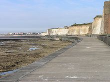 Birchington-on-Sea's Epple Bay, with sea wall and promenade
Minnis Bay is a popular family beach with attractions such as sailing, windsurfing, cafes, beach huts, public houses, restaurants, a paddling pool and coastal walking/cycling routes. The beach has gained a European Blue Flag Award for its cleanliness and safety.[24] The village has three other smaller beaches, which are surrounded by chalk cliffs and cliff stacks. The Thanet Coast Project runs trips out of the bay in July and August to observe the wildlife of the Thames Estuary including seals, velvet swimming crabs and the migrant Turnstone.[25]
To the south of the village is Quex House, a 200 year-old manor house situated in 250 acres (1.0 km2) of parkland and gardens. Several rooms, decorated with oriental and English period furniture, are open to visitors, and guided tours are provided.[26] The Powell Cotton Museum houses three galleries of stuffed animal displays, depicting more than 500 African and Asian animals against their natural habitats.[9] Further galleries display a vast collection of African artefacts, European firearms, European and Asian cutting weapons, European and Chinese porcelain, and important archaeological finds from Thanet and East Kent.[8]
Paintings by local artists are displayed at the Burley Gallery in Birchington Library.[27] Community activities take place at the Birchington Village Centre, including adult education classes, drama productions by the Birchington Guild of Players and concerts by the Birchington Silver Band. In 1989, Birchington-on-Sea was twinned with the town of La Chapelle d`Armentieres, near Lille in northern France;[28] Birchington Twinning Association arranges events between the two communities, such as school trips, concerts and war remembrance services.[29] Since 1932, Birchington has held a street carnival each summer.[30]
As a seaside resort, the village has several clubs for watersports.[31] Minnis Bay Sailing Club, founded in 1950, is a dinghy and catamaran club where members can sail for fun, but competitions are also held most weekends.[32] Speed boats, jet skis and water skis can be hired for use near the beach at Beresford Gap by members of Beresford Wakeboard and Water Ski Club, which was established in 2004 to help alleviate anti-social behaviour in the area.[33][34] Anglers are catered for by Birchington Sea Angling Society.
Several teams compete in local leagues: the Birchington United Services Club runs a football team in the Thanet Sunday Football League Premier Division[35] and a netball team in the Thanet and District Netball League,[36] while Birchington Chess Club competes in the Thanet League. Westgate and Birchington Golf Club has an 18-hole 4,889-yard (4,471 m) course on the cliff tops between Westgate and Birchington.[37] Birchington Bridge Club meets twice a week at the Our Lady and St Benedict's Church Hall.[38] A football pitch is provided at the council owned Birchington Recreation Ground.[39]
There are four local weekly newspapers providing news on the Thanet district area. Isle Of Thanet KM Extra and Thanet Adscene are free newspapers, while Isle of Thanet Gazette and Thanet Times are paid-for. Isle Of Thanet KM Extra is owned by the KM Group,[40] Isle of Thanet Gazette, Thanet Adscene and Thanet Times are owned by Trinity Mirror.[41] There are two local newsmagazines produced for the people of Birchington: The Birchington Roundabout, which began publishing in April 2003,[42] and The Birchington Forum. KMFM Thanet is a radio station on frequency 107.2FM, owned by the KM Group.[43] Community radio station Academy FM (Thanet) launched in 2010 on 107.8FM.
Notable residents have included the British screenwriter Tudor Gates, who wrote a number of female vampire stories for Hammer Studios in the early 1970s. Gates died in the village in January 2007.[44] In early 1882, Pre-Raphaelite artist and poet Dante Gabriel Rossetti rented a bungalow in the village, in an attempt to recuperate from ill-health. However, he died in April the same year and was buried in the churchyard of All Saints, under a tombstone designed by fellow artist, Ford Madox Brown.[45]
Politics
Since 1983, the Member of Parliament for North Thanet, covering northern Thanet and Herne Bay, has been the Conservative Roger Gale. At the 2005 general election, in North Thanet the Conservatives won a majority of 7,634 and 49.6% of the vote. Labour won 32.2% of the vote, Liberal Democrats 14.4% and United Kingdom Independence Party 3.9%.[46] Birchington-on-Sea is in the Thanet local government district. The village's electoral wards of Birchington North and Birchington South have five of the fifty six seats on the Thanet District Council. As of the 2007 local elections, all five of those seats were held by the Conservative Party.[47] The village has its own civil parish, the lowest unit of local government. Birchington Parish Council has ten members and deals with issues specifically affecting Birchington.[48]
Education
See also: List of schools in KentBirchington-on-Sea's secondary school is the secondary modern King Ethelbert School. As of 2006, it had around 750 pupils and was seeking government support to become a specialist visual arts school.[49] In 2005, 15 percent of its pupils gained at least five GCSEs at grades A*–C including English and maths, ranking it 103rd out of 120 Kent secondary schools.[50] The school failed the 30% GCSE target.[51][52] Many secondary students living in Birchington-on-Sea commute to schools in nearby towns, especially to the grammar schools in Ramsgate and Broadstairs. The village's primary school is Birchington Church of England Primary School,[53] which is a state school owned by the Church of England but run by Kent County Council.[54] In 2006, the school's Key Stage 2 performances ranked 340th out of 386 Kent state primary schools.[55]
References
- ^ "Kent place names". BBC. http://www.bbc.co.uk/kent/places/names/names_b.shtml. Retrieved 2007-04-24.
- ^ a b c d e Mirams, Michael (1984). Old Margate. Maresborough Books.
- ^ "Archival information". BirchingtonHeritage.org.uk. http://www.birchingtonheritage.org.uk/archive.htm. Retrieved 2007-05-29.
- ^ a b "Powell-Cotton Manuscripts". Access to Archives. http://www.a2a.org.uk/html/2006-r-u1063.htm. Retrieved 2007-03-29.
- ^ Scurrell, David (1982). The Book of Margate. Barracuda Books.
- ^ "Potted Histories" (PDF). The Birchington Roundabout. October 2003. Archived from the original on October 1, 2006. http://web.archive.org/web/20061001091419/http://www.thebirchingtonroundabout.co.uk/documents/Octoberroundaboutwithoutadverts.PDF. Retrieved 2007-06-23.
- ^ "Waterloo Tower". QuexMuseum.org. Archived from the original on 2007-09-27. http://web.archive.org/web/20070927050155/http://www.quexmuseum.org/gardens/tower.htm. Retrieved 2007-05-28.
- ^ a b "Museum". QuexMuseum.org. http://www.quexmuseum.org/museum/museum.htm. Retrieved 2007-05-28.
- ^ a b "Animals". QuexMuseum.org. http://www.quexmuseum.org/museum/animals.htm. Retrieved 2007-05-28.
- ^ "Quex Park Auxiliary Military Hospital". VLib.us. http://www.vlib.us/medical/quexhosp/quex.htm. Retrieved 2007-05-29.
- ^ "Erlebach Legacy Could Become Focus For Village Health and Recreation" (PDF). TheBirchingtonRoundabout.co.uk. Archived from the original on March 12, 2007. http://web.archive.org/web/20070312004843/http://www.thebirchingtonroundabout.co.uk/documents/Febuaury2007webversion.pdf. Retrieved 2007-05-29.
- ^ "Isle of Thanet". BBC. http://www.bbc.co.uk/kent/content/articles/2006/05/15/thanet_history_feature.shtml. Retrieved 2007-03-29.
- ^ "Geological Sites Map". Natureonthemap.org.uk. http://www.natureonthemap.org.uk/map.aspx. Retrieved 2007-04-24.
- ^ "Drinking water quality". Southern Water. http://www.southernwater.co.uk/homeAndLeisure/whereILive/default.asp. Retrieved 2007-06-21.
- ^ a b "Wye 1971-2000 averages". Met Office. http://www.metoffice.gov.uk/climate/uk/averages/19712000/sites/wye.html?s=043330&refer=. Retrieved 2007-03-29.
- ^ a b "England 1971-2000 averages". Met Office. http://www.metoffice.gov.uk/climate/uk/averages/19712000/areal/england.html. Retrieved 2007-03-29.
- ^ "Wye 1971-2000 averages". UK government. http://www.metoffice.gov.uk/climate/uk/averages/19712000/sites/wye.html?s=043330&refer=. Retrieved January 9, 2008.
- ^ "Timetable". National Rail Enquiries. http://ojp2.nationalrail.co.uk/en/pj/tt. Retrieved 2007-03-29.
- ^ "Timetable". National Express. http://www.nationalexpress.com/bp/b2.cfm?id=84618113. Retrieved 2007-03-29.
- ^ "Map". Yahoo.com. http://maps.yahoo.com/broadband/#mvt=m&q1=51.3832,1.3353&trf=0&lon=1.261196&lat=51.359241&mag=6. Retrieved 2007-03-29.
- ^ "Birchington Parish Council". Birchington Parish Council. http://www.birchington.org/. Retrieved 2007-03-29.
- ^ a b c d e f g h "Neighbourhood Statistics". Statistics.gov.uk. http://neighbourhood.statistics.gov.uk/dissemination/LeadHome.do;jsessionid=ac1f930bce6a711447e60ba4446bb56c21648d42c51.e38PbNqOa3qRe38OaNeKahqMai1ynknvrkLOlQzNp65In0?bhcp=1. Retrieved 2007-03-29.
- ^ "Isle of Thanet Local Plan 1998" (PDF). Thanet District Council. April 1998. http://www.thanet.gov.uk/PDF/ADPTDPLAN.pdf. Retrieved 2007-03-29.
- ^ MinnisBay "Minnis Bay". BlueFlag.org. http://www.blueflag.org/blueflag/2006/UnitedKingdom/SouthEast/Birchington, MinnisBay. Retrieved 2007-04-24.
- ^ "Unique opportunity to get close to Thanet's seals". Thanet City Council. http://www.thanet.gov.uk/news/press_releases/press_release_archive/get_close_to_thanets_seals.aspx. Retrieved 2007-04-24.[dead link]
- ^ "Quex Museum". QuexMuseum.org. Archived from the original on 2007-09-27. http://web.archive.org/web/20070927050137/http://www.quexmuseum.org/index.htm. Retrieved 2007-05-28.
- ^ "Art exhibition at Birchington Library". Kent County Council. 2006-09-06. http://www.kent.gov.uk/news/sep-06-burley-gallery.htm. Retrieved 2007-04-24.[dead link]
- ^ "La Chapelle D'Armentieres" (in French). Ville-La-Chapelle-D-Armentieres.fr. Archived from the original on November 24, 2006. http://web.archive.org/web/20061124184637/http://www.ville-la-chapelle-d-armentieres.fr/rubrique.php3?id_rubrique=1. Retrieved 2007-03-29.
- ^ "Village News". Birchington Parish Council. http://www.birchington.org/Parish/breaknews.htm. Retrieved 2007-03-29.
- ^ "71 years of Carnival Fun" (PDF). The Birchington Roundabout. August 2003. Archived from the original on October 1, 2006. http://web.archive.org/web/20061001092808/http://www.thebirchingtonroundabout.co.uk/documents/Augustroundaboutwithoutadverts.PDF. Retrieved 2007-06-23.
- ^ "Sport Directory" (PDF). Thanet District Council. November 2006. http://www.thanet.gov.uk/pdf/Thanet%20District%20Council%20Sports%20Directory_4dec06.pdf. Retrieved 2007-04-24.
- ^ "Minnis Bay Sailing Club". Minnis Bay Sailing Club. http://www.minnisbaysailingclub.co.uk/index.html. Retrieved 2007-05-29.
- ^ "Water Based Recreation" (DOC). ThanetCoast.org.uk. http://www.thanetcoast.org.uk/docs/4_Water_Based_Recreation_0407.doc. Retrieved 2007-06-05.
- ^ "Designated Launching facilities in Thanet". Thanet District Council. Archived from the original on 2007-10-06. http://web.archive.org/web/20071006234835/http://www.thanet.gov.uk/environment__planning/water_users_group/designated_launching_facilitie.aspx. Retrieved 2007-04-23.
- ^ "Birchington United Services Club". Webteams.co.uk. http://www.webteams.co.uk/_2006/Home.asp?team=birchingtonusc. Retrieved 2007-04-23.
- ^ "Thanet and District Netball League". Thanet and District Netball League. http://www.thanetnetballleague.co.uk/index.php?tab=fixtures&PHPSESSID=628bc3357123515b0b3121af641909c4. Retrieved 2007-06-05.
- ^ "Westgate and Birchington Golf Club". GolfLinks.co.uk. http://www.golflinks.co.uk/golf-course/golf-club/1594/westgate+and+birchington+golf+club.html. Retrieved 2007-05-29.
- ^ "The Island Guide" (PDF). KentandMedway.nhs.uk. Archived from the original on March 10, 2006. http://web.archive.org/web/20060310205403/http://www.kentandmedway.nhs.uk/pdf/Your_health/The_Island_Guide2nd_ed.pdf. Retrieved 2007-05-29.
- ^ "Outdoor Sports Pitches". Thanet Leisure Force. http://www.tlfleisure.co.uk/outdoor/outdoor/default.asp. Retrieved 2007-06-21.
- ^ "KM Publications". Kent Online. http://www.kentonline.co.uk/km/publications/. Retrieved 2007-04-14.
- ^ "Regionals". Trinity Mirror. http://www.trinitymirror.com/brands/regionals/southern/tms/. Retrieved 2007-04-14.
- ^ "The Birchington Roundabout". The Birchington Roundabout. http://www.thebirchingtonroundabout.co.uk/. Retrieved 2007-06-07.
- ^ "kmfm". MediaUK.com. http://www.mediauk.com/radio/229/kmfm-%28thanet%29. Retrieved 2007-04-14.
- ^ "Tudor Gates". The Stage. 2007-01-30. http://www.thestage.co.uk/features/obituaries/feature.php/15756/tudor-gates. Retrieved 2007-05-28.
- ^ "Rossetti Archive Textual Transcription". RossettiArchive.org. http://www.rossettiarchive.org/docs/pr5246.a43.rad.html. Retrieved 2007-05-28.
- ^ "North Thanet". London: Guardian.co.uk. http://politics.guardian.co.uk/hoc/constituency/0,,-1183,00.html. Retrieved 2007-03-29.
- ^ "2007 Election results". Thanet District Council. 2007. Archived from the original on 2007-05-18. http://web.archive.org/web/20070518075104/http://www.thanet.gov.uk/news/latest_press_releases/election_results_04-05-07.aspx. Retrieved 2007-03-29.
- ^ "About the Birchington Parish Council". Birchington Parish Council. http://www.birchington.org/Parish/aboutus.htm. Retrieved 2007-03-29.
- ^ "King Ethelbert School". King Ethelbert School. 2007-05-03. http://www.kingethelbert.kent.sch.uk/art.htm. Retrieved 2007-04-15.
- ^ "Schools in Kent". BBC. 2005-10-19. http://news.bbc.co.uk/1/shared/bsp/hi/education/04/school_tables/secondary_schools/html/886_gcse_lea.stm. Retrieved 2007-04-24.
- ^ "Schools below 30% GCSE target". BBC News. 2008-06-09. http://news.bbc.co.uk/1/hi/education/7444059.stm. Retrieved 2010-04-26.
- ^ "BBC News, School league tables 2007, Kent LA". BBC News. http://news.bbc.co.uk/1/shared/bsp/hi/education/07/school_tables/secondary_schools/html/886_4120.stm. Retrieved 2010-04-26.
- ^ "UK Schools & Colleges Database". Schoolswebdirectory.co.uk. http://www.schoolswebdirectory.co.uk/postcode.php?searchword=ct7&action=Search. Retrieved 2007-03-29.
- ^ "Schools and the Church of England". Church of England. 2004. http://www.cofe.anglican.org/info/education/schools/. Retrieved 2007-03-29.
- ^ "Primary schools in Kent". BBC. 2006-12-07. http://news.bbc.co.uk/1/shared/bsp/hi/education/06/school_tables/primary_schools/html/agg_886.stm. Retrieved 2007-03-29.
External links
Listen to this article (info/dl)
 This audio file was created from a revision of Birchington-on-Sea dated 2008-03-09, and does not reflect subsequent edits to the article. (Audio help)More spoken articles
- Birchington Parish Council
- Birchington Heritage Trust
- Books on Birchington
- The Waterloo Tower, Quex Park
- Clubs and societies in Thanet
Towns and villages in the Thanet district of Kent, England 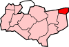
Unparished areas Civil parishes Other settlements - Broadstairs
- Brooks End
- Cliftonville
- Ebbsfleet
- Flete
- Garlinge
- Newington
- Palm Bay
- Sevenscore
- St Peters
- Westbrook
- Westgate-on-Sea
- Westwood
List of places in Kent Ceremonial county of Kent Kent Portal Unitary authorities Boroughs or districts Major settlements Ashford, Broadstairs, Canterbury, Chatham, Cranbrook, Dartford, Deal, Dover, Edenbridge, Faversham, Folkestone, Fordwich, Gillingham, Gravesend, Greenhithe, Herne Bay, Hythe, Lydd, Maidstone, Margate, Minster, New Romney, Northfleet, Paddock Wood, Queenborough, Rainham, Ramsgate, Rochester, Royal Tunbridge Wells, Sandwich, Sevenoaks, Sheerness, Sittingbourne, Snodland, Southborough, Strood, Swanley, Swanscombe, Tenterden, Tonbridge, Walmer, West Malling, Westerham, Westgate-on-Sea, Whitstable
See also: List of civil parishes in KentRivers See: Rivers of KentTopics Categories:- Thanet
- Villages in Kent
- Civil parishes in Kent
- Populated coastal places in Kent


Wikimedia Foundation. 2010.