- Old Plantation Flats Light
-
Old Plantation Flats Light 
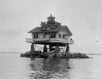
Undated photograph of Old Plantation Flats Light (USCG) Location In the Chesapeake Bay west of Cape Charles, Virginia Coordinates 37°13′44″N 76°02′49″W / 37.2288°N 76.0469°W
replica at 37°14′39″N 76°01′04″W / 37.2441°N 76.0179°WYear first lit 1886 Deactivated 1962 Foundation screw-pile Construction cast-iron/wood/concrete Tower shape square house Height 35 ft Original lens fifth-order Fresnel lens Range 11 mi Characteristic Flashing 4 sec The Old Plantation Flats Light was a lighthouse located in the Chesapeake Bay marking the channel to Cape Charles, Virginia.
History
Old Plantation Flats is a shoal paralleling the Eastern Shore near the mouth of the bay, taking its name from Old Plantation Creek which empties into the bay near the center of the shoal. A square screw-pile light was erected on the shoal in 1886. It was constantly plagued by ice floes, with the original lens being destroyed in 1893, and more substantial damage done in 1918. After the latter the piles were reinforced with concrete and surrounded with rip-rap. The resulting structure was unlike any other in the bay.
In the 1890s the Pennsylvania Railroad established Cape Charles, Virginia as the southern terminus of its Eastern Shore rail system. The Corps of Engineers dredged out a lagoon and created a channel running across the flats, with the light serving to mark its entrance. This channel allowed the railroad to connect to points west through car float operations.
In 1962 the house was removed from the light and replaced with the usual skeleton tower. However in 2004 a replica was constructed as part of the Bay Creek Resort and Club being built south of Cape Charles. This replica includes a 1940s-era fog bell taken from a retired buoy and a new fourth-order lens, the first constructed in eighty years. Another half size replica sits astride a golf cart causeway, forming a sort of covered bridge.
References
- "Historic Light Station Information and Photography: Virginia". United States Coast Guard Historian's Office. http://www.uscg.mil/history/weblighthouses/LHVA.asp.
- Old Plantation Flats Light, from the Chesapeake Chapter of the United States Lighthouse Society
- de Gast, Robert (1973). The Lighthouses of the Chesapeake. Johns Hopkins University Press. p. 170.
- "Old Plantation Flats Light Station Replica". Bay Creek Resort & Club. http://www.baycreekgolfclub.com/plantationflats.asp.
- Thomas, William G. III; Brooks Miles Barnes, Tom Szuba (31 July 2007). "The Countryside Transformed: The Eastern Shore of Virginia, the Pennsylvania Railroad, and the Creation of a Modern Landscape". Southern Spaces. http://southernspaces.org/2007/countryside-transformed-eastern-shore-virginia-pennsylvania-railroad-and-creation-modern-landsc. Retrieved 2007-11-11.
 Categories:
- Lighthouses in Virginia
- Buildings and structures completed in 1886
- Buildings and structures in Northampton County, Virginia
- Transportation in Northampton County, Virginia
Wikimedia Foundation. 2010.