- Chesapeake Light
-
Chesapeake Light 
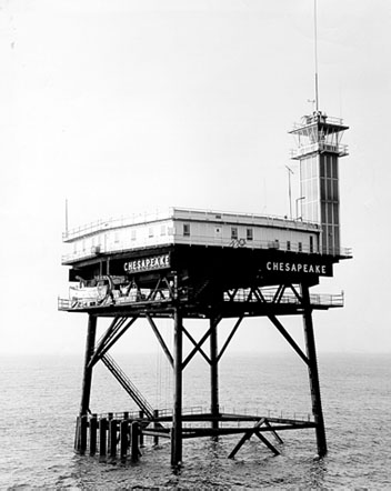
Undated photograph of Chesapeake Light (USCG) 

Location 16 mi east of Cape Henry, Virginia Coordinates 36°54′17″N 75°42′46″W / 36.90472°N 75.71278°WCoordinates: 36°54′17″N 75°42′46″W / 36.90472°N 75.71278°W[1] Year first lit 1965 Automated 1980 Foundation Four black piles Construction prefabricated modules Tower shape White square platform with tower at one corner Height 120 ft Range 24 miles Characteristic Fl(2) W 15s Chesapeake Light is an offshore lighthouse marking the entrance to the Chesapeake Bay. Once considered for decommissioning, it remains active and supports a NOAA weather data site.
Contents
History
This station was first established in 1930 using a lightship, since lighthouse construction technology at the time was not adequate to the task of supporting a light in such waters. It remained on station (except during World War II) until it was replaced by the present light, built in 1965 as one of six nearly identical "Texas Tower" lights on the East Coast. The United States lightship Chesapeake (LV-116) which formerly was used at the site is now on display at the Inner Harbor in Baltimore, MD.
The light was automated in 1980, though it was used in 2002-2003 by University of Maryland, Baltimore County students for research projects. The following year it was inspected by the Coast Guard with an eye toward dismantling it, as had happened earlier to the Ambrose and Savannah lights, both of which had been struck by ships. The inspection showed the light to be sound, and the light remains in active service. This makes Chesapeake Light the only Texas Tower still in use.
See also
- Lightship Chesapeake
References
- ^ (PDF) Light List, Volume II, Atlantic Coast, Shrewsbury River, New Jersey to Little River, South Carolina. Light List. United States Coast Guard. 2007. http://www.navcen.uscg.gov/pdf/lightLists/LightList%20V2.pdf.
- "Chesapeake “Texas Tower” Timeline" (PDF). United States Lighthouse Society, Chesapeake Chapter. http://www.cheslights.org/heritage/timeline/ChesTowerTimeline.pdf. Retrieved 2008-01-16.
- "Historic Light Station Information and Photography: Virginia". United States Coast Guard Historian's Office. http://www.uscg.mil/history/weblighthouses/LHVA.asp.
- "National Data Buoy Center: Station CHLV2 - Chesapeake Light, VA". NOAA. http://www.ndbc.noaa.gov/station_page.php?station=chlv2. Retrieved 2008-01-16.
External links
- Chesapeake Bay Lighthouse Project - Chesapeake Light Station
- Chesapeake Bay Lighthouse Project - Lightship Chesapeake
 Categories:
- Lighthouses in Virginia
- Buildings and structures completed in 1965

Wikimedia Foundation. 2010.