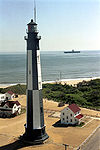
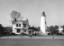
- Old Point Comfort Light
-
Old Point Comfort Light Old Point Comfort Light and keeper's house (USCG) Location On the grounds of Fort Monroe Coordinates 37°00′06″N 76°18′23″W / 37.00178°N 76.30643°WCoordinates: 37°00′06″N 76°18′23″W / 37.00178°N 76.30643°W Year first lit 1802[citation needed] Automated 1972 Construction sandstone masonry Tower shape Octagonal tower Height 58 ft Original lens fourth order Fresnel lens Range 13 miles Characteristic 12 sec double flash red Old Point Comfort LighthouseLocation: Fenwick Rd., SW of E gate of Fort Monroe, Hampton, Virginia Coordinates: 37°0′6″N 76°18′25″W / 37.00167°N 76.30694°W Area: 9.9 acres (4.0 ha) Built: 1802 Part of: Fort Monroe Historic District (#66000912) NRHP Reference#: 73002212 [1] Significant dates Added to NRHP: March 01, 1973 Designated NHLDCP: October 15, 1966 Old Point Comfort Light is a lighthouse located on the grounds of Fort Monroe in the Virginia portion of the Chesapeake Bay. It is the second oldest light in the bay and the oldest still in use.
History
Records of aids to navigation at Old Point Comfort date to 1775, when John Dams was paid to maintain a beacon there. Its location at the entrance to Hampton Roads made it one of the first points designated for a light by the new United States federal government, and appropriations were made starting in 1800. The light was constructed by Elzy Burroughs and put into service in 1803, though a keeper's house was not built until 1823.
In the War of 1812 the light was one of several seized by British forces in their advance on Washington, DC. Following the war, Fort Monroe was constructed on the point, situated so that its walls were a short distance from the light. In the Civil War it escaped damage and extinguishing, as Fort Monroe was held by Union forces throughout. By this time the original lamp and reflector arrangement had given way to a Fresnel lens. Following the war consideration was made of deactivating the light, as development around the point had made it less conspicuous. The light was retained, however, and a program of improvements to the grounds and facilities toward the end of the century culminated in the replacement of the keeper's house with a new structure in 1891.
A variety of upgrades and innovations were applied to the light in the early twentieth century, including an experimental photoelectric control for the fog signal installed in 1936. The characteristic was altered several times as well. Red sectors in the lantern glass showed a white sector until the entire signal was made flashing red.
Upon automation in 1973 the keeper's house was transferred to the Army, which continues to use it as an officer's dwelling. The lantern is painted in an unusual combination of a red roof and green rails, decking, and walls. The light continues in use.
References
- ^ "National Register Information System". National Register of Historic Places. National Park Service. 2010-07-09. http://nrhp.focus.nps.gov/natreg/docs/All_Data.html.
- "Historic Light Station Information and Photography: Virginia". United States Coast Guard Historian's Office. http://www.uscg.mil/history/weblighthouses/LHVA.asp.
- Inventory of Historic Light Stations - Virginia Lighthouses: Old Point Comfort Light from National Park Service
- Old Point Comfort Lighthouse, Virginia from LighthouseFriends.com
- de Gast, Robert (1973). The Lighthouses of the Chesapeake. Baltimore: Johns Hopkins University Press. pp. 26–29.
External links
 Categories:
- Historic district contributing properties
- Lighthouses in Virginia
- National Register of Historic Places in Virginia
- Buildings and structures in Hampton, Virginia
- Lighthouses on the National Register of Historic Places
- Buildings and structures completed in 1803
Wikimedia Foundation. 2010.


