- Cherrystone Bar Light
-
Cherrystone Bar Light Location SW of Cape Charles, Virginia harbor in the Chesapeake Bay Coordinates 37°15′23″N 76°01′57″W / 37.2564°N 76.0324°WCoordinates: 37°15′23″N 76°01′57″W / 37.2564°N 76.0324°W Year first lit 1858 Deactivated 1919 Foundation screw-pile Construction cast-iron/wood Tower shape hexagonal house Original lens fourth-order Fresnel lens The Cherrystone Bar Light was a lighthouse located at the entrance to Cape Charles, Virginia harbor in the Chesapeake Bay. It was the only light in the bay moved to another location, becoming the Choptank River Light in 1921.
History
This light was constructed shortly before the Civil War, and as with other Virginia lights, it was put out of commission by Confederate forces. It was reactivated by Union forces in 1862.
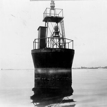
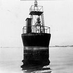 the 1919 caisson light (USCG)
.
In 1919, a simple skeleton tower on a small caisson was erected to replace the old light. The following year, the house was lifted from its foundation and barged north, where it was set on a new foundation to replace the Choptank River Light, which had been destroyed by ice in 1918. This light was eventually dismantled in 1964, but the caisson light at the original location remains in use.
References
- "Historic Light Station Information and Photography: Virginia". United States Coast Guard Historian's Office. http://www.uscg.mil/history/weblighthouses/LHVA.asp.
- Cherrystone Bar Light, from the Chesapeake Chapter of the United States Lighthouse Society
- de Gast, Robert (1973). The Lighthouses of the Chesapeake. Johns Hopkins University Press. p. 170.
 Categories:
- Lighthouses in Virginia
- Buildings and structures completed in 1858
- Buildings and structures in Northampton County, Virginia
- Transportation in Northampton County, Virginia
Wikimedia Foundation. 2010.