- Nansemond River Light
-
Nansemond River Light 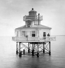
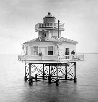
Undated photograph of Nansemond River Light (USCG) Location mouth of Nansemond River off Pig Point Coordinates 36°54′43″N 76°26′42″W / 36.912°N 76.445°WCoordinates: 36°54′43″N 76°26′42″W / 36.912°N 76.445°W
(approx.)Year first lit 1878 Deactivated 1935 Foundation screw-pile Construction cast-iron/wood Tower shape square house Height 36 ft Original lens sixth-order Fresnel lens (upgraded to fifth-order in 1899) The Nansemond River Light was a screwpile lighthouse located at the confluence of the Nansemond and James rivers in Virginia.
History
This light was erected in 1878 to mark the east side of the entrance to the Nansemond River. Some parts were recycled from the old Roanoke Marshes Light, which had been replaced the previous year. Little of note is recorded about this light, though in 1915 the keeper was cited for recovering a woman's wristwatch dropped overboard. The light was an early victim of automation in 1935, and in the late 1980s the whole structure was removed, leaving no trace of the light to be seen.
References
- "Historic Light Station Information and Photography: Virginia". United States Coast Guard Historian's Office. http://www.uscg.mil/history/weblighthouses/LHVA.asp.
- Nansemond River Light, from the Chesapeake Chapter of the United States Lighthouse Society
- de Gast, Robert (1973). The Lighthouses of the Chesapeake. Johns Hopkins University Press. p. 149.
- National Oceanic and Atmospheric Administration (1974). Hampton Roads (Map). 1:20,000. Chart no. 12245.
 Categories:
- Lighthouses in Virginia
- Buildings and structures completed in 1878
- James River (Virginia)
- Buildings and structures in Suffolk, Virginia
Wikimedia Foundation. 2010.