- Craney Island Light
-
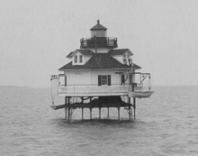
Craney Island Light Undated photograph of Craney Island Light (USCG) Location just east of Craney Island at the mouth of the Elizabeth River Coordinates 36°53′31″N 76°20′13″W / 36.892°N 76.337°WCoordinates: 36°53′31″N 76°20′13″W / 36.892°N 76.337°W
(approx.)Year first lit 1859 (first);
1884 (second)Deactivated 1936 Foundation screw-pile Construction cast-iron/wood Tower shape square house (first);
hexagonal house (second)Height 36 ft Original lens fifth-order Fresnel lens The Craney Island Light was a screwpile lighthouse located just east of Craney Island at the mouth of the Elizabeth River in Virginia. This light replaced the first permanently stationed lightship in the United States.
History
Craney Island forms the west side of the entrance to Norfolk's harbor and has been used as a military facility since the War of 1812. In 1820 a lightship was stationed off its eastern side to protect the edge of the channel. This ship had previously been stationed off Willoughby's Shoal, but was quickly moved after it was determined that the first location was too exposed. This was the first permanent lightship station in the country; it was replaced in 1859 by the first of two screw-pile lights, a square house which survived until 1884. In that year the decrepit structure was replaced with a new hexagonal house, which in turn was removed in 1936, to be replaced by an automated light on the old foundation. In the early 1970s the light was completely removed and replaced by a buoy.
References
- "Historic Light Station Information and Photography: Virginia". United States Coast Guard Historian's Office. http://www.uscg.mil/history/weblighthouses/LHVA.asp.
- Craney Island Light, from the Chesapeake Chapter of the United States Lighthouse Society
- de Gast, Robert (1973). The Lighthouses of the Chesapeake. Johns Hopkins University Press. p. 149.
- National Oceanic and Atmospheric Administration (2006). Norfolk Harbor and Elizabeth River (Map). 1:20,000. Chart no. 12253.
 Categories:
- Lighthouses in Virginia
- Buildings and structures completed in 1859
- Buildings and structures completed in 1884
Wikimedia Foundation. 2010.

