- Curzon Street railway station
-
Curzon Street 
Operations Original company London and Birmingham Railway Post-grouping London, Midland and Scottish Railway History 24 June 1838 Station opens as Birmingham November 1852 renamed Birmingham Curzon Street 1 July 1854 closed partly 22 May 1893 Final closure[1] Disused railway stations in the United Kingdom Closed railway stations in Britain
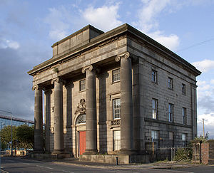
A B C D–F G H–J K–L M–O P–R S T–V W–ZCurzon Street railway station (formerly Birmingham station) was a railway station in Birmingham that was used briefly for regular scheduled passenger services between 1838 and 1854 when it acted as the terminus for both the London and Birmingham Railway and the Grand Junction Railway, with lines connecting Birmingham to London and to Manchester and Liverpool respectively. It was then used for excursions until 1893 and goods traffic until 1966 when it closed. More recently, the surviving Grade I listed, entrance building has been used for occasional art events.
In 2010, a new Curzon Street station, partly on the site of the historical station was proposed as the Birmingham terminus for High Speed 2.
Contents
History
The station was opened in 1838, with the first train from London to Birmingham arriving on 17 September. It was the terminus for both the London and Birmingham Railway and the Grand Junction Railway and the companies had adjacent, parallel platforms but did not offer through services. The railway station was inconveniently located on the eastern edge of Birmingham city centre and its use as a passenger station was short-lived following the merging of the two companies into the London and North Western Railway in 1846. A smaller goods station, Lawley Street Goods Station, was located[when?] to the east of the station.
On 27 January 1847, the Institution of Mechanical Engineers was established with George Stephenson as its first president in the nearby Queen's Hotel; a plaque commemorating the event is located inside the station building, as the hotel has since been demolished.
The new railway company completed New Street Station half a mile to the west of Curzon Street Station in 1854 which they shared with Midland Railway. Regular passenger services at Curzon Street ceased the same year and the name of the station had been changed from 'Birmingham' to 'Birmingham Curzon Street' in November 1852. Holiday excursions continued until 1893 and it was a goods station until 1966.
The surviving entrance building
The surviving Grade I listed entrance building was designed by Philip Hardwick, constructed in 1838 and is the world's oldest surviving piece of monumental railway architecture. The architecture is Roman inspired, following Hardwick's trip to Italy in 1818–19. It has tall pillars running up the front of the building, made out of a series of huge blocks of stone. The design mirrored the Euston Arch at the London end of the L&BR. As part of the original design, the building was to be flanked by two arches leading into the station, but excavations revealed that these were never built. The interior housed the booking hall, with a large iron balustraded stone staircase, a refreshment room and offices. It is three storeys tall but relatively small.
The building was used by a University of Birmingham student theatre group, the 'Three Bugs Fringe Theatre'.[citation needed] The building was also proposed as a new home for the Royal College of Organists however the proposal foundered in 2005 for lack of funds.[2] A Parcelforce depot to the rear of the station was demolished in May 2006.
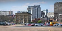
The building is unused currently except for the occasional art exhibition. The City Council had hoped to refurbish the building and find an alternative tenant . It was expected to be the centrepiece of the City Park and Masshouse development scheme, which is located around the site (most of the surrounding buildings having been demolished).[citation needed]
However, these plans have now been superseded by the High Speed 2 proposal. The new station would leave the surviving entrance building intact,[3] and could incorporate it.[n 1]
Proposed High Speed 2 terminus
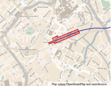
See also: High Speed 2A new station built partly on the site of the old Curzon Street station[3] is proposed as the Birmingham terminus for the High Speed 2 railway line. It is referred to as Birmingham Fazeley Street in the report produced by High Speed 2 Ltd[n 2] but, as Birmingham Curzon Street in the government's command paper, setting out official policy on high speed rail.[n 3]
The station would have six 415-metre (1,362 ft) terminal platforms.[3] Capacity would be needed for services to the north as well as to London.[n 4]
The new station would be adjacent to Birmingham Moor Street and the two stations could be directly linked.[n 5] A link to Birmingham New Street via a people mover with a journey time of two minutes is possible.[n 6]
A design sketch for the station has been submitted by Sir Terry Farrell, architect of Beijing South Railway Station.[n 7]
It is thought that the new station could make a significant contribution to the regeneration of the area, although the pre-existing plans would have to be revised, [n 8] including those of Birmingham City University for a new Eastside campus.[4] The Curzon Gate student residence (opened 2008) would have to be demolished.[n 9] Birmingham City University wanted a £30,000,000 refund after high speed rail's plans for the campus were declared.[5]
Notes
- ^ Department for Transport (2010a), page 115
- ^ High Speed 2(2010), page 117 (chapter 3)
- ^ Department for Transport (2010a), page 112-113
- ^ High Speed 2(2010), page 115 (chapter 3)
- ^ High Speed 2(2010), page 117 (chapter 3)
- ^ Department for Transport (2010a), page 113
- ^ Department for Transport (2010a), page 105
- ^ Department for Transport (2010a), page 115
- ^ High Speed 2(2010), page 118
References
- Documents referenced from 'Notes' section
- Department for Transport (2010a) (pdf). High Speed Rail - Command Paper. The Stationery Office. ISBN 9780101782722. http://webarchive.nationalarchives.gov.uk/+/http://www.dft.gov.uk/pgr/rail/pi/highspeedrail/commandpaper/pdf/cmdpaper.pdf. Retrieved 2010-03-13.
- High Speed 2 (2010). "High Speed Rail London to the West Midlands and Beyond: A Report to Government by High Speed Two Limited". http://www.dft.gov.uk/pgr/rail/pi/highspeedrail/hs2ltd/hs2report/.
- Other references for article
- ^ Butt, R.V.J., (1995) The Directory of Railway Stations, Yeovil: Patrick Stephens
- ^ Roz Tappenden (2005-11-15). "Future uncertain for Curzon Street Station as RCO pulls out". Culture24. http://www.culture24.org.uk/places+to+go/west+midlands/birmingham/art31838. Retrieved 2009-11-24.
- ^ a b c High Speed 2 Feasibility study, Water Orton Corridor: Fazely Street Station, Plan Profile Sheet 7 of 7
- ^ "Birmingham City University wants £30m refund after high speed rail hits campus plan". 16-03-2010. http://www.birminghampost.net/news/west-midlands-news/2010/03/16/birmingham-city-university-wants-30m-refund-after-high-speed-rail-hits-campus-plan-65233-26044757/. Retrieved 2010-03-17.
- ^ "Birmingham City University wants £30m refund after high speed rail hits campus plan". 16-03-2010. http://www.birminghampost.net/news/west-midlands-news/2010/03/16/birmingham-city-university-wants-30m-refund-after-high-speed-rail-hits-campus-plan-65233-26044757/. Retrieved 2010-03-17.
Further reading
- Cragg, Roger (1997 (2nd edn)). Civil Engineering Heritage: Wales and West Central England. London: Thomas Telford. pp. 193–4. ISBN 0-7277-2576-9.
- Foster, Richard (1990). Birmingham New Street – the story of a great station, including Curzon Street, 1: Background and beginnings: the years up to 1860. Didcot: Wild Swan Publications. ISBN 0-906867-78-9.
External links
- Birmingham.gov.uk
- Lookingatbuildings entry
- Photo and description
- Rail Around Birmingham: Curzon Street railway station
- Organists scrap plans for new HQ – BBC Music Magazine
- Details from listed building database (217433) . Images of England. English Heritage.
- Buildings at Risk Register: Curzon+Street
Railway stations in the West Midlands county Open stations Acocks Green • Adderley Park • Aston • Blake Street • Bordesley • Bournville • Butlers Lane • Chester Road • Duddeston • Erdington • Five Ways • Four Oaks • Gravelly Hill • Hall Green • Hamstead • Jewellery Quarter • Kings Norton • Lea Hall • Longbridge • Moor Street • New Street • Northfield • Perry Barr • Selly Oak • Small Heath • Snow Hill • Spring Road • Stechford • Sutton Coldfield • Tyseley • University • Witton • Wylde Green • Yardley WoodDisused Bromford Bridge • Camp Hill • Castle Bromwich • Central Goods • Church Road • Curzon Street • Granville Street • Hagley Road • Handsworth & Smethwick • Handsworth Wood • Hazelwell • Hockley • Icknield Port Road • Kings Heath • Lawley Street • Lifford • Longbridge (1915-1964) • Monument Lane • Moseley • Penns • Rotton Park Road • Rubery • Saltley • Soho & Winson Green • Soho Road • Somerset Road • Sutton Park • Sutton Coldfield Town • Winson GreenBaptist End • Blowers Green • Brettell Lane • Brierley Hill • Brockmoor Halt • Bromley Halt • Darby End • Dudley • Gornal Halt • Halesowen • Harborne • Harts Hill • Old Hill High Street • Pensnett Halt • Round Oak • Windmill EndAlbion • Great Bridge North • Great Bridge South • Newton Road • Oldbury • Princes End & Coseley • Rood End • Smethwick West • Soho • Spon Lane • Swan Village • Tipton Five Ways • Wednesbury Central • Wednesbury Town • West BromwichAldridge • Bentley • Brownhills • Brownhills Watling Street • Darlaston • Darlaston James Bridge • North Walsall • Pelsall • Pleck • Rushall • Short Heath • Streetly • Walsall Wood • Willenhall Bilston Street • Willenhall Stafford Street • Wood GreenHeritage Midland Metro (Line 1) Bilston Central • Birmingham Snow Hill • Black Lake • Bradley Lane • Dartmouth Street • Dudley Street, Guns Village • Handsworth, Booth Street • Jewellery Quarter • Kenrick Park • Lodge Road, West Bromwich Town Hall • Loxdale • Priestfield • Soho, Benson Road • St. Paul's • The Crescent (Bilston) • The Hawthorns • The Royal • Trinity Way • Wednesbury, Great Western Street • Wednesbury Parkway • West Bromwich Central • Winson Green, Outer Circle • Wolverhampton, St. George'sList of West Midlands railway stations • Transport in the West Midlands • Midland Metro • Centro Coordinates: 52°28′53.80″N 1°53′10.94″W / 52.481611°N 1.8863722°W
Categories:- Buildings on the Buildings at Risk Register
- Buildings and structures completed in 1838
- Art museums and galleries in Birmingham, West Midlands
- Buildings and structures in Birmingham, West Midlands
- Disused railway stations in Birmingham, West Midlands
- Grade I listed railway stations
- London & Birmingham Railway
- Grand Junction Railway
- Railway stations opened in 1838
- Grade I listed buildings in the West Midlands
Wikimedia Foundation. 2010.


