- Tikopia
-
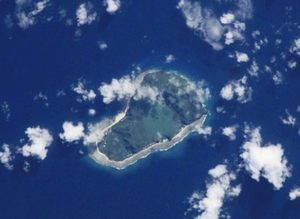
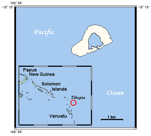
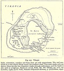
Tikopia is a small and high island in the southwestern Pacific Ocean. Covering an area of 5 km² (2 sq. mi.), the island is the remnant of an extinct volcano. Its highest point, Mt. Reani, reaches an elevation of 380 m (1,247 ft) above sea level. Lake Te Roto covers an old volcanic crater which is 80 m deep.
Tikopia's location is relatively remote. It is sometimes grouped with the Santa Cruz Islands. Administratively, Tikopia belongs to Temotu Province as the southernmost of the Solomon Islands.
Contents
Population
The population of Tikopia is about 1,200, distributed among more than 20 villages mostly along the coast. The largest village is Matautu on the west coast, not to be confused with Mata-Utu, the capital of Wallis and Futuna. Historically, the tiny island has supported a high-density population of a thousand or so. Strict reproductive policy prevented further increase. Unlike most of the Solomon Islands, the inhabitants are Polynesians, their language, Tikopian, is a member of the Samoic branch of the Polynesian languages and is generally referred to as a Polynesian outlier.
Tikopians practice an intensive system of agriculture (which has been compared to permaculture), similar in principle to forest gardening and the gardens of the New Guinea highlands. Their agricultural practices are strongly and consciously tied to the population density. For example, around 1600 AD, the people agreed to slaughter all pigs on the island, and substitute fishing, because the pigs were taking too much food that could be eaten by people.
Unlike the rapidly Westernizing society of much of the rest of Temotu province, Tikopia society is little changed from ancient times. Its people take great pride in their customs, and see themselves as holding fast to their Polynesian traditions while they regard the Melanesians around them to have lost most of theirs.
Four chiefs reign over the islands of Tikopia and Anuta, still holding court in their huts.
Tikopians have a highly developed culture with a strong Polynesian influence, including a complex social structure.
New Zealand anthropologist, Raymond Firth, who lived on Tikopia in 1928 and 1929, detailed the social life of Tikopia at that time. He showed how the society was divided geographically into two zones and was organized into four clans, headed by clan chiefs. At the core of social life was the te paito - the house inherited from male (patrilineal) ancestors, who were buried inside it. Relationships with the family grouping of one's mother (matrilateral relations) were also very important. The relations between a mother's brother and his nephew had a sacred dimension: the uncle oversaw the passage of his nephew through life, in particular, officiating at his manhood ceremonies. Intricate economic and ritual links between paito houses and deference to the chiefs within the clan organization were key dimensions of island life.
Raymond Firth speculates about the ways population control may have been achieved, including celibacy, warfare (including expulsion), infanticide and sea-voyaging (which claimed many youths). Currently, many young men leave the island, heading to either the Russell Islands or the national capital, Honiara, in search of work. As a result of this outflow, population control is less necessary.
Cyclone Zoe in December 2002 devastated the vegetation and human settlements in Tikopia. Despite the extensive damage, no deaths were reported, as the islanders followed their traditions and sheltered in the caves in the higher ground. The narrow bank that separated the freshwater lagoon from the sea was breached by the storm, resulting the continuing contamination of the lagoon and the threatened death of the sago palms on which the islanders depend for survival. A remarkable international effort by "friends of" the island, including many yacht crews who had had contact with Tikopia over the decades, culminated in the construction of a gabion dam to seal the breach.
Some discussions of Tikopian society include its nearest neighbour, the even tinier island of Anuta.
The Melanesian Mission (Anglican) first made contact with Tikopia in 1858. A mission teacher was not allowed to settle on Tikopia until 1907.[1]
See also
- Melanesia
- Oceania
- Pacific Islands
- Polynesian outlier
- Jared Diamond's book Collapse describes Tikopia as a success case in matching the challenges of sustainability, contrasting it with Easter Island.
References
- ^ Ethnographic Artifacts: Challenges to a Reflexive Anthropology, by S. R. Jaarsma, Marta Rohatynskyj , 2000, p. 112-13
External links
- An essay on Tikopia, prepared for the BBC
- BBC photo essay, from the aftermath of Cyclone Zoe Despite the overwhelming devastation and the greatest fears, no one on Tikopia was killed in the disaster.
- Tools and practical help after the cyclone
- Restoring the freshwater lagoon of Tikopia
- Solomon Islands - John Seach a Tour Site but with information on each of the islands
- older detail map
Further reading
- We the Tikopia (1936), Raymond Firth's classic study, still used in anthropology classes today
- Kirch, Patrick Viinton, Tikopia; The History and Ecology of a Polynesian Outlier, Bishop Museum Press, Honolulu, 1982.
- Firth, Raymond, The Work of the Gods in Tikopia, Melbourne: Melbourne University Press (1940, 1967)
- Firth, Raymond, SOCIAL CHANGE IN TIKOPIA. Re-Study of a Polynesian Community after a Generation, London: Allen and Unwin. 1959, 360 pages
Central Choiseul Guadalcanal Isabel Makira-Ulawa Malaita Adagege · Alite · Anuta Paina · Funaafou · Langa Langa Lagoon · Lau Lagoon · Laulasi · Maana'omba · Malaita · Maramasike · Mbasakana · Ndai · Ontong Java · Roncador Reef · Sikaiana · SulufouRennell and Bellona Temotu Anuta · Banie · Duff Islands · Fatutaka · Fenualoa · Lomlom · Makalom · Malo · Matema · Nendö · Nifiloli · Nukapu · Nupani · Patteson Shoal · Pigeon · Pileni · Reef Islands · Santa Cruz Islands · Taumako · Teanu · Tikopia · Tinakula · Utupua · VanikoroWestern Arundel · Faisi · Fauro · Ghizo · Ghoi · Kavachi · Kennedy · Kiambe · Kingguru · Kohinggo · Kolombangara · Liapari · Logha · Lola · Lumbari · Marovo · Matikuri · Mbava · Mborokua · Mbulo · Mondomondo · Mono · Nakaza · New Georgia · New Georgia Islands · Nggatokae · Nusatupe · Ranongga · Rendova · Shortland · Shortland Islands · Simbo · Stirling · Telina · Tetepare · Treasury Islands · Vella Lavella · Uepi · Vangunu · VonavonaPolynesia Polynesian triangle Polynesian outliers Anuta · Emae · Futuna · Kapingamarangi · Loyalty Islands · Mele · Nuguria · Nukumanu · Nukuoro · Ontong Java · Ouvéa · Pileni · Rennell · Sikaiana · Takuu · TikopiaPolynesian-influenced Coordinates: 12°17′47.3″S 168°49′55.0″E / 12.296472°S 168.83194°E
Categories:- Islands of the Solomon Islands
- Polynesian outliers
Wikimedia Foundation. 2010.


