- Makira
-
Makira 
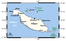
Makira and nearby islands
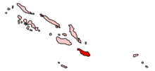
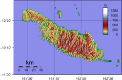
Location of Makira in Solomon IslandsGeography Location Solomon Islands Coordinates 10°33′04″S 161°49′41″E / 10.55111°S 161.82806°ECoordinates: 10°33′04″S 161°49′41″E / 10.55111°S 161.82806°E Area 3,190 km2 (1,232 sq mi) Country Solomon IslandsProvince Makira-Ulawa Province Largest city Kirakira The island of Makira (formerly San Cristobal) is the largest island of Makira-Ulawa Province in the Solomon Islands. The island is located east of Guadalcanal and south of Malaita. The largest and capital city is Kirakira.
Central Choiseul Guadalcanal Isabel Makira-Ulawa Malaita Adagege · Alite · Anuta Paina · Funaafou · Langa Langa Lagoon · Lau Lagoon · Laulasi · Maana'omba · Malaita · Maramasike · Mbasakana · Ndai · Ontong Java · Roncador Reef · Sikaiana · SulufouRennell and Bellona Temotu Anuta · Banie · Duff Islands · Fatutaka · Fenualoa · Lomlom · Makalom · Malo · Matema · Nendö · Nifiloli · Nukapu · Nupani · Patteson Shoal · Pigeon · Pileni · Reef Islands · Santa Cruz Islands · Taumako · Teanu · Tikopia · Tinakula · Utupua · VanikoroWestern Arundel · Faisi · Fauro · Ghizo · Ghoi · Kavachi · Kennedy · Kiambe · Kingguru · Kohinggo · Kolombangara · Liapari · Logha · Lola · Lumbari · Marovo · Matikuri · Mbava · Mborokua · Mbulo · Mondomondo · Mono · Nakaza · New Georgia · New Georgia Islands · Nggatokae · Nusatupe · Ranongga · Rendova · Shortland · Shortland Islands · Simbo · Stirling · Telina · Tetepare · Treasury Islands · Vella Lavella · Uepi · Vangunu · VonavonaCategories:- Islands of the Solomon Islands
- Solomon Islands geography stubs
Wikimedia Foundation. 2010.


