- New Georgia
-
New Georgia 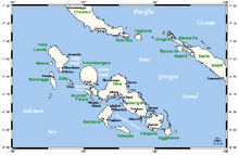
New Georgia Islands with main centres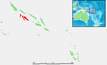
Geography Location Pacific Ocean Coordinates 8°15′S 157°30′E / 8.25°S 157.5°E Archipelago Solomon Islands Area 2,037 km2 (786.5 sq mi) Length 72 km (44.7 mi) Country Solomon Islandsprovince Western Province 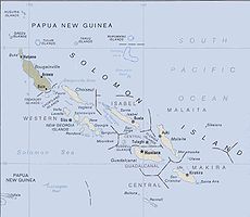 Solomon Islands
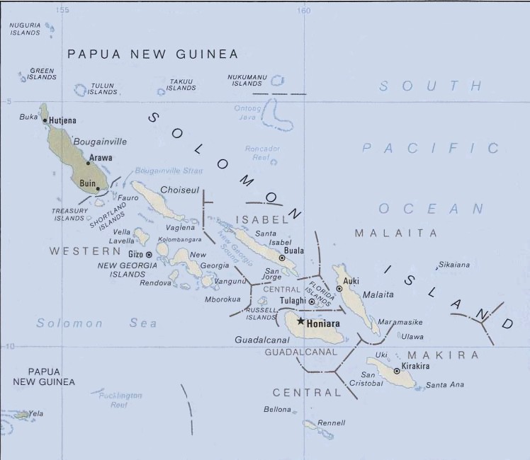
New Georgia is the largest island of the Western Province of the Solomon Islands.
Contents
Geography
This island is located in the New Georgia Group, an archipelago including most of the other larger islands in the province. About 72;km (45 miles) long, it forms part of the southern boundary of the New Georgia Sound; Kolombangara lies across the Kula Gulf to the west, Vangunu is to the east, and Rendova to the south, across the Blanche Channel.
The island is rugged and heavily forested.
History
Central part of New Georgia is cradle of Roviana culture. The large complex of Bao megalithic shrines and other structures was developed in 13th century AD.[1] Later, in 15th - 17th centuries Roviana people moved over to smaller barrier islands at New Georgia with a hub in Nusa Roviana[2]. Through trade and heat hunting expeditions Nusa Roviana turned into regional centre of power and trade. In late 19th century the rule of the last chief of head hunters Ingova was overpowered by British colonial army.
The Methodist Mission in New Georgia was established by Rev. John Frances Goldie in 1902. He dominated the mission and gained the loyalty of Solomon Islander members of his church.[3] The relationship with the colonial administrators of the British Solomon lsland Protectorate were also fraught with difficulty, at this time due to Goldie’s effective control over the Western Solomon Islands.[3] From 1927 to 1934 Dr Edward Sayers worked at the Methodist mission where he established a hospital at Munda and carried out fieldwork in the treatment of malaria.[4]
During World War II, the United States' New Georgia Campaign opened with landings on New Georgia and nearby islands on 30 June 1943. New Georgia was secured by American forces on 23 August, after weeks of difficult and bloody jungle fighting, although fighting continued on some nearby islands until October 1943. Rodger Wilton Young, an Army soldier who was originally a Sergeant, and had requested a demotion to the rank of Private due to his deteriorating sight and hearing, destroyed a machine gun nest in combat on New Georgia, allowing his comrades to reach safety. For this action in combat, he was awarded the Congressional Medal of Honor.
Also, several significant naval battles between warships of the U.S. Navy and its allies, and the Imperial Japanese Navy occurred in the waters near New Georgia Island, such as the Battle of Kula Gulf, in 1943
Munda, the Japanese base on New Georgia Island, was the main objective of the assault on the island. This base was not overrun until 5 August 1943. The Japanese port at Bairoko Harbor, 13 km (eight miles) north of Munda, were not taken until 25 August.
Languages
The ten languages spoken on the island are from the family of New Georgia languages, a subgroup of the Northwest Solomonic languages within the Oceanic languages, a major group of the Austronesian family.
Further reading
References
- ^ Peter J. Shepherd, Richard Walter, Takuya Nagaoka. "The Archaeology of Head-Hunting in Roviana Lagoon, New Georgia". The Journal of Polynesian Society. http://www.jps.auckland.ac.nz/document//Volume_109_2000/Volume_109,_No._1/The_archaeology_of_head-hunting_in_Roviana_Lagoon,_New_Georgia,_by_Peter_J._Sheppard,_Richard_Walter_and_Takuya_Nagaoka,_p_9-38/p1.
- ^ "Nusa Roviana hillfort and shrine". Wondermondo. http://www.wondermondo.com/Countries/Au/Solomon/Western/NusaRoviana.htm.
- ^ a b Dr. Debra McDougall (2008). "Religious institutions as Alternative Structures in post-conflict Solomon Islands: Cases from Western Province". For State, Society and Governance in Melanesia Discussion Paper Series, 08/05, Australian National University. http://westernsolomons.uib.no/people/mcdougall.php. Retrieved 4 Oct. 2011.
- ^ Sayers , E. G. (1943) Malaria in the South Pacific with Special Reference to the Solomon Islands. New Zealand Government Printing Office
Coordinates: 8°15′S 157°30′E / 8.25°S 157.5°E
Central Choiseul Guadalcanal Isabel Makira-Ulawa Malaita Adagege · Alite · Anuta Paina · Funaafou · Langa Langa Lagoon · Lau Lagoon · Laulasi · Maana'omba · Malaita · Maramasike · Mbasakana · Ndai · Ontong Java · Roncador Reef · Sikaiana · SulufouRennell and Bellona Temotu Anuta · Banie · Duff Islands · Fatutaka · Fenualoa · Lomlom · Makalom · Malo · Matema · Nendö · Nifiloli · Nukapu · Nupani · Patteson Shoal · Pigeon · Pileni · Reef Islands · Santa Cruz Islands · Taumako · Teanu · Tikopia · Tinakula · Utupua · VanikoroWestern Arundel · Faisi · Fauro · Ghizo · Ghoi · Kavachi · Kennedy · Kiambe · Kingguru · Kohinggo · Kolombangara · Liapari · Logha · Lola · Lumbari · Marovo · Matikuri · Mbava · Mborokua · Mbulo · Mondomondo · Mono · Nakaza · New Georgia · New Georgia Islands · Nggatokae · Nusatupe · Ranongga · Rendova · Shortland · Shortland Islands · Simbo · Stirling · Telina · Tetepare · Treasury Islands · Vella Lavella · Uepi · Vangunu · VonavonaCategories:


Wikimedia Foundation. 2010.