- South Malaita Island
-
 Maramasike and neighbouring areas
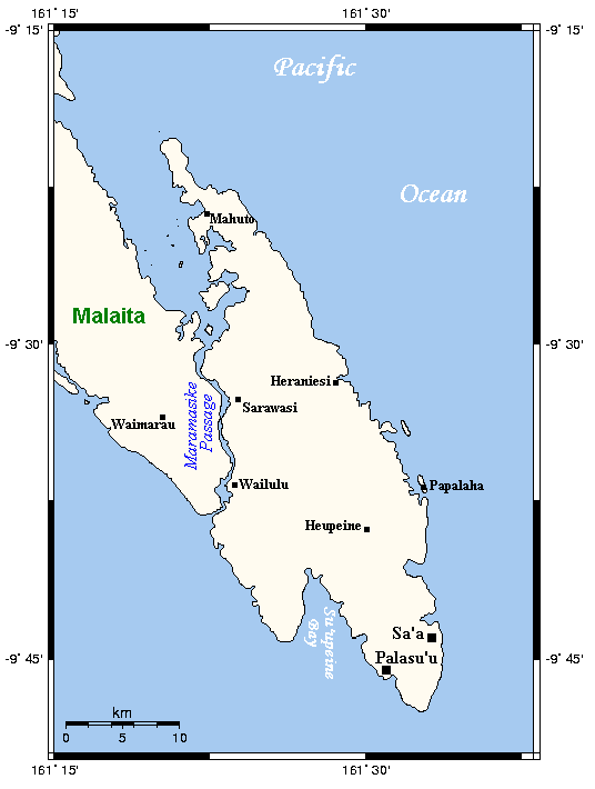
South Malaita Island, also known as Small Malaita and Maramasike, is a large island at the southern tip of the larger island of Malaita in the eastern part of the Solomon Islands. It is called "small" to distinguish it from the much larger mainland. It is now part of Malaita Province. During the colonial days, the island was divided by the colonial government and missionary establishments into the Asimeuri, Asimae, and Raroisu'u districts. Away from Malaita, most people from "Small" or "South" Malaita usually just say the word "South", everyone knows what they mean.
People on the island, however, preferred to identify only with members of their extended families, where ties are the strongest, and with members of their clans and tribes, which are governed within traditionally demarcated regions known as iolas. The language spoken by the people of Small Malaita is the Sa'a dialect. The language, however, has variations in pronunciation, grammar and vocabulary from iola to iola. The people practised patrilineal descent, with men having the most say over ownership rights and recognised as head of families, clans and tribes. Women played a much lesser role in the art of governing; however, they were equally respected in society.
Coordinates: 9°32′46″S 161°28′01″E / 9.546°S 161.467°E
Central Choiseul Guadalcanal Isabel Makira-Ulawa Malaita Adagege · Alite · Anuta Paina · Funaafou · Langa Langa Lagoon · Lau Lagoon · Laulasi · Maana'omba · Malaita · Maramasike · Mbasakana · Ndai · Ontong Java · Roncador Reef · Sikaiana · SulufouRennell and Bellona Temotu Anuta · Banie · Duff Islands · Fatutaka · Fenualoa · Lomlom · Makalom · Malo · Matema · Nendö · Nifiloli · Nukapu · Nupani · Patteson Shoal · Pigeon · Pileni · Reef Islands · Santa Cruz Islands · Taumako · Teanu · Tikopia · Tinakula · Utupua · VanikoroWestern Arundel · Faisi · Fauro · Ghizo · Ghoi · Kavachi · Kennedy · Kiambe · Kingguru · Kohinggo · Kolombangara · Liapari · Logha · Lola · Lumbari · Marovo · Matikuri · Mbava · Mborokua · Mbulo · Mondomondo · Mono · Nakaza · New Georgia · New Georgia Islands · Nggatokae · Nusatupe · Ranongga · Rendova · Shortland · Shortland Islands · Simbo · Stirling · Telina · Tetepare · Treasury Islands · Vella Lavella · Uepi · Vangunu · VonavonaCategories:- Islands of the Solomon Islands
- Solomon Islands geography stubs
Wikimedia Foundation. 2010.