- Nukumanu Islands
-
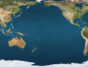
 NukumanuLocation of Nukumanu Atoll in the Pacific Ocean
Nukumanu 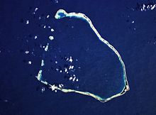
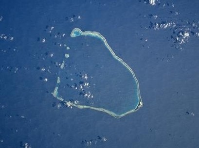
NASA picture of Nukumanu AtollGeography Location Pacific Ocean Coordinates 4°31′S 159°24′W / 4.517°S 159.4°W Archipelago Scattered group of seven atolls Total islands 22 Area 4.6 km2 (1.78 sq mi) Highest elevation 2 m (7 ft) Country Demographics Population 730 (as of 2000[1]) Nukumanu, formerly Tasman Islands, is a medium sized atoll located in the Southwestern Pacific Ocean, 4 degrees south of the equator.
Contents
Description
Administratively Nukumanu is part of Papua New Guinea, but it lies quite far away from the closest territory of Papua New Guinea proper, which is the coast of New Ireland at 682 km to the west. The nearest land is Ontong Java Atoll, located only 38 km to the south of Nukumanu, but the border between Papua New Guinea and the Solomon Islands runs between these neighboring atolls.
Comprising a ring of more than twenty islets on a reef surrounding a large lagoon, Nukumanu's sandy islands are located on a strip of coral rising no more than a meter above sea level. The main inhabited islands of Nukumanu are located on the eastern end of the atoll.
History
In Polynesian history, the main cultural and commercial exchanges took place with the inhabitants of neighboring Ontong Java Atoll, with whom Nukumanu people share many cultural affinities.[2]
Towards the end of the 19th century Nukumanu became part of the German colonial empire. It was transferred to Australian administration in 1914, after Germany's defeat in World War I.[3]
Nukumanu's most recent claim to fame, is that it was the last place on the path of Amelia Earhart before she and her co-pilot disappeared forever into the vast Pacific Ocean.
The land resources of the Nukumanu people are quite few and they grow a kind of taro and bananas. Coconuts are an integral part of the islanders' diet with the soft inside being a staple food and coconut flesh being consumed with raw fish and clams. They are also competent fishermen who dive for bêche-de-mer in the lagoon. This is exported mainly to Asia and along with trochus shells which are used to make mother-of-pearl, they comprise the backbone of the Nukumanu economy.
Anthropological studies
This atoll has a Polynesian population whose ancestors migrated westwards out of Polynesia. Their language is classified in the Samoic Outlier branch of Polynesian.[4] The Nukumanu Islands, together with neighboring Ontong Java retain a Polynesian character despite their location in the Melanesian Archipelago of Papua New Guinea and the Solomon Islands respectively.
The first serious research on Nukumanu's inhabitants was conducted by German ethnographers Ernst Sarfert and Hans Damm, during a German scientific expedition of the Southern Seas that took place in 1908-1910. This expedition visited both Nukumanu and neighboring Ontong Java Atoll, where they also carried out their research. Their work, "Luangiua und Nukumanu" was published in 1931.
References
- ^ David Stanley, South Pacific handbook
- ^ Sarfert, Ernst, and Hans Damm. "Luangiua und Nukumanu." Ergebnisse der Südsee Expedition, 1908-1910. Hamburg 1931. Vol I
- ^ Hermann Joseph Hiery: Die deutsche Verwaltung Neuguineas 1884-1914, in: Ders. (Hrsg.), Die deutsche Südsee 1884-1914, Paderborn u.a. 22001, S. 279ff.
- ^ [Polynesian languages Ethnologue - Nukumanu Language]
Bibliography
- Sarfert, Ernst, and Hans Damm. Luangiua und Nukumanu. Ergebnisse der Südsee Expedition, 1908-1910. Hamburg 1931, 2 vols.
External links
Coordinates: 4°31′30″S 159°24′00″E / 4.525°S 159.4°E
Polynesia Polynesian triangle Polynesian outliers Anuta · Emae · Futuna · Kapingamarangi · Loyalty Islands · Mele · Nuguria · Nukumanu · Nukuoro · Ontong Java · Ouvéa · Pileni · Rennell · Sikaiana · Takuu · TikopiaPolynesian-influenced Categories:- Islands of Papua New Guinea
- Polynesian outliers

Wikimedia Foundation. 2010.