- Manus Island
-
Manus 
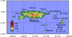
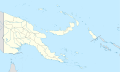
Admiralty IslandsGeography Coordinates 02°05′00″S 147°00′00″E / 2.0833333°S 147°E Archipelago Admiralty Islands Area 2,100 km2 (810 sq mi) Length 100 km (60 mi) Width 30 km (19 mi) Highest elevation 718 m (2,356 ft) Highest point Mt. Dremsel Country Papua New GuineaProvince Manus Province Largest city Lorengau (pop. 5,829) Demographics Population 33,000 Density 15.71 /km2 (40.69 /sq mi) Manus Island is part of Manus Province in northern Papua New Guinea and is the largest island of the Admiralty Islands. It is the fifth largest island in Papua New Guinea with an area of 2,100 km², measuring around 100 km × 30 km. According to the 2000 census, Manus Island had a population of approximately 43,000. Lorengau, the capital of Manus Province, is located on the island. Momote Airport, the terminal for Manus Province, is located on nearby Los Negros Island. A bridge connects Los Negros to Manus Island and the province capital of Lorengau.
Manus Island is covered in rugged jungles, which can be broadly described as lowland tropical rain forest. The highest point on Manus Island is Mt. Dremsel 718 metres (2,356 feet) above sea level at the centre of the south coast. Manus is volcanic in origin and probably broke through the ocean's surface in the late Miocene, 8–10 million years ago. The substrate of the island is either directly volcanic or from uplifted coral limestone.
Manus Island is home to the Emerald green snail, whose shells are harvested to be sold as jewellery.
Contents
History
In World War II Manus was the site of an observation post manned by No. 4 Section, 'B' Platoon, 1st Independent Company, Australian Imperial Force.[1], who also provided medical treatment to the inhabitants.[2] Manus was first bombed by the Japanese on 25 January 1942, the radio mast being the main target.[1] On 8 April 1942 an Imperial Japanese force consisting of the light cruiser Tatsuta, destroyer Mutsuki and a troop transport ship Mishima Maru entered Lorengau harbour, and several hundreds of Japanese soldiers of the 8th Special Base Force, swarmed ashore onto Australia's mandated responsibility. With little and limited resources the Australian 4th section withdrew to the jungle.[1]
Later in 1942, Japan established a military base on Manus. This was attacked by United States forces in the Admiralty Islands campaign of February–March 1944. An Allied naval base was established at Seeadler Harbor on the island and it later supported the British Pacific Fleet.
In 1950–51 the Australian government conducted the last trials against Japanese war criminals on the island.[3]
One case heard was that of Takuma Nishimura, who faced an Australian military court. He had already been tried by a British military court in relation to the Sook Ching massacre in Singapore and sentenced to life imprisonment. While on a stopover in Hong Kong he was intercepted by Australian Military Police personnel. Evidence was presented stating that Nishimura had ordered the shootings of wounded Australian and Indian soldiers at Parit Sulong and the disposal of bodies so that there was no trace of evidence. In this trial he was found guilty and was hanged on 11 June 1951.
American anthropologist Margaret Mead lived on Manus before and after the war, of which she gives a detailed account in the book Growing up in New Guinea and New Lives for Old.
A detention centre was built on Manus Island in 2001 as part of Australia's Pacific Solution. The last inmate was Aladdin Sisalem, who was kept as a lone inmate from July 2003, until he was finally granted asylum in Australia in June 2004.
See also
Notes
- ^ a b c L, Klemen (1999-2000). "Manus Island, experience of No. 4 Section, 'B' Platoon, First Independent Company, Australian Imperial Force". Forgotten Campaign: The Dutch East Indies Campaign 1941-1942. http://www.dutcheastindies.webs.com/manus.html.
- ^ L, Klemen (1999-2000). "Medical Patrol on Manus Island, 1941". Forgotten Campaign: The Dutch East Indies Campaign 1941-1942. http://www.dutcheastindies.webs.com/medical.html.
- ^ Piccigallo, Philip; The Japanese on Trial; Austin 1979; ISBN 0-292-78033-8, ch.: "Australia".
External links
Coordinates: 02°05′00″S 147°00′00″E / 2.0833333°S 147°E
Categories:- Islands of Papua New Guinea
- Volcanoes of Papua New Guinea
- Miocene volcanoes
- Manus Province
Wikimedia Foundation. 2010.

