- Goodenough Island
Infobox Islands
name = Goodenough Island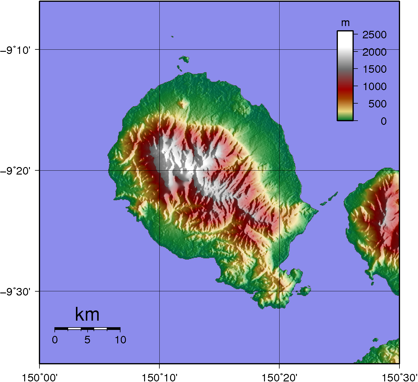
image caption =
locator
Location map|Papua New Guinea|lat=-9.366667|long=150.266667
map_custom = yes
native name =
native name link =
location =Melanesia
coordinates= coord|9|22|S|150|16|E|type:isle
archipelago =D'Entrecasteaux Islands
total islands =
major islands =
area = convert|687|km2|sqmi
highest mount = Mount Vineuo
elevation = convert|2536|m|ft
country = Papua New Guinea
country admin divisions title =
country admin divisions =
country largest city =
country largest city population =
population =
population as of =
density =
ethnic groups =Goodenough Island is in the
Milne Bay Province ofPapua New Guinea . It lies to the east of the mainland, in theSolomon Sea . [http://islands.unep.ch/IHD.htm#850] It is one of theD'Entrecasteaux Islands , is near theTrobriand Islands and should not be confused with Goodenough's Island.History
The island was visited in
1873 by CaptainJohn Moresby , commanding "HMS Basilisk", who named it after CommodoreJames Graham Goodenough .The island is roughly circular in shape, measuring 39 km by 26 km with an area of 687 km² and a shoreline of 116 km. From a coastal belt varying in width from 2 km to 10 km wide the island rises sharply to the volcanic summit of Mount Vineuo, 2,536 m high, making it one of the most precipitous islands in the world. [http://www.oceandots.com/pacific/png/goodenough.htm] (The most precipitous is
Heard Island rising from a base of 378 km² to a height of 2,745 m.) [http://www.worldislandinfo.com/MISINFORMATION.htm]World War II
A convoy of troops of 350 marines of 5th Sasebo Special Naval Landing Force, bound for
Taupota and participation in theBattle of Milne Bay , led by Commander Tsukioka, was stranded on Goodenough Island on25 August 1942 , while resting on the island their barges were destroyed byNo. 75 Squadron RAAF P-40 's.The HMAS Stuart and HMAS Arunta disembarked 640 soldiers of Drake Force consisting of the
Australian 2/12 Battalion , of the18th Brigade fromMilne Bay on Goodenough Island on22 October 1942. They landed from on both sides of the island's southern tip during the night. Intense fighting occurred during the23 October and during the night of 23 October, about 250 Japanese were evacuated by submarine toFergusson Island , where they were taken by cruiser toRabaul . The remaining Japanese defenders were mopped up and island declared secured by the 27 October.Due to the strategic importance of the island for the forthcoming operations against the
Imperial Japanese forces in theSouth West Pacific Area , the small Australian occupation force, used deception andcamouflage to make the Japanese believe that a brigade sized force was occupying the island. They fabricated dummy objects including a hospital, anti-aircraft guns constructed of simple logs pointed at the sky, barricades of jungle vines which looked like barbed wire, lighting fires to appear as cooking fires for large numbers of soldiers, and sending messages consistent with what a brigade of soldiers would be expected to send. The force was able to keep the Japanese at bay until reinforcements arrived.The mission airstrip on the island at
Vivigani , was developed intoVivigani Airfield , an airfield for Australian and American aircraft and troops as a staging point for operations inNew Guinea .Villages
List of villages working clockwise around Goodenough Island starting at Vivigani airstrip on the northeast coastal plain, as shown in Google Earth.
* Vivigani (near the air strip)
* Bolubolu (the administrative centre)
* Wailagi
* Kilia
* Lauwela
* Auwale
* Debenefue
* Diodio
* Tatala
* Waibula
* Wataluma Mission and Plantation
* Ulaluya MissionThe total population is 12,676 (1980 prelim.)Protected Area
The Oi Mada Wara Wildlife Management Area in the centre of the island is 22,840 ha. It provides a critical landscape function with a relatively high number of endemic, endangered and vulnerable species. The small black dorcopsis wallaby (Dorcopsis atrata), the only wallaby known to be endemic to a Pacific island, is endangered and needs careful management.IUCN2006 | assessors = Australasian Marsupial & Monotreme Specialist Group | year = 1996 | id = 6794 | title = Dorcopsis atrata | downloaded =
2007-09-12 ] Another species, theAgile Wallaby (Macropus agilis) was abundant but can not be found today. [http://www.conservation.org/xp/frontlines/species/10110501.xml]References
* [http://islands.unep.ch/IHD.htm#850 UN system-wide Earthwatch Web Site]
*Jenness M.A. and Rev. A. Ballantyne. (1920) "The Northern D'Entrecasteaux", Oxford University Press.
* [http://www.pacificwrecks.com/provinces/png_goodenough.html Pacific Wrecks website]
* [http://www.usyd.edu.au/news/84.html?newsstoryid=538 University of New South Wales News]
Wikimedia Foundation. 2010.