- New Britain
-
This article is about the island of New Britain in Papua New Guinea. For other uses of the name, see New Britain (disambiguation).
New Britain 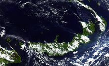
New Britain from space, June 2005. Clearly visible are ash plumes from Langila and Ulawun volcanoes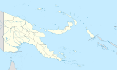
 New Britain (Papua New Guinea)
Geography Coordinates 5°44′S 150°44′E / 5.733°S 150.733°E Archipelago Bismarck Archipelago Area 36,520 km2 (14,100 sq mi)[1] Area rank 38th Length 520 km (323 mi) Width 29-146 km (-72.7 mi) Highest elevation 2,438 m (7,999 ft) Highest point Mount Sinewit Country Papua New GuineaDemographics Population 493,585 (as of 2010) Density 13.52 /km2 (35.02 /sq mi) Ethnic groups Papuans and Austronesians New Britain, or Niu Briten, is the largest island in the Bismarck Archipelago (named after Otto von Bismarck) of Papua New Guinea. It is separated from the island of New Guinea by the Dampier and Vitiaz Straits and from New Ireland by St. George's Channel. The main towns of New Britain are Rabaul/Kokopo and Kimbe.
While the island was part of German New Guinea, it was named Neupommern ("New Pomerania").
Contents
Geography
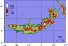 Topography of New Britain
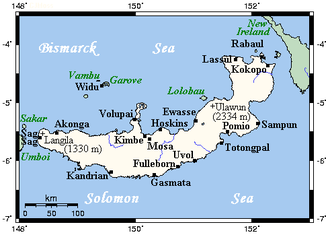 New Britain, with selected towns and volcanoes
New Britain extends from 148°18'31" to 152°23'57" E. longitude and from 4°08'25" to 6°18'31" S. latitude. It is crescent-shaped, approximately 520 km (320 mi) along its southeastern coastline, and from 29 to 146 km (18–91 miles) wide, not including a small central peninsula. The air-line distance from west to east is 477 km (296 mi). The island is the 38th largest in the world, with an area of 36,520 km2 (14,100 sq mi).
Steep cliffs form some sections of the coastline; in others the mountains are further inland, and the coastal area is flat and bordered by coral reefs. The highest point, at 2,438 m (7,999 ft), is Mount Sinewit in the Baining range in the east. Most of the terrain is covered with tropical rainforest and several large rivers are fed by the high rainfall.
New Britain was largely formed by volcanic processes, and there are several active volcanoes on the island, including Ulawun (the highest volcano in Papua New Guinea), Langila, the Garbuna Group, the Sulu Range, and the volcanoes Tavurvur and Vulcan of the Rabaul caldera. A major eruption of Tavurvur in 1994 destroyed the East New Britain provincial capital of Rabaul. Most of the town still lies under metres of ash, and the capital has been moved to nearby Kokopo.
Administrative divisions
New Britain forms part of the Islands Region, one of four regions of Papua New Guinea. It comprises the mainland of two provinces:
- East New Britain with headquarters in Kokopo (formerly Rabaul)
- West New Britain with headquarters in Kimbe
History
1700-1914
William Dampier became the first known European to visit New Britain on February 27, 1700: he dubbed the island with the Latin name Nova Britannia.
In November 1884, Germany proclaimed its protectorate over the New Britain Archipelago; the German colonial administration gave New Britain and New Ireland the names of Neupommern (or Neu-Pommern; "New Pomerania") and Neumecklenburg (or Neu-Mecklenburg; "New Mecklenburg") respectively, and the whole island group was renamed the Bismarck Archipelago. New Britain became part of German New Guinea.
In 1909, the indigenous population was estimated at about 190,000; the foreign population at 773 (474 white). The expatriate population was practically confined to the northeastern Gazelle Peninsula, which included the capital, Herbertshöhe (now Kokopo). At the time 5,448 hectares (13,464 acres) had been converted to plantations, primarily growing copra, cotton, coffee and rubber. Westerners avoided exploring the interior initially, believing that the indigenous peoples were warlike and would fiercely resist intrusions.
On 11 September 1914, New Britain became the site of one of the earliest battles of World War I when the Australian Naval and Military Expeditionary Force landed on the island. They quickly overwhelmed the German forces and occupied the island for the duration of the war. In 1920 the League of Nations included New Britain along with the former German colony on New Guinea in the Territory of New Guinea, a mandated territory of Australia.
World War II
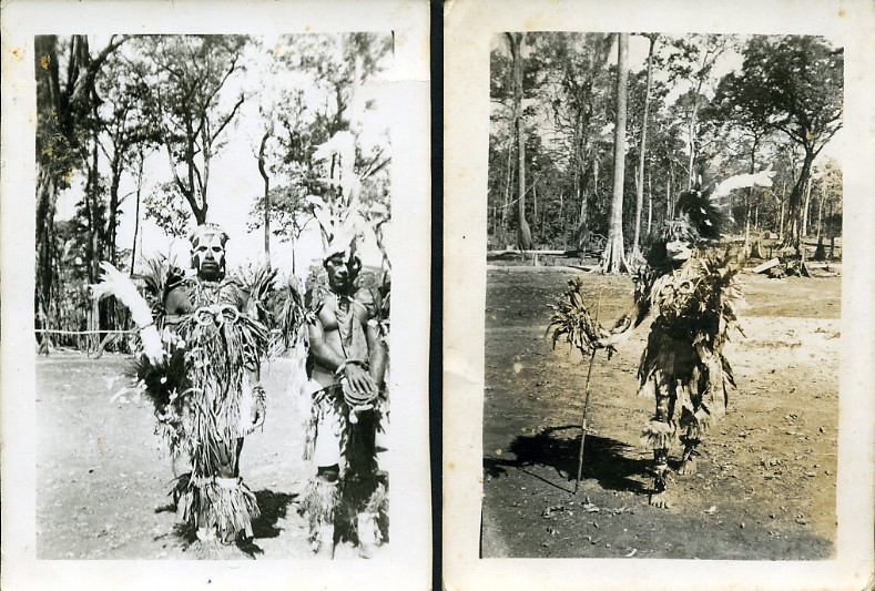
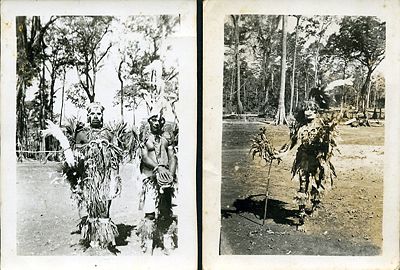 Two photographs of native New British Islanders, 1944
During World War II the Japanese attacked New Britain soon after the outbreak of hostilities in the Pacific Ocean. During January 1942, Japanese heavily bombed Rabaul. On January 23, Japanese Marines landed by the thousands, starting the Battle of Rabaul. The Japanese used Rabaul as a heavy base until 1944; it served as the key point for the failed invasion of Port Moresby (May to November, 1942).
New Britain was invaded by the U.S. 1st Marine Division in the Cape Gloucester area of the very western end of the island, and also by U.S. Army soldiers at some other coastal points. As for Cape Gloucester, with its swamps and mosquitos, the Marines said that it was "worse than Guadalcanal".
The Allies were able to bypass attacking Rabaul by surrounding it with air and naval bases on surrounding islands and on New Britain itself Operation Cartwheel. The large neighboring island of New Ireland was bypassed altogether. The Rabaul air and naval base was abandoned by the Japanese in August 1945, and surrender by the Japanese followed on 2 September 1945 in Tokyo Bay.
Since 1945
People and culture
The indigenous people of New Britain fall into two main groups: the Papuans, who have inhabited the island for tens of thousands of years, and the Austronesians, who arrived around two thousand years ago. There are around ten Papuan languages spoken and about forty Austronesian languages, as well as Tok Pisin and English. The Papuan population is largely confined to the eastern third of the island and a couple of small enclaves in the central highlands. At Jacquinot Bay, in the south-east, they live beside the beach where a waterfall crashes directly into the sea.[2]
The population of New Britain was 493,585 in 2010. Austronesian people make up the majority on the island. The major towns are Rabaul/Kokopo in East New Britain and Kimbe in West New Britain.
New Britain hosts diverse and complex traditional cultures. While the Tolai of the Rabaul area of East New Britain have a matrilineal society, other groups are patrilineal in structure. There are numerous traditions which remain active today, such as the dukduk secret society (also known as tubuan) in the Tolai area.
See also
- Postage stamps of New Britain
Footnotes
- ^ http://islands.unep.ch/Tiarea.htm
- ^ Tansley, Craig (24 January 2009). "Treasure Islands". The Age (Fairfax Media): pp. Traveller supplement (pp. 10–11). http://www.theage.com.au/travel/travel-feature/treasure-islands-20090121-7mbc.html?page=-1. Retrieved 27 January 2009.
References
 This article incorporates text from a publication now in the public domain: Herbermann, Charles, ed (1913). Catholic Encyclopedia. Robert Appleton Company.
- This article incorporates text from a publication now in the public domain: Chisholm, Hugh, ed (1911). Encyclopædia Britannica (11th ed.). Cambridge University Press.
- Jane's Solomon Islands
- Australian War Memorial, Operations against German Pacific territories, 6 August 1914 – 6 November 1914.
- Ethnologue map of languages of New Britain
Coordinates: 5°44′S 150°44′E / 5.733°S 150.733°E
Categories:


Wikimedia Foundation. 2010.