- Rabaul caldera
-
Rabaul caldera 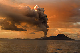
Tavurvur spewing ash in February 2009. To the right is Turangan, and Kombiu is partly visible behind Turangan.Elevation 688 m (2,257 ft) [1] Listing List of volcanoes in Papua New Guinea Location East New Britain,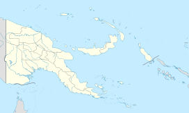
 Rabaul caldera
Papua New GuineaCoordinates 4°16′16″S 152°12′11″E / 4.27111°S 152.20306°ECoordinates: 4°16′16″S 152°12′11″E / 4.27111°S 152.20306°E[1] Geology Type Pyroclastic shield (active) Volcanic arc/belt Bismarck volcanic arc Last eruption 2010 [1]  Tavurvur
 Vulcan
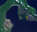
Rabaul caldera is a large volcano situated in East New Britain, Papua New Guinea. It derives its name from the town of Rabaul situated inside the caldera. The highest of its multiple peaks is 688 metres (2,257 ft).
The sub-vent of Tavurvur is the most visibly active, continuously throwing ash. In 1994 it, along with nearby Vulcan erupted and devastated Rabaul, however, due to planning for such a catastrophe, the townsfolk were prepared and only five people were killed. One of the deaths was caused by lightning, a feature of volcanic ash clouds.[citation needed]
In 1937 it erupted killing more than 500 people. This event lead to the founding of the Rabaul Volcano Observatory which watches over the many active volcanoes on Papua New Guinea.[2] One eruption over several days in March 2008 released a plume of ash and water vapor that drifted northwest over the Bismarck Sea.[3]

July 2010 Eruptions
Eruptions at Rabaul's Tavurvur cone resumed on 23 July 2010 after nearly seven months without ash emissions. As previously noted, Tavurvur was quiet between 1 January to 8 April 2010 (BGVN 35:02).
On 9 April 2010, the Rabaul Volcano Observatory (RVO) reported that deformation measurements at Rabaul caldera during the previous 3-4 months had showed an inflationary trend with a total of 4 cm of uplift. During 2-8 April seismicity was low and variable amounts of white vapor rose from Tavurvur cone.
According to RVO, Tavurvur cone erupted on 23 July 2010 after increased seismicity, likely beneath Tavurvur cone, was detected the previous day. The series began with a few small hybrid earthquakes, followed by small low-frequency earthquakes, then continuous volcanic tremor starting at 1034 on 22 July; the eruption followed at 1300 on 23 July.
The eruption began with discharge of diffuse white plumes, followed by pink-gray fumes with low ash content. A strong odor of hydrogen sulfide was noted, and a diffuse cloud rose 1 km and drifted NW. A few hours later, observers saw billowing gray clouds, accompanied by roaring and rumbling noises. Ashfall was reported in areas to the cone's NW and NNW.
RVO reported that, during 23-25 July, seismicity was variable. Ash emissions and ashfall continued in areas to the NW. Visibility remained poor in Rabaul town (3-5 km NW of Tavurvur) due to ash made airborne by the passage of moving vehicles. Ash emissions ceased on 25 July. Later that day and into 26 July only diffuse brown-tinted vapor plumes were emitted and seismicity was very low.
After the eruption of 23-25 July, GPS data showed deflation of Tavurvur cone. Seismicity was very low, and diffuse white plumes were emitted during 26-30 July.[4]
References
- ^ a b c "Rabaul". Global Volcanism Program, Smithsonian Institution. http://www.volcano.si.edu/world/volcano.cfm?vnum=0502-14=. Retrieved 2008-12-26.
- ^ Smithsonian Institution / SEAN (1989). Lindsay McClelland, Tom Simkin, Marjorie Summers, Elizabeth Nielsen, and Thomas C. Stein. ed. Global Volcanism 1975-1985. Prentice Hall, Englewood Cliffs NJ, and American Geophysical Union, Washington DC. pp. 180–189. ISBN 0-13-357203-X. http://www.volcano.si.edu/info/products/gvn10/gvn10.cfm.
- ^ "Rabaul Volcano, New Britain". NASA Earth Observatory. http://earthobservatory.nasa.gov/Newsroom/NewImages/images.php3?img_id=17969. Retrieved 20 March 2008.
- ^ "09/2010 (BGVN 35:09) After Months of Quiet, Ash-Bearing Eruptions on 23-25 July 2010". www.volcano.si.edu. 9/2010. http://www.volcano.si.edu/world/volcano.cfm?vnum=0502-14=&volpage=var#bgvn_3509. Retrieved 10/5/2011.
External links
-

Rabaul eruption plume, viewed from the Space Shuttle, September 1994
-

A space radar image of Rabaul caldera
-
A truecolour image of Rabaul Caldera from space
Categories:- Active volcanoes
- Subduction volcanoes
- Volcanic calderas
- Volcanoes of New Britain
- East New Britain Province
- VEI-6 volcanoes
- Pyroclastic shields
- Submarine calderas
- Papua New Guinea geography stubs


Wikimedia Foundation. 2010.