Mussau Island

Mussau Island
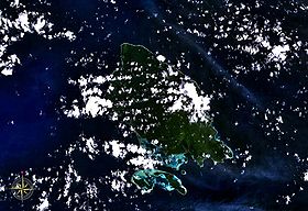
Mussau Island seen from space

Mussau Island is the largest island of St. Matthias Islands, Papua New Guinea, at 1°25′01″S 149°37′59″E / 1.417°S 149.633°E / -1.417; 149.633. It is one of the northernmost islands of Papua New Guinea.

References


Wikimedia Foundation. 2010.

Игры ⚽ Поможем написать курсовую

Look at other dictionaries:

  • Mussau Fantail — Conservation status Near Threatened (IUCN 3.1)[1] …   Wikipedia

  • Nissan Island — [1] Green Islands seen from space. Oval shaped Nissan Island is clearly visible in the center. Nissan Island (also Green Island) is the largest of the Green Islands of Papua New Guinea. It is located at …   Wikipedia

  • Manus Island — Manus Admiralty Islands …   Wikipedia

  • New Ireland (island) — For the political strategy of the Provisional IRA and Sinn Féin meaning New Ireland in English, see Éire Nua. New Ireland Native name: Niu Ailan New Ireland s main towns and nearby islands …   Wikipedia

  • Normanby Island (Papua New Guinea) — Normanby Topographic map of Normanby Island …   Wikipedia

  • Misima Island — Location within Louisiade Archipelago Misima Island from space …   Wikipedia

  • Woodlark Island — Woodlark Native name: Muyua, Muyuw Woodlark Islands …   Wikipedia

  • Lihir Island — Lihir Native name: Niolam NASA Space Shuttle image of Lihir Island …   Wikipedia

  • Daru Island — from space …   Wikipedia

  • Mailu Island — Central Province Papua New Guinea …   Wikipedia

Share the article and excerpts

Direct link
Do a right-click on the link above
and select “Copy Link”