- Nijkerk
-
Nijkerk — Municipality — 
Flag
Coat of arms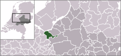
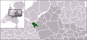
Coordinates: 52°13′N 5°29′E / 52.217°N 5.483°E Country Netherlands Province Gelderland Area(2006) - Total 72.05 km2 (27.8 sq mi) - Land 69.51 km2 (26.8 sq mi) - Water 2.53 km2 (1 sq mi) Population (1 January, 2007) - Total 38,879 - Density 559/km2 (1,447.8/sq mi) Source: CBS, Statline. Time zone CET (UTC+1) - Summer (DST) CEST (UTC+2)  Nijkerk (Dutch Low Saxon: Niekark) is a municipality and a city in the middle of the Netherlands, in the province of Gelderland.
Contents
Population centres
Achterhoek, Appel, De Veenhuis, Doornsteeg, Driedorp, Hoevelaken, Holk, Holkerveen, Kruishaar, Nekkeveld, Nijkerkerveen, Prinsenkamp, Slichtenhorst, 't Woud and Wullenhove.
Some people state that Groot Corlaer is a population centre on his own, but officially it's part of the city of Nijkerk
Transportation
Railway station: Nijkerk
The city of Nijkerk
 The Grote Kerk (Great Church) in Nijkerk
The name Nijkerk stems from Nieuwe Kerk (Dutch for New Church). This new church was built when the old chapel was destroyed by fire in 1221. Nijkerk was strategically located between the Duchy of Guelders (Dutch: Hertogdom Gelre) and the Bishopric of Utrecht. Because of this strategic location Nijkerk regularly was the scene of war, and in 1412 the village was completely destroyed. It was restored and Nijkerk received city rights in 1413. In 1421 the church that gave Nijkerk its name burnt down and was replaced; this happened several times, until a new church was built in the 18th century which still stands today. The organ in this church was built in 1756.
In the 18th century Nijkerk was a flourishing merchant city. Several inhabitants traveled to the New World, such as Arent van Curler and Kiliaen van Rensselaer and founded new cities.
Since World War II Nijkerk is growing fast. It lies on the border of the IJsselmeer which allows for transportation of goods via ships, and the intersection of two major motorways, the A1 and A28. This allowed local industries to grow, and also caused a lot of people who work in the nearby Randstad to move to the more quiet Nijkerk. Also the easy access to the Veluwe is a contributing factor to this growth.
Politics
In 2000, the municipalities of Nijkerk and Hoevelaken merged to form the new municiplity of Nijkerk. Since then the city council has 25 seats. Currently (April 2010) the seats are divided as follows:
Party Number of seats CDA 8 Christen-Unie and SGP 5 VVD 3 Progressief 21 4 Lokaal Belang 4 PPP 1 Progressief 21 is a local party combining the local chapters of D66, GroenLinks and PvdA. The last two parties are local parties that have no national connection.
On August 24th, 2011, the municipality announced that Nijkerk had passed the mark of 40,000 inhabitants. This should mean that after the next election the city council would be extended by 2 seats, but because of government spending reductions this is not yet certain.[1]
Climate
Climate data for Nijkerk Month Jan Feb Mar Apr May Jun Jul Aug Sep Oct Nov Dec Year Average high °C (°F) 5
(41)5
(41)8
(46)12
(54)17
(63)19
(66)21
(70)21
(70)18
(64)13
(55)8
(46)6
(43)12.8
(55.0)Average low °C (°F) 0
(32)0
(32)1
(34)2
(36)7
(45)10
(50)12
(54)12
(54)9
(48)6
(43)3
(37)1
(34)5.3
(41.5)Precipitation mm (inches) 70
(2.76)45
(1.77)65
(2.56)45
(1.77)60
(2.36)70
(2.76)65
(2.56)60
(2.36)65
(2.56)75
(2.95)80
(3.15)85
(3.35)785
(30.91)Sunshine hours 52 83 114 160 205 188 197 193 132 105 58 41 1,528 Source: [2] Famous people from Nijkerk
- Bernardus Johannes Alfrink (1900-1987), Cardinal
- Arent Van Curler (1620-1667), founder of Schenectady, New York
- Christiaan Eijkman (1858-1930), Nobel Prize winner
- James Kwast (1852-1927), pianist and teacher
- Henri Nouwen (1932-1996), priest and writer
- Kiliaen van Rensselaer (before 1596 - after 1642), merchant and Hudson Valley patroon.
Twin town
References
- ^ http://www.nijkerk.eu/document.php?m=3&fileid=6519&f=a32450a43754f02e311ac1bb6c145835&attachment=1&c=2637 Municipal press release (dutch) about 40,000th inhabitant
- ^ "Het Weer in Nijkerk. Bekijk Weersverwachting van Nijkerk | Zoover". Zoover.nl. http://www.zoover.nl/nederland/gelderland/nijkerk/weer. Retrieved 2011-02-12.
External links
Aalten · Apeldoorn · Arnhem · Barneveld · Berkelland · Beuningen · Brummen · Bronckhorst · Buren · Culemborg · Doesburg · Doetinchem · Druten · Duiven · Ede · Elburg · Epe · Ermelo · Geldermalsen · Groesbeek · Harderwijk · Hattem · Heerde · Heumen · Lingewaal · Lingewaard · Lochem · Maasdriel · Millingen aan de Rijn · Montferland · Neder-Betuwe · Neerijnen · Nijkerk · Nijmegen · Nunspeet · Oldebroek · Oost Gelre · Oude IJsselstreek · Overbetuwe · Putten · Renkum · Rheden · Rijnwaarden · Rozendaal · Scherpenzeel · Tiel · Ubbergen · Voorst · Wageningen · West Maas en Waal · Westervoort · Wijchen · Winterswijk · Zaltbommel · Zevenaar · Zutphen

See also: Netherlands · Provinces · Municipalities Coordinates: 52°13′N 5°29′E / 52.217°N 5.483°E
Categories:- Municipalities of Gelderland
- Populated places in Gelderland
- Cities in the Netherlands
- Gelderland geography stubs


Wikimedia Foundation. 2010.