- Overbetuwe
-
Overbetuwe — Municipality — 
Flag
Coat of arms
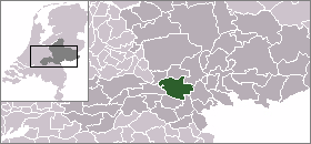
Coordinates: 51°55′N 5°51′E / 51.917°N 5.85°ECoordinates: 51°55′N 5°51′E / 51.917°N 5.85°E Country Netherlands Province Gelderland Government - Mayor Elisabeth Tuijnman Area(2006) - Total 115.18 km2 (44.5 sq mi) - Land 109.59 km2 (42.3 sq mi) - Water 5.59 km2 (2.2 sq mi) Population (1 January, 2010) - Total 45,566 - Density 394/km2 (1,020.5/sq mi) Source: CBS, Statline. Time zone CET (UTC+1) - Summer (DST) CEST (UTC+2)  Overbetuwe is a municipality in the province of Gelderland in the Netherlands. It was formed on 1 January 2001 as a merger of three former municipalities: Elst, Heteren and Valburg. Overbetuwe is bordered in the north by the river Rhine and in the south by the river Waal. The city hall is located in Elst, the largest town in the municipality. Together with eighteen other municipalities it forms the 'Knooppunt Arnhem-Nijmegen' (English: 'Arnhem-Nijmegen conurbation'), or simply 'KAN', which is a regional collaboration.
Contents
Towns
Town Inhabitants (2010) Andelst 1695 Driel 3600 Elst 20651 Hemmen 195 Herveld 2972 Heteren 5145 Homoet 86 Loenen 47 Oosterhout (partly) 2310 Randwijk 1468 Slijk-Ewijk 493 Valburg 1673 Zetten 5278 Transportation
Because of its central location between the cities of Nijmegen and Arnhem, many inhabitants of Overbetuwe commute between these cities. Three major highways are situated in the municipality; the A50, A15 and A325. Overbetuwe has two railway stations: Elst and Zetten-Andelst. Besides these two existing railway lines, a controversial freight line called the Betuweroute has been operational from 2007.
Politics
The mayor of Overbetuwe is Elisabeth Tuijnman. The distribution of council seats after the 2010 elections is shown here.
Party Seats CDA 7 PvdA 4 Gemeentebelangen Overbetuwe 5 VVD 5 D66 5 GroenLinks 2 ChristenUnie 1 External links
Aalten · Apeldoorn · Arnhem · Barneveld · Berkelland · Beuningen · Brummen · Bronckhorst · Buren · Culemborg · Doesburg · Doetinchem · Druten · Duiven · Ede · Elburg · Epe · Ermelo · Geldermalsen · Groesbeek · Harderwijk · Hattem · Heerde · Heumen · Lingewaal · Lingewaard · Lochem · Maasdriel · Millingen aan de Rijn · Montferland · Neder-Betuwe · Neerijnen · Nijkerk · Nijmegen · Nunspeet · Oldebroek · Oost Gelre · Oude IJsselstreek · Overbetuwe · Putten · Renkum · Rheden · Rijnwaarden · Rozendaal · Scherpenzeel · Tiel · Ubbergen · Voorst · Wageningen · West Maas en Waal · Westervoort · Wijchen · Winterswijk · Zaltbommel · Zevenaar · Zutphen

See also: Netherlands · Provinces · Municipalities Categories:- Municipalities of Gelderland
- Netherlands stubs


Wikimedia Foundation. 2010.