- Nunspeet
-
Nunspeet — Municipality — 
Flag
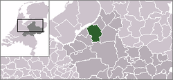
Coat of armsCoordinates: 52°23′N 5°48′E / 52.383°N 5.8°E Country Netherlands Province Gelderland Area(2006) - Total 129.49 km2 (50 sq mi) - Land 128.73 km2 (49.7 sq mi) - Water 0.76 km2 (0.3 sq mi) Population (1 January 2007) - Total 52,368 - Density 206/km2 (533.5/sq mi) Source: CBS, Statline. Time zone CET (UTC+1) - Summer (DST) CEST (UTC+2)  Nunspeet is a municipality and town in the central Netherlands. It has been an agricultural site since prehistoric times. It contains a number of villages, like Oosteinde, Westeinde, Hulshorst, Elspeet, Vierhouten and Hoophuizen. Nunspeet has a vivid historical foundation, called Nuwenspete.[1] In 1973 Nunspeet became its own separate municipality after having been part of Ermelo before.
Contents
Recreation
Nunspeet is a popular tourists site because it is surrounded by woods, holiday resorts, and the town center located around the main market square.
Nunspeet is situated on the shore of the Veluwemeer (Veluwe lake) which makes it popular for water leisure. There is also a small lake called "de Zandenplas" which is a popular holiday resort.
Other tourist attractions include the weekly market and the town festival, De nacht van Nunspeet (Nunspeet Night) and the Eibertjesmarkt (Eibertjes market), as well as an annual sporting event called "de Keiler".
Population centres
- Nunspeet
- Elspeet
- Hulshorst
- Vierhouten
Transportation
- Railway station: Nunspeet
References
External links
Aalten · Apeldoorn · Arnhem · Barneveld · Berkelland · Beuningen · Brummen · Bronckhorst · Buren · Culemborg · Doesburg · Doetinchem · Druten · Duiven · Ede · Elburg · Epe · Ermelo · Geldermalsen · Groesbeek · Harderwijk · Hattem · Heerde · Heumen · Lingewaal · Lingewaard · Lochem · Maasdriel · Millingen aan de Rijn · Montferland · Neder-Betuwe · Neerijnen · Nijkerk · Nijmegen · Nunspeet · Oldebroek · Oost Gelre · Oude IJsselstreek · Overbetuwe · Putten · Renkum · Rheden · Rijnwaarden · Rozendaal · Scherpenzeel · Tiel · Ubbergen · Voorst · Wageningen · West Maas en Waal · Westervoort · Wijchen · Winterswijk · Zaltbommel · Zevenaar · Zutphen

Coordinates: 52°23′N 5°48′E / 52.383°N 5.8°E
Categories:- Municipalities of Gelderland
- Populated places in Gelderland
- Gelderland geography stubs
Wikimedia Foundation. 2010.

