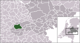
Geldermalsen

Geldermalsen

Infobox Settlement
official_name = Geldermalsen


mapsize = 280px
subdivision_type = Country
subdivision_name = Netherlands
subdivision_type1 = Province
subdivision_name1 = Gelderland
area_footnotes = (2006)
area_total_km2 = 101.67
area_land_km2 = 99.70
area_water_km2 = 1.97
population_as_of = 1 January, 2007
population_note = Source: CBS, [http://statline.cbs.nl/ Statline] .
settlement_type = Municipality
population_total = 26241
population_density_km2 = 263
timezone = CET
utc_offset = +1
timezone_DST = CEST
utc_offset_DST = +2

. The municipality Geldermalsen was formed on the 1st of januari 1978 when former municipalities Beesd, Buurmalsen, Deil and Geldermalsen were joined. The new municipality with approximately 10.173 square hectare (100 x 100 m2) one of the largest municipalities in the Western Betuwe. On the first of January 2008 the municipality had 26.295 inhabitants. They live across in one of the eleven villages that form Geldermalsen.

Population centres

Acquoy, Beesd, Buurmalsen, Deil, Enspijk, Geldermalsen , Gellicum, Meteren, Rhenoy, Rumpt and Tricht.

Geography

Through Geldermalsen flows the river named the Linge, which provides water fun for many.

External links

* [http://www.geldermalsen.nl Official Website]
* [http://www.plattegronden.nl/gemeentegeldermalsen/ Map]


Wikimedia Foundation. 2010.

Игры ⚽ Поможем написать реферат

Look at other dictionaries:

  • Geldermalsen — Héraldique …   Wikipédia en Français

  • Geldermalsen — Gemeinde Geldermalsen Flagge Wappen Provinz …   Deutsch Wikipedia

  • Geldermalsen — Original name in latin Geldermalsen Name in other language Gel dermalsen, Geldermalsen, Гельдермалсен State code NL Continent/City Europe/Amsterdam longitude 51.88083 latitude 5.28889 altitude 5 Population 25734 Date 2010 01 29 …   Cities with a population over 1000 database

  • Geldermalsen — Sp Gèldermalsenas Ap Geldermalsen L Nyderlandai …   Pasaulio vietovardžiai. Internetinė duomenų bazė

  • Geldermalsen — Sp Gèldermalsenas Ap Geldermalsen L Olandija …   Pasaulio vietovardžiai. Internetinė duomenų bazė

  • Geldermalsen (town) — Dutch town locator maps mun town caption = The town centre (red) and the statistical district (light green) of Geldermalsen in the municipality of Geldermalsen.Geldermalsen is a town in the Dutch province of Gelderland. It is a part of the… …   Wikipedia

  • Geldermalsen railway station — Infobox NS station station = Geldermalsen stationsnaam = Geldermalsen latdeg=51 |latmin=53 |latsec=2 |londeg=5 |lonmin=16 |lonsec=15Geldermalsen is a railway station in the town of Geldermalsen, the Netherlands.HistoryThe station opened in 1868,… …   Wikipedia

  • Gare de Geldermalsen — Geldermalsen Vue extérieure sur la gare Localisation Pays Pays Bas Ville Geldermalsen Coordonnées géog …   Wikipédia en Français

  • Gemeente Geldermalsen — Admin ASC 2 Code Orig. name Gemeente Geldermalsen Country and Admin Code NL.03.0236 NL …   World countries Adminstrative division ASC I-II

  • Beesd — 51°53′15″N 5°11′28″E / 51.8875, 5.19111 …   Wikipédia en Français

Share the article and excerpts

Direct link
Do a right-click on the link above
and select “Copy Link”