- Montferland
-
Montferland — Municipality —
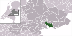
Coat of armsCoordinates: 51°56′N 6°09′E / 51.933°N 6.15°E Country Netherlands Province Gelderland Area(2006) - Total 106.54 km2 (41.1 sq mi) - Land 105.63 km2 (40.8 sq mi) - Water 0.92 km2 (0.4 sq mi) Population (1 January, 2007) - Total 35,017 - Density 332/km2 (859.9/sq mi) Source: CBS, Statline. Time zone CET (UTC+1) - Summer (DST) CEST (UTC+2)  Montferland is a municipality in Gelderland, the Netherlands. It was created on 1 January 2005 from the former neighboring municipalities of Bergh and Didam.
Population centres
Formerly from Bergh
- 's-Heerenberg
- Stokkum
- Zeddam
- Braamt
- Kilder
- Lengel
- Loerbeek
- Beek
- Azewijn
- Vethuizen
- Wijnbergen
Formerly from Didam
- Didam
- Greffelkamp
- Holthuizen
- Loil
- Nieuw-Dijk
- Oud-Dijk
Loil
Loil is a village with a population of about 1,500 people. Located next to Didam and Nieuw-Dijk, it is part of the new municipality Montferland. Loil is known for its big celebration of carnival (second biggest parade in the Netherlands). Loil has an active social life, with a lot of sports clubs like football, volleyball (s.v. Loil, established in 1956). It also has a music organization Amicitia, established in 1913, and a shooting club Schutterij Loil-Vooruit. The village has a windmill, a Roman Catholic parish church and an elementary school, named after Saint Joseph.
The first time Loil was mentioned in official papers was in 1178, although the name was Loel back then. Loil consists of mostly farmerland in a rural area.
External links
- Official Website
- Kilder's website
- Sprinkhanen
- Official website of Loil
- Carnaval organization 'De Vrolijke Drammers'
Aalten · Apeldoorn · Arnhem · Barneveld · Berkelland · Beuningen · Brummen · Bronckhorst · Buren · Culemborg · Doesburg · Doetinchem · Druten · Duiven · Ede · Elburg · Epe · Ermelo · Geldermalsen · Groesbeek · Harderwijk · Hattem · Heerde · Heumen · Lingewaal · Lingewaard · Lochem · Maasdriel · Millingen aan de Rijn · Montferland · Neder-Betuwe · Neerijnen · Nijkerk · Nijmegen · Nunspeet · Oldebroek · Oost Gelre · Oude IJsselstreek · Overbetuwe · Putten · Renkum · Rheden · Rijnwaarden · Rozendaal · Scherpenzeel · Tiel · Ubbergen · Voorst · Wageningen · West Maas en Waal · Westervoort · Wijchen · Winterswijk · Zaltbommel · Zevenaar · Zutphen

See also: Netherlands · Provinces · Municipalities Coordinates: 51°56′00″N 6°09′00″E / 51.933333333333°N 6.15°E
Categories:- Municipalities of Gelderland
- Gelderland geography stubs
Wikimedia Foundation. 2010.


