- Downtown Markham, Ontario
-
- Not to be confused with Markham Centre.
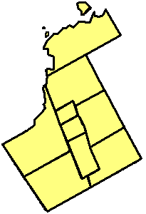
Downtown Markham — Downtown — Motto: Settle for everything. Downtown Markham's location within York Region.

Coordinates: 43°51′N 79°19′W / 43.85°N 79.32°WCoordinates: 43°51′N 79°19′W / 43.85°N 79.32°W Country  Canada
Province  Ontario
Regional Municipality York Town Markham District Markham Centre Planned 1992 [1] Completion date 2030 Area[1] – Total 0.98 km2 (0.4 sq mi) Time zone Eastern Standard Time (UTC-5) – Summer (DST) Eastern Daylight Time (UTC-4) Canadian postal codes L6G Area code(s) 905, 289 Website Downtown Markham Downtown Markham is a community under construction within the Town of Markham, Ontario, Canada. The community is located within the subdivision of Markham Centre, and is proposed to serve as the heart of Markham. Downtown Markham, once completed, will serve as a CBD to the town, hiring as many as 16,000 employees [2][3], as well as a home to approximately 10,000 [4] with the proposed medium to high density residential structures. The community is being developed, built and wholly financed by The Remington Group Inc. Contrary to popular belief, to date (2009), Downtown Markham has not used provincial or municipal funding for any construction.[2] The downtown features Montgomery High Street, which is planned to be Markham's premier retail destination [5].
Occupancy begins in April 2009, when the first "set" of condos are finished its completion.[6]
Contents
Downtown Markham and Markham Centre
Downtown Markham will be a community within Markham Centre, and will consist of mostly commercial buildings.
Downtown Markham refers to an area south of Highway 7, west of Kennedy Road / Main Street Unionville, east of Warden Avenue, and north of Highway 407 ETR.
On the other hand, Markham Centre refers to a broader area. Markham Centre is bounded north to Apple Creek Boulevard / Carlton Road, east to Kennedy Road, west to Rodick Road, and south to 14th Avenue.
History
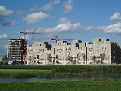 Downtown Markham construction site in 2009.
The community was planned in 1992. The Town of Markham has approved the plan, according to Markham's former mayor, Donald Cousens.[2] It was planned out that the community will be entirely self-sustained, transit-oriented, using Smart Growth. Construction began in 2005, when Enterprise Drive was completed.
Strategies of Downtown Markham
Downtown Markham is using a development strategy named smart growth. The community will try to limit urban sprawl by creating a denser urban centre. The urban centre is planned to be a transit-oriented community, with everything close by and fully transit dependent.[3] In addition, the community was also planned to have be environmentally sustainable as well.
The community was planned by the Town of Markham, in co-operation with the Remington Group. The Remington Group is mainly in charge of constructing most of the structures across this new community.
According to the plan approved by the town council, the community will contain structures such as condos, townhouses and office buildings.[2] Some of these structures have already begun construction. In particular, the Honeywell Office building has already been completed.
Downtown Markham has been nominated as the country's largest mixed-used development, as well as North America's largest LEED (leadership-in-energy-and-environmental-design) registered development.[6]
Transportation
 Warden Vivastation
The primary modes of transportation in Downtown Markham are: Regional Roads, municipal roads, a toll highway, bus rapid transit, and GO Trains.[3]
York Regional Roads
The community is bounded with three York Regional Roads, which are numbered as 3 (Kennedy Road), 7 (Highway 7), and 65 (Warden Avenue).
Municipal Roads
Most of the roads across the community are municipally funded local roads. The only two roads serving as major arterials are Enterprise Drive and Birchmount Road. Both roads have four lanes and a median divider.
Toll Highway
Highway 407 serves the community with exits on Warden Avenue and Kennedy Road. The highway leads east to Pickering and west to Hamilton.
Bus Rapid Transit
The community is served by the Warden, Enterprise and Unionville stops on the VIVA bus rapid transit system. Warden and Enterprise are served by three lines: Viva Purple, Viva Green, and Viva Pink, while Unionville Station is only served by Viva Pink. As of 2011, Viva Purple is the only line with all-day service, the other lines operate only during rush hour. It is scheduled that when Downtown Markham is fully functional and occupied, Viva Green will return to full service. The community is anticipated to be highly dependent on these transit routes, as part of the planned smart growth.
Viva Purple connects the locale to Cornell and York University; Viva Green connects the locale to Don Mills Station and Cornell; Viva Pink connects the locale to North York City Centre.
Other bus routes that serve the area include:
- TTC 68 Warden
- YRT 8 Kennedy
- YRT 1 Highway 7
GO Transit
GO Transit also serves the area. Unionville Station is located within Downtown Markham. It is on the Stouffville Line, which operates only during rush hours. The GO Train connects the locale to Stouffville and Downtown Toronto.
Environmental Sustainability
The community reserves 72 acres (290,000 m2) as a natural reserve, which includes an ecologically sensitive area, Rouge River.
References
- ^ a b "Downtown Markham:About". 2006. http://www.downtownmarkham.ca/about/index.php. Retrieved 2007-10-12.
- ^ a b c d Guelph Civic League. "Downtown Markham Makeover". http://www.guelphcivicleague.ca/page.php?p=55. Retrieved 2008-06-16.
- ^ a b c The Toronto Star (2007-08-11). "Digging for an elusive dream". The Star. http://www.thestar.com/comment/columnists/article/245107. Retrieved 2008-06-16.
- ^ Remington Group, and the Town of Markham (March 2006). "Downtown Markham Facts at a glance". http://www.downtownmarkham.ca/pdfs/FS-At%20a%20Glance.pdf. Retrieved 2007-10-12.
- ^ "Downtown Markham. Montgomery High Street.". http://www.downtownmarkham.ca/urbantopia/index.php. Retrieved 2008-04-17.
- ^ a b 100 Thousand Club. "New York. Paris. London. Toronto?". http://www.downtownmarkham.ca/pdfs/100K%20ClubFINAL_FINAL_Feb28,2008.pdf. Retrieved 2008-06-16.
Topics on Markham, OntarioMain topicsFounder • Government • History • Mayor • Previous Mayors • York Region (portal) • Markham municipal election, 2010 • Markham Ward 3 By-election, 2009 • Markham municipal election, 2006
TransportationCommunitiesAngus Glen • Armadale • Berczy Village • Box Grove • Buttonville • Cachet • Cashel • Cedar Grove • Cornell • Dickson Hill • Downtown Markham • Gormley • Greensborough • Legacy • Locust Hill • Old Markham Village • Markham Centre • Milliken • Mongolia • Quantztown • Unionville • Thornhill • Underwood • Vinegar Hill • Wismer Common
Education / SchoolsElementary: All Saints • Armadale • Ashton Meadows • Boxwood Public School • Castlemore • Central Park • Boxwood • San Lorenzo Ruiz • William Berczy
Secondary: Brother André • McGivney • Markham District • Markville • Middlefield • Milliken Mills • St. Augustine • St. Robert • Thornhill • Thornlea • Trudeau • Unionville
Post Secondary: Seneca College: Buttonville Airport Campus, Markham CampusAthletics, Recreation, and ShoppingAthletics: Markham Waxers • Sports
Recreation: Angus Glen Golf Club • Cedar Brae Golf & Country Club • Parks
Shopping: Markville Mall • Pacific Mall • Market VillageAttractionsMedia, and ServicesNotable PeopleBill Crothers • Brad May • Sean Morley • Ken Pereira • Tammy Sutton-Brown • Steve Thomas • Raffi Torres • Stephen Weiss • Steve Byers • Emmanuelle Chriqui • Hayden Christensen • Talan Torriero • Justin Peroff
Sister CitiesCary, North Carolina • Nördlingen, Germany • Pearland, Texas • Wuhan, China
Communities of Markham Angus Glen • Armadale • Berczy Village • Box Grove • Brown's Corners • Buttonville • Cachet • Cashel • Cathedraltown • Cedar Grove • Cornell • Dickson Hill • Dollar • Downtown Markham • German Mills • Greensborough • Hagerman's Corners • Langstaff • Legacy • Locust Hill • Markham • Markham Village • Milliken • Milnesville • Mongolia • Mount Joy • Quantztown • Raymerville - Markville East • Rouge Fairways • Sherwood - Amber Glen • Thornhill • Underwood • Unionville • Victoria Square • Vinegar Hill • Wismer Commons • Woodbine NorthCommunities in other York Region municipalities: King • Markham • Richmond Hill • Vaughan • Whitchurch–StouffvilleCategories:- Neighbourhoods in Markham, Ontario


Wikimedia Foundation. 2010.