- Gormley, Ontario
-
Gormley — Unincorporated community — A sign found on Gormley Road East.
Coordinates: 43°56′27″N 79°22′55″W / 43.94083°N 79.38194°W Country Canada Province Ontario Regional municipality York Region Town Whitchurch-Stouffville Amalgamation (With Town of Stouffville)
1 January 1971Government - Type Municipality - Mayor Wayne Emmerson - Councillor Clyde Smith (Ward 3) Elevation 257 m (843 ft) Time zone EST (UTC−5) - Summer (DST) EDT (UTC−4) Forward sortation area L0H Area code(s) 905 and 289 NTS Map 030M14 GNBC Code FBIOH Gormley is a hamlet in York Region, Ontario, Canada that overlaps parts of Richmond Hill, and Whitchurch-Stouffville, two municipalities within the Greater Toronto Area. It was divided into two parts due to the construction of Highway 404. A portion of Gormley situated within Richmond Hill's political boundaries is subject to "Heritage Conservation District" controls.[1] A post office in Gormley (East) serves as the mailing address for the Whitchurch-Stouffville communities of Bethesda, Gormley, Preston Lake, Vandorf, and Wesley Corners.[verification needed]
Gormley Road East, on the south side of Stouffville Road, leads to Gormley Court and a dead-end at the railroad tracks. On the other side of the tracks, accessible by Leslie Street, is Gormley Road West. The community used to have a significant railroad station (see picture below). Many of the houses are approximately 100 years old. The community celebrated its 100th anniversary in 2005.
History
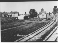 New Gormley from the South in the early 20th Century. Seen from left to right: blacksmith shop, David and Jacob Heise's double house, driveshed, railway station, North American Cement Block and Tile Company office.[2]
The community was named after its first postmaster, James Gormley, who served from 1851 to 1876.[3] The hamlet originally straddled the townships of Markham to the south and Whitchurch to the north, both in the County of York.[4]
The old community of Gormley is situated east of the Highway 404 at the corner of Woodbine Avenue and Stouffville Road.
New Gormley or West Gormley, is the area near Leslie St and Stouffville Road.[5]
A rail line owned by Canadian National Railway runs through West Gormley; it is CN's primary freight corridor connecting Greater Toronto to Northern Ontario and Western Canada. The construction of the new GO Transit commuter train and bus station will begin in the Fall of 2011.[6]
A future challenge to the community of Gormley is the proposed development of an international airport immediately south-east of Whitchurch-Stouffville (the Pickering Airport lands). Under the current plan, the approach for one of the three landing strips would be directly over Gormley, with planes descending above the hamlet from an elevation of 521 metres to 480 metres. The plan anticipates 11.9 million passengers per year (or 32,600 per day) by 2032.[7] A "Needs Assessment Study" was completed by the Greater Toronto Airports Authority for the federal government in May 2010. After a "due diligence review," Transport Canada released the report in July 2011.[8]
Companies and attractions
The Town of Whitchurch-Stouffville Museum is located in Vandorf, which is north of Gormley, on Woodbine Avenue.[9] A golf course formerly known as Gormley Greens is now called Station Creek, which is situated north of Stouffville Road off Woodbine Avenue.
- Digital Leisure
- Bizzone
- Famous Sam's
- Canbrands Specialty Foods
- Station Creek Golf Club
- Golden Ridge Driving Range
- Gormley Arts and Leisure Centre
References
- ^ Adam McLean, Rift forms in Gormley over Conservation District, York Region.com (Oct. 15, 2009).
- ^ Robert M. Stamp, New Gormley Station, Early 20th Century, Early Days in Richmond Hill: A History of the Community to 1930 (Electronic Edition).
- ^ For a complete history of Gormley, see Jean Barkey et al, Whitchurch Township (Erin, ON: Boston Mills, 1993), 57-61; also Isabel Champion, ed., Markham: 1793-1900 (Markham, ON: Markham Historical Society, 1979), pp. 240-243; 337.
- ^ See the detailed 1878 maps, "Township of Whitchurch," and the "Township of Markham," Illustrated historical atlas of the county of York and the township of West Gwillimbury & town of Bradford in the county of Simcoe, Ont. (Toronto: Miles & Co., 1878).
- ^ Robert M. Stamp, Early Days in Richmond Hill: A History of the Community to 1930 (Electronic Edition). See also Maurice Smith, "A Hamlet Divided," Stouffville Free Press, Oct. 26, 2011.
- ^ Cf. New Gormley GO Station, 2011.
- ^ Cf. Transport Canada, Plan Showing Pickering Airport Site; also Greater Toronto Airports Authority, Pickering Airport Draft Plan Report, 2002. By comparison, Toronto Pearson International Airport had 32.3 million passengers in 2008, with an average of 1,179 "aircraft movements" per day (GTTA, Toronto Pearson Fast Facts.
- ^ Transport Canada, News Release: "Transport Canada releases findings of the 2010 Pickering Lands Needs Assessment Study," July 11, 2011.
- ^ Whitchurch-Stouffville Museum, Town of Whitchurch-Stouffville
Bayview Hill · Bayview North · East Beaver Creek · Dollar · Doncrest · Elgin Mills · Gormley · Jefferson · Jefferson Forest · Lake Wilcox · Langstaff · Oak Ridges · Richmond Hill · Richvale · Temperanceville · Tower HillCommunities in other York Region municipalities: King • Markham • Richmond Hill • Vaughan • Whitchurch–Stouffville Communities of Whitchurch-Stouffville, Ontario Ballantrae · Bethesda · Bloomington · Gormley · Lemonville · Lincolnville · Musselman Lake · Pine Orchard · Pleasantville · Preston Lake · Ringwood · Stouffville · Vandorf · Wesley CornersCommunities in other York Region municipalities: King • Markham • Richmond Hill • Vaughan • Whitchurch–Stouffville Coordinates: 43°56′27″N 79°22′55″W / 43.94083°N 79.38194°W
Categories:- Communities in Whitchurch-Stouffville
- Neighbourhoods in Richmond Hill, Ontario

Wikimedia Foundation. 2010.