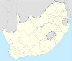
- Vanderkloof Dam
-
Vanderkloof Dam Official name Vanderkloof Dam Location Northern Cape, South Africa Coordinates 29°59′32″S 24°43′54″E / 29.992222°S 24.731667°E Construction began 1973 Opening date 1977 Dam and spillways Height 108 metres (354 ft)[2] Length 765 metres (2,510 ft)[1] Impounds Orange River Reservoir Creates Vanderkloof Dam Reservoir Capacity 3,200,000,000 cubic metres (1.1×10¹¹ cu ft)[1] Surface area 133.402 square kilometres (51.507 sq mi) The Vanderkloof Dam (originally the P.K. Le Roux Dam) is situated approximately 130km down stream from Gariep Dam and is fed by the Orange River, South Africa's largest river. Vanderkloof Dam is the second largest dam in South Africa, boasting the highest dam wall in the country at 108m. The dam was commissioned in 1977, has a capacity of 3,200,000,000 cubic metres (1.1×10¹¹ cu ft), a surface area of 133,402 square kilometres (51,507 sq mi), and the dam wall is 108 metres (354 ft) high. However the Orange is not the only river flowing into this giant dam: there are the Berg River, 2 unnamed streams come in fron the direction of Reebokrand, the Knapsak River, Paaiskloofspruit, Orange River, Seekoei River, Kattegatspruit and the Hondeblaf River, in a clockwise direction.
External links
See also
- Orange River
- List of reservoirs and dams in South Africa
- List of rivers of South Africa
References
- ^ a b "VANDERKLOOF DAM". Department of Water Affairs and Forestry (South Africa). http://www.dwaf.gov.za/orange/Mid_Orange/vanderkl.htm. Retrieved 2009-05-27.
- ^ "Vanderkloof Dam". http://www.vanderkloofdam.co.za/. Retrieved 2009-05-27.
Electricity generation Concepts Availability factor · Baseload · Black start · Capacity factor · Demand factor · Demand management · EROEI · Grid storage · Intermittency · Load following · Nameplate capacity · Peak demand · Repowering · Spark spreadSources Technology Distribution Policies Carbon offset · Coal phase out · Ecotax · Energy subsidies · Feed-in tariff · Net metering · Pigovian tax · Renewable Energy Certificates · Renewable energy payments · Renewable energy policyCategories: Electric power distribution · Electricity economics · Power station technology · Portals: Energy · Sustainable developmentCategories:- Orange River
- Dams in South Africa
- Hydroelectric power stations in South Africa
- Hydroelectric power plant stubs
- South African dam stubs
Wikimedia Foundation. 2010.

