- Trans-Mexican Volcanic Belt
-
For other uses, see Sierra Nevada (disambiguation).
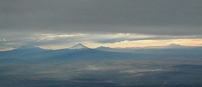
The Trans-Mexican Volcanic Belt (Eje Volcánico Transversal) also known as the Transvolcanic Belt and locally as the Sierra Nevada (Snowy Mountain Range),[1] is a volcanic belt that extends 900 km from west to east across central-southern Mexico. Several of its highest peaks have snow all year long, and during clear weather, they are visible to a large proportions of those who live in Mexico on the many high plateaus from which these volcanoes rise.
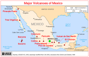
From the west, it runs from Jalisco east through northern Michoacán, southern Guanajuato, southern Querétaro, México State, southern Hidalgo, the Distrito Federal, northern Morelos, Puebla and Tlaxcala, to central Veracruz. The Mexican Plateau lies to the north, bounded by the Sierra Madre Occidental to the west and Sierra Madre Oriental to the east. The Cofre de Perote and Pico de Orizaba volcanoes, in Puebla and Veracruz, mark the meeting of the Trans-Mexican Volcanic Belt with the Sierra Madre Oriental. To the south, the basin of the Balsas River lies between the Trans-Mexican Volcanic Belt and the Sierra Madre del Sur. This area is also a distinct physiographic province of the larger Sierra Madre System physiographic division.
The highest point, also the highest point in Mexico, is Pico de Orizaba (5,636 metres (18,491 ft)) also known as Citlaltépetl, located at 19°01′N 97°16′W / 19.017°N 97.267°W. This, and several of the other high peaks, are active or dormant volcanoes; other notable volcanoes in the range include (from west to east) Nevado de Colima (4,339 metres (14,236 ft)), Parícutin (2,774 metres (9,101 ft)), Nevado de Toluca (4,577 metres (15,016 ft)), Popocatépetl (5,452 metres (17,887 ft)), Iztaccíhuatl (5,286 metres (17,343 ft)), Matlalcueitl (4,461 metres (14,636 ft)) Cofre de Perote (4,282 metres (14,049 ft)) and Sierra Negra, a companion of the Pico de Orizaba (4,580 metres (15,030 ft)).
The mountains are home to the Trans-Mexican Volcanic Belt pine-oak forests, one of the Mesoamerican pine-oak forests ecoregions.
The Trans-Mexican Volcanic Belt has many endemic species including the Transvolcanic Jay (Aphelocoma ultramarina).
References
- ^ Delgado de Cantú, Gloria M. (2003). México, estructuras, política, económica y social. Pearson Educación. ISBN 9789702603573. http://books.google.com/books?id=DZDTWsJGsY8C&pg=PA15.
- A. Gómez-Tuena, Ma.T. Orozco-Esquivel, and L. Ferrari Igneous Petrogenesis of the Trans-Mexican Volcanic Belt, Ch 5, pp. 129-182, in Susana A. Alaniz-Álvarez and Angel F. Nieto-Samaniego, eds., Geology of México, Geological Society of America Special Paper 422, 2007 ISBN 978-0813724225
External links
- Mexico Volcanoes and Volcanics USGS
- Trans-Mexican Volcanic Belt pine-oak forests (World Wildlife Fund)
Subfields of physical geography  Categories:
- Trans-Mexican Volcanic Belt
- Mountain ranges of Mexico
- Central Mexico
- Volcanic belts
- Volcanism of Mexico
- Geography of Michoacán
- Geography of Puebla
- Geography of Veracruz
- Physiographic provinces
- Regions of Mexico
Wikimedia Foundation. 2010.


