- Puebla
Infobox Settlement
name = State of Puebla
other_name =
native_name =
nickname =
settlement_type =
motto =
imagesize =
image_caption =
flag_size = 140px
image_
seal_size =
image_shield = Escudo de Puebla.svg
shield_size = 80px
city_logo =
citylogo_size =
mapsize =
map_caption = Location within Mexico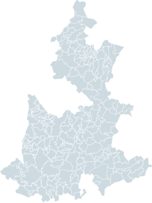
mapsize1 = 180px
map_caption1 = Municipalities of Puebla
image_dot_
dot_mapsize =
dot_map_caption =
dot_x = |dot_y =
pushpin_
pushpin_label_position =
pushpin_map_caption =
pushpin_mapsize =
subdivision_type = Country
subdivision_name = MEX
subdivision_type1 = Capital
subdivision_name1 = Puebla
subdivision_type2 = Municipalities
subdivision_name2 = 217
subdivision_type3 = Largest Cities
subdivision_name3 =PueblaTehuacán
subdivision_type4 =
subdivision_name4 =
government_footnotes =
government_type =
leader_title =Governor
leader_name =Mario Marín Torres PRI party
leader_title1 = Federal Deputies
leader_name1 =PAN: 12
PRI: 4
leader_title2 =Federal Senators
leader_name2 = PAN: 2
PRI: 1
leader_title3 =
leader_name3 =
leader_title4 =
leader_name4 =
established_title =
established_date =
established_title2 =
established_date2 =
established_title3 =
established_date3 =
area_magnitude =
unit_pref =
area_footnotes = Ranked 21st
area_total_km2 = 33902
area_land_km2 =
area_water_km2 =
area_total_sq_mi =
area_land_sq_mi =
area_water_sq_mi =
area_water_percent =
area_urban_km2 =
area_urban_sq_mi =
area_metro_km2 =
area_metro_sq_mi =
area_blank1_title =
area_blank1_km2 =
area_blank1_sq_mi =
population_as_of =2005
population_footnotes =
population_note =
population_total = 5,383,133 (Ranked 5th)
population_density_km2 =
population_density_sq_mi =
population_metro =
population_density_metro_km2 =
population_density_metro_sq_mi =
population_urban =
population_density_urban_km2 =
population_density_urban_sq_mi =
population_blank1_title =
population_blank1 =
population_density_blank1_km2 =
population_density_blank1_sq_mi =
timezone = CST
utc_offset = -6
timezone_DST = CDT
utc_offset_DST = -5
latd= |latm= |lats= |latNS=
longd= |longm= |longs= |longEW=
elevation_footnotes =
elevation_m =
elevation_ft =
postal_code_type =
postal_code =
area_code =
blank_name =HDI (2004)
blank_info =0.7598 - medium
Ranked 25th
blank1_name =ISO 3166-2
blank1_info =MX-PUE
blank2_name =Postal abbr.
blank2_info =Pue.
blank3_name =
blank3_info =
website = [http://www.puebla.gob.mx www.puebla.gob.mx]
footnotes = Is a Mexican state located in the center east of the country, to the east ofMexico City .The state of Puebla borders the states of
Veracruz to the east, Hidalgo,Mexico State ,Tlaxcala , andMorelos to the west, andGuerrero andOaxaca to the south. The state's largest cities are Puebla andTehuacan , it has 217 municipalities. Puebla does not have a coastline.Etymology
The state of Puebla takes its name from the capital city, which was originally Lang|lat|La Puebla de los Angeles (Town of the Angels). The formal name is
Heróica Puebla de Zaragoza (Heroic Puebla of Zaragoza), afterIgnacio Zaragoza who defeated the Imperial French army at theBattle of Puebla onMay 5 ,1862 , which is commemorated asCinco de Mayo .Geography
The state covers an area of about km2 to sq mi|33919. The terrain is mostly mountainous.
Demographics
In 2003 the estimated population was 5,377,800. It is the 5th most populated state in Mexico
Municipalities
The state of Puebla is divided into seven regions (Huauchinango, Teziutlán, Ciudad Serdán, San Pedro Cholula, Puebla, Izúcar de Matamoros, and Tehuacán), which are in turn subdivided into municipalities ( _es. municipios), 217 in all. Each municipality is headed by a
municipal president (mayor).Major communities
*
Amozoc de Mota
*Atlixco
*Cholula (Cholula de Rivadabia)
*Huauchinango
*Puebla, Puebla
*Tulcingo De Valle
*San Martín Texmelucan de Labastida
*Tehuacán
*Teziutlán Education
Some of universities located in Puebla are: Universidad de las Américas,
Universidad Iberoamericana ,Benemérita Universidad Autónoma de Puebla ,Universidad Popular Autónoma del Estado de Puebla , [ [http://www.upaep.mx/ Universidad Popular Autónoma del Estado de Puebla ] ] andMonterrey Institute of Technology and Higher Education .Transportation
Puebla is served by
Hermanos Serdan International Airport cars and buses are also widely used as transportation.Notable people
*
Manuel Ávila Camacho , President of Mexico, 1940-1946 President of MexicoNotes and references
External links
* [http://www.puebla.gob.mx Government of the state of Puebla]
* [http://www.allmymexico.com/city-guide/puebla.html Puebla travel guide]
* [http://www.maps-of-mexico.com/puebla-state-mexico/puebla-state-mexico-map-main.shtml Detailed Puebla State Map @ Maps-of-Mexico.com]
* [http://www.htsjpuebla.gob.mx/division.html?n=3 Puebla Judicial Districts]


Wikimedia Foundation. 2010.