- Mizuho, Tokyo
-
Mizuho
瑞穂町— Town — Location of Mizuho in Tokyo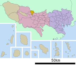

 Mizuho
Coordinates: 35°46′19″N 139°21′14″E / 35.77194°N 139.35389°ECoordinates: 35°46′19″N 139°21′14″E / 35.77194°N 139.35389°E Country Japan Region Kantō Prefecture Tokyo District Nishitama Area - Total 16.83 km2 (6.5 sq mi) Population (September 2011) - Total 33,506 - Density 1,990.8/km2 (5,156.3/sq mi) Time zone Japan Standard Time (UTC+9) Website Town of Mizuho Mizuho (瑞穂町 Mizuho-machi) is a town in Nishitama District, Tokyo, Japan. It was established on November 10, 1940, resulting from the merger of four villages and acquired additional land in 1958.
As of 2006, the town has an estimated population of 34,778 and the density of 2066.43 persons per km². The total area is 16.83 km².
Its neighbors are
- on the east, Musashi Murayama, Tokyo and Tokorozawa, Saitama
- on the south, Fussa, Tokyo
- on the west, Ōme and Hamura, Tokyo
- on the north, Iruma, Saitama
Contents
Education
Mizuho operates public elementary and junior high schools.
Tokyo Metropolitan Government Board of Education operates Mizuho Nōgei High School.
Sister city
See also
References
External links
 Media related to Mizuho, Tokyo at Wikimedia Commons
- Mizuho official website (Japanese)
Tokyo Metropolis Architecture · Education · Festivals · History · Politics · Sports · Tourism · Transportation Special Wards 

Cities Districts and
SubprefecturesPortal · Category Categories:- Towns in Tokyo
- Western Tokyo
- Tokyo geography stubs


Wikimedia Foundation. 2010.