- Coffee County, Tennessee
-
Coffee County, Tennessee 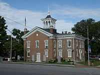 Coffee County courthouse in Manchester, Tennessee
Location in the state of Tennessee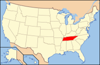
Tennessee's location in the U.S.Founded January 8, 1836 Seat Manchester Largest city Tullahoma Area
- Total
- Land
- Water
434 sq mi (1,125 km²)
429 sq mi (1,111 km²)
6 sq mi (15 km²), 1.29%Population
- (2010)
- Density
52,796
112/sq mi (43/km²)Time zone Central: UTC-6/-5 Coffee County is a county located in south-central portion of the U.S. state of Tennessee. It is one of the counties of Middle Tennessee. As of 2010, the population was 52,796. Its county seat is Manchester.[1]
Coffee County is part of the Tullahoma, Tennessee, Micropolitan Statistical Area.
Contents
Geography
According to the U.S. Census Bureau, the county has a total area of 434 square miles (1,124.1 km2), of which 429 square miles (1,111.1 km2) is land and 6 square miles (15.5 km2) (1.29%) is water.[2]
Adjacent counties
- Cannon County (north)
- Warren County (northeast)
- Grundy County (east)
- Franklin County (south)
- Moore County (southwest)
- Bedford County (west)
- Rutherford County (northwest)
Major highways
Demographics

As of the census[4] of 2000, there were 48,014 people, 18,885 households, and 13,597 families residing in the county. The population density was 112 people per square mile (43/km²). There were 20,746 housing units at an average density of 48 per square mile (19/km²). The racial makeup of the county was 93.43% White, 3.59% Black or African American, 0.30% Native American, 0.74% Asian, 0.03% Pacific Islander, 0.91% from other races, and 1.00% from two or more races. 2.19% of the population were Hispanic or Latino of any race.
There were 18,885 households out of which 32.40% had children under the age of 18 living with them, 56.90% were married couples living together, 11.10% had a female householder with no husband present, and 28.00% were non-families. 24.30% of all households were made up of individuals and 10.30% had someone living alone who was 65 years of age or older. The average household size was 2.50 and the average family size was 2.96.
In the county, the population was spread out with 25.10% under the age of 18, 8.30% from 18 to 24, 28.40% from 25 to 44, 23.60% from 45 to 64, and 14.60% who were 65 years of age or older. The median age was 38 years. For every 100 females there were 95.10 males. For every 100 females age 18 and over, there were 92.30 males.
The median income for a household in the county was $34,898, and the median income for a family was $40,228. Males had a median income of $32,732 versus $21,014 for females. The per capita income for the county was $18,137. About 10.90% of families and 14.30% of the population were below the poverty line, including 17.80% of those under age 18 and 15.20% of those age 65 or over.
American Indian Tribe
The Chikamaka Band is not state recognized. The Chikamaka Band maintain their Headquarters in Tracy City. The majority of members of the Tribe in Tennessee are located here and in the counties Coffee, Franklin, Marion, Sequatchie and Warren.
History
Carroll Van West of Middle Tennessee State University has written an excellent history of Coffee County:
"The Tennessee General Assembly established Coffee County from parts of Bedford, Warren, and Franklin Counties in 1836. It named the new county in honor of General John Coffee, a close political ally of Andrew Jackson. The county has several important prehistoric sites, the most significant being Old Stone Fort State Archaeological Area at the forks of the Duck River. Woodland Period people constructed a large ceremonial enclosure there. Carbon-dating within the walls has identified construction dates of A.D. 30, A.D. 230, and A.D. 430, indicating that the site was used for at least four centuries. Whites began to arrive in the county during the 1790s. Fort Nash, which protected travelers and encouraged permanent settlement, was established in 1793 on Garrison Fork near Beech Grove.
When the county was created in 1836, Manchester was named county seat on two hundred acres belonging to James Evans and Andrew Haynes. The first courthouse opened in 1837 and served the county until it burned and was replaced by the present Coffee County Courthouse in 1871. This Italianate-style courthouse is listed in the National Register of Historic Places.
The construction of the Nashville and Chattanooga Railroad during the 1850s reshaped the county's landscape and economy. Railroad officials created the town of Tullahoma as the mid-point of the railroad's line and established extensive works there, including a spur line from Tullahoma to Manchester to McMinnville, which eventually continued to coal mines and timber holdings in White County. The presence of the railroad brought both armies to Coffee County during the Civil War. Due to its importance as a rail center, both sides occupied Tullahoma at different times, destroying much of the original town. In August 1862 the Confederate cavalry of Nathan B. Forrest suffered 180 casualties in its attempt to destroy a Federal post protecting the railroad at Guest Hollow. The Tullahoma Campaign of 1863 touched many families and several county villages. At Beech Grove, for instance, a cemetery holds the remains of Confederate soldiers who died during the defense of Hoover's Gap.
A quickly rebuilt railroad returned prosperity in the Reconstruction era. Tullahoma grew rapidly into Coffee County's largest and most prosperous town. Important businesses included the retail firm of Dunn and Campbell, headed by Michael Ross Campbell; the Hurricane Springs resort six miles south of Tullahoma; the Tullahoma Woolen Mill; and the M. R. Campbell Hub, Spoke Rim, and Handle Works. Manchester added the Hickerson and Wooten Paper Company in 1879. The county's distillery business thrived in these decades, led by Maclin H. Davis's Cascade Distillery, founded in 1882 and now known as George Dickell Distilleries, which opened in 1959.
Transportation remained crucial to Coffee County's growth in the twentieth century. Tullahoma became a railroad division headquarters in 1920. Automobile traffic became increasingly important once the Dixie Highway located through the county, largely running parallel with the railroad tracks, during the 1920s. The prospect of good transportation attracted businesses such as the Lannom Manufacturing Company, which after 1922 made baseballs, softballs, and gloves. Coffee County emerged as a national leader in the sporting goods industry, led now by the Worth manufacturing corporation.
County leaders and civic officials in Tullahoma used the existing transportation network and the offer of free railroad land to convince government officials to locate a military base within the county. In 1926 the state established Camp Peay, a training facility for the National Guard, near Tullahoma. The surrounding countryside became the site of the guard's annual maneuvers and exercises.
The Great Depression slowed growth. The Works Progress Administration built a Colonial Revival-style post office in Manchester. In 1934 investors established in Tullahoma a clothing and shoe company called the General Shoe Corporation, the precursor of the major American corporation known today as Genesco.
World War II boosted the county as had no other event before. In January 1941 the general assembly created the volunteer Tennessee State Guard, which received federal training at Camp Peay. That June the U.S. Second Army came to Coffee County for maneuvers; headquarters were established at the high school in Manchester. The Second Armored Division under the command of Major General George S. Patton used the Coffee County terrain along the river to demonstrate the value, speed, and maneuverability of armored forces in a large-scale combat operation. After the attack on Pearl Harbor on December 7, 1941, government officials convinced the army to take control of Camp Peay and turn it into a federal induction center, renamed Camp Forrest. During the war, an estimated 250,000 soldiers passed through the gates of Camp Forrest, stimulating a commercial boom countywide but especially in Tullahoma. One estimate has the town's temporary population, counting service personnel, reaching 75,000 during the war years.
After Camp Forrest closed in 1946, local and state officials urged the federal government to transform the old military base into a modern technological and research center. On June 25, 1951, President Harry S. Truman formally dedicated the Arnold Engineering Development Corporation Center (AEDC), named in honor of General "Hap" Arnold, who commanded the Army Air Forces during World War II. AEDC ever since has been an important employer as well as an attraction for other high-tech personnel and firms to locate in the area. In the late twentieth century, Motlow State Community College and the Tullahoma Fine Arts Center have emerged as key institutions shaping modern cultural life in Coffee County. According to the 2000 census, 48,014 people lived in Coffee County, representing a 19 percent population growth since 1990."[5]
Coffee County has nine Century Farms.[1] The oldest Century Farm is Shamrock Acres, founded in 1818. Other Century Farms include:
- Beckman Farm
- Brown Dairy Farm
- Carden Ranch
- Crouch-Ramsey Farm
- The Homestead Farm
- Jacobs Farm
- Long Farm
- Thomas Farm
Events
The Bonnaroo Music Festival has been held annually in the county since 2002. [2] It has been well received by the locals who tend to overlook the extreme traffic problems it brings. It also appears to have been happily embraced by the county authorities as a source of tourist revenue.
The Bonnaroo Music Festival has actually been well-received by the Coffee County community, despite a smattering of negative press - mainly originating from regional, not local newspapers. The community expects to welcome the festival back for years to come, as evidenced by the fact that in 2007, the organizers of Bonnaroo (Superfly Productions and AC Entertainment) purchased 530 acres (2.1 km2) of the farm where the event takes place.
Cities and towns
- Hillsboro
- Manchester
- Noah
- Tullahoma
Points of interest
- Arnold Engineering Development Center
- George Dickel Tennessee whiskey distillery
- Old Stone Fort — part of Old Stone Fort State Archaeological Park, just west of Manchester
- Short Springs State Natural Area [3]
- Farrar Distillery – on the U.S. National Register of Historic Places
References
- ^ "Find a County". National Association of Counties. http://www.naco.org/Counties/Pages/FindACounty.aspx. Retrieved 2011-06-07.
- ^ "US Gazetteer files: 2010, 2000, and 1990". United States Census Bureau. 2011-02-12. http://www.census.gov/geo/www/gazetteer/gazette.html. Retrieved 2011-04-23.
- ^ Based on 2000 census data
- ^ "American FactFinder". United States Census Bureau. http://factfinder.census.gov. Retrieved 2008-01-31.
- ^ From The Tennessee Encyclopedia of History and Culture
External links
- Coffee County in the Tennessee Encyclopedia of History and Culture
- Coffee County at the Open Directory Project
- Bonnaroo Music Festival site
- http://thesaturdayindependent.com
Coordinates: 35°29′N 86°04′W / 35.49°N 86.07°W

Rutherford County Cannon County Warren County Bedford County 
Grundy County  Coffee County, Tennessee

Moore County Franklin County Municipalities and communities of Coffee County, Tennessee Cities 
CDPs Hillsboro | Lakewood Park | New Union
Unincorporated
communitiesBeech Grove | Noah
Footnotes ‡This populated place also has portions in an adjacent county or counties
Categories:- Tennessee counties
- 1836 establishments in the United States
- Populated places established in 1836
- Coffee County, Tennessee
- Tullahoma micropolitan area


Wikimedia Foundation. 2010.