- Mexborough
-
Coordinates: 53°29′57″N 1°16′59″W / 53.4992°N 1.2830°W
Mexborough 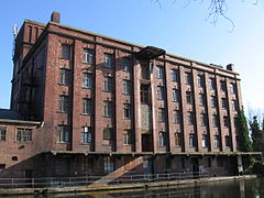
BBCS Warehouse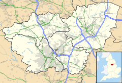
 Mexborough
Mexborough shown within South YorkshirePopulation 14,750 OS grid reference SE475005 Metropolitan borough Doncaster Metropolitan county South Yorkshire Region Yorkshire and the Humber Country England Sovereign state United Kingdom Post town MEXBOROUGH Postcode district S64 Dialling code 01709 Police South Yorkshire Fire South Yorkshire Ambulance Yorkshire EU Parliament Yorkshire and the Humber UK Parliament Doncaster North List of places: UK • England • Yorkshire Mexborough is a town in the metropolitan borough of Doncaster, South Yorkshire, England, situated on the north bank of the River Don west of its confluence with the River Dearne. It has a population of 14,750.[1]
Contents
History
The name Mexborough combines the Old English suffix burh meaning a fortified place with an Old English or Old Norse personal name, which may be Meke, Muik, Meoc, or Mjukr.[2][3]
Mexborough is located at the north eastern end of a dyke known as the Roman Ridge that is thought to have been constructed either by the Brigantian tribes in the 1st century AD,[4] perhaps as a defence against the Roman invasion of Britain, or after the 5th century to defend the British kingdom of Elmet from the Angles.[5]
The earliest known written reference to Mexborough is found in the Domesday Book of 1086 (Mechesburg), which states that prior to the Norman conquest of England the area had been controlled by the Saxon lords Wulfheah and Ulfkil.[6] Following the conquest the area fell under the control of the Norman Baron Roger de Busli. The remains of an earthwork in Castle Park are thought to have been a motte and bailey castle constructed in the 11th century shortly after the conquest.[7]
With the exception of St. John’s the Baptist C of E church, which includes elements that date from the 12th century,[8] most of the buildings in the town are post-1800. A few pre-1800 buildings remain, including several public houses; the Ferryboat Inn, the George and Dragon, the Bull’s Head and the Red Lion.
Throughout the 18th, 19th and much of the 20th centuries the town’s economy was based around coal mining, quarrying, brickworks and the production of ceramics, and it soon became a busy railway junction. These industries lead to an increase in industrial illness and an increase in the mortality rate. Although the town boasted a cottage hospital, the lack of suitable facilities led to Lord Montagu donating land for a new hospital to be built. Lord Montagu laid the first stone at the site in 1904. The site is still a working hospital, and now forms part of the Doncaster and Bassetlaw NHS trust.
The industries which led to the creation of Montagu hospital did not only bring problems to the town, they also led to an increase in population and, for some, an increase in wealth and opportunity. Many more public houses and other businesses were created, many of which are still trading today. It was in one of these public houses, the Montagu Arms, that Stan Laurel stayed overnight after performing at the town’s Prince of Wales theatre on 9 December 1907.
Following the demise of the coal mining industry in the 1980s Mexborough, like many ex-mining towns and villages, is still in the process of economic and social recovery.
The history of the town is chartered on the Mexborough & District Heritage Society's extensive website: [1]
Politics
Before 2010 Mexborough was in the Barnsley East and Mexborough constituency. Since then it has been in the Doncaster North constituency, whose current MP is Ed Miliband, Leader of the Labour Party.
Transport
The town is served by Mexborough railway station for trains going towards Doncaster and Sheffield. Mexborough also has a bus station.
Notable people
- Keith Barron – actor
- Brian Blessed – actor
- Dan Clarke – motor-racing driver formerly driving for Minardi Team USA in the Champ Car World Series
- Albert Fox – trade unionist
- William 'Iron' Hague – British heavyweight boxing champion 1908–1911
- Kenneth Haigh – actor
- Mike Hawthorn – motor-racing driver and 1958 Formula 1 World Champion
- Ted Hughes – Poet Laureate, 1984–1998
- Harold Massingham – poet
- Graham Oliver – guitarist and founder member of heavy metal band Saxon
- Ian Parks – poet
- Dennis Priestley – professional darts player, twice world darts champion 1991 and 1994
- John William Wall (pen name Sarban) – author whose works include the novel The Sound of His Horn and the collection Ringstones
- Donald Watson – founder of the Vegan Society
References
- ^ Office for National Statistics : Census 2001 : Urban Areas : Table KS01 : Usual Resident Population Retrieved 2009-08-26
- ^ Goodall, Armitage C. (1913). "Masborough, Mexborough". Place-Names of South-West Yorkshire; that is, of so much of the West Riding as lies south of the Aire from Keighley onwards. Cambridge: University Press. p. 209.
- ^ "Mexborough". A Key to English Place-Names. Institute for Name-Studies. http://www.nottingham.ac.uk/english/ins/kepn/. Retrieved 23 November 2008.
- ^ Boldrini, Nicholas (1999). "Creating space: a re-examination of the Roman Ridge". Transactions of the Hunter Archaeological Society 20: 24–30. ISSN 09662251.
- ^ Armitage, Ella Sophia (1905). "Chapter III: Camps and Earthworks". A key to English antiquities : with special reference to the Sheffield and Rotherham District. London: J.M. Dent. http://www.archive.org/details/keytoenglishanti00armiuoft.
- ^ Williams, Ann; Martin, G.H. (eds) (1992). Domesday Book, a Complete Translation. London: Penguin Books Ltd.. p. 828. ISBN 0141439947.
- ^ Armitage, Ella Sophia (1905). "Chapter V: Moated Hillocks". A key to English antiquities : with special reference to the Sheffield and Rotherham District. London: J.M. Dent. http://www.archive.org/details/keytoenglishanti00armiuoft.
- ^ "Church of St. John the Baptist". Images of England. English Heritage. http://www.imagesofengland.org.uk/details/default.aspx?id=334556. Retrieved 23 November 2008.
Ceremonial county of South Yorkshire Metropolitan districts Major settlements Askern • Barnsley • Bawtry • Brierley • Conisbrough • Dinnington • Doncaster • Edlington • Hatfield • Hoyland • Maltby • Mexborough • Penistone • Rotherham • Sheffield • South Kirkby and Moorthorpe • Stainforth • Stocksbridge • Swinton • Thorne • Tickhill • Wath upon Dearne • Wombwell
See also: List of civil parishes in South YorkshireRivers Topics Categories:- Villages in Doncaster
- Mexborough
- Towns in South Yorkshire


Wikimedia Foundation. 2010.