- Dinnington
-
Coordinates: 53°22′00″N 1°12′00″W / 53.3667°N 1.200°W
Dinnington
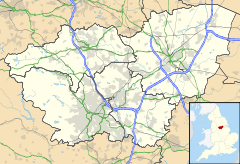
 Dinnington shown within South Yorkshire
Population 9,161 (2001) OS grid reference SK5386 Parish Dinnington St John's Metropolitan borough Rotherham Metropolitan county South Yorkshire Region Yorkshire and the Humber Country England Sovereign state United Kingdom Post town SHEFFIELD Postcode district S25 Dialling code 01909 Police South Yorkshire Fire South Yorkshire Ambulance Yorkshire EU Parliament Yorkshire and the Humber UK Parliament Rother Valley List of places: UK • England • Yorkshire Dinnington is a town in rural South Yorkshire, England, and part of the Metropolitan Borough of Rotherham. It is roughly equidistant from Sheffield, Rotherham and Worksop, and is located at an elevation of about 100 metres above sea level.
Dinnington is the principal settlement in the civil parish of Dinnington St John's, which also includes the small satellite hamlets of Throapham and St John's. The Dinnington St John's parish is the most populous constituent of the St John's ward, which also includes the parishes of Laughton-en-le-Morthen, Firbeck, Letwell and Gildingwells. In 2001, this ward had a population of 11,476, with Dinnington St John's itself making up 9,161 of that figure.[1]
Excavations show Dinnington to have been inhabited since at least Neolithic times, and it has been suggested that the settlement takes its name from a local barrow, though a more traditional interpretation of "Dinnington" would be "Dunn's Farmstead".
Dinnington was originally a small, isolated farming community, based around the New Road area of the town. Quarrying in the area helped expand the population, but it was the sinking of the Dinnington Main Colliery in 1905 that led to the real growth of the settlement. The census of 1911 shows a twenty-fold increase in population since 1901, from 250 to 5000.
The coal miners initially lived in a prefabricated shanty town in Laughton Common but later moved into Colliery-built terrace houses around the central shopping area of Laughton Road.
Dinnington continued to expand throughout the 20th century, largely through the growth of commuter living that followed the Second World War. As the housing estates spread, Dinnington began to merge seamlessly into the neighbouring settlements of Throapham and North Anston. The result is a 3.5 km strip of urban development that mainly acts as a commuter base for Sheffield, Rotherham and Worksop.
In 1992, Dinnington Colliery was closed with a loss of 1000 jobs, devastating the local community. A business park on the colliery site, and small-scale commercial redevelopment has gone some way towards a recovery.
Dinnington has two further education establishments in the form of Rotherham College of Arts and Technology and the sixth form college at Dinnington Comprehensive School. There is a Tesco around the main shopping area on Laughton Road near the library.[2]
In 2003, Dinnington declared itself a town in an attempt to attract more investment and improve the local economy. The Manor Motorsport team (called Virgin Racing in Formula One) is also based in Dinnington.
Recent controversy has arisen in the village surrounding plans to redevelop the Miners Welfare. The Welfare buildings and sports fields were provided originally for the miners at the local colliery by CISWO in 1926. The proport has been latterly leased to Rotheham Borough Council and was used for Safe@Start programmes up until 2007. It has remained empty since that date and has been subject to vandalism and lack of repairs. The controversy regarding development has resulted in the formation of a local residents group opposing the development plans and asking for the regeneration of the site as an amenity for local people. [3]
See also
References
- ^ Office for National Statistics : Census 2001 : Parish Headcounts : Rotherham Retrieved 2009-08-28
- ^ Dinnington Community Library
- ^ Dinnington Today "Dinnington welfare means so much to so many" Retrieved 2011-03-01
External links
- Dinnington Guardian newspaper
- Dinnington Town FC
- Dinnington Rugby Club
- Local news
- Rotherham Web
- St Leonard's church
- Dinnington Youth Theatre
Ceremonial county of South Yorkshire Yorkshire Portal Metropolitan districts Major settlements Askern • Barnsley • Bawtry • Brierley • Conisbrough • Dinnington • Doncaster • Edlington • Hatfield • Hoyland • Maltby • Mexborough • Penistone • Rotherham • Sheffield • South Kirkby and Moorthorpe • Stainforth • Stocksbridge • Swinton • Thorne • Tickhill • Wath upon Dearne • Wombwell
See also: List of civil parishes in South YorkshireRivers Topics Categories:- Dinnington
- Towns in South Yorkshire
- Geography of Rotherham
Wikimedia Foundation. 2010.

