- Chitalmari Upazila
-
Chitalmari
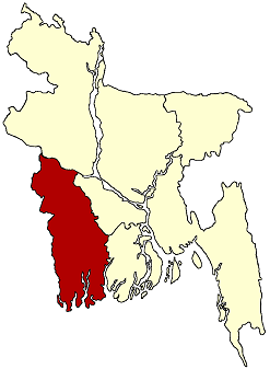
চিতলমারি— Upazila — Location in Bangladesh
 Chitalmari
Coordinates: 22°47.5′N 89°52.7′E / 22.7917°N 89.8783°ECoordinates: 22°47.5′N 89°52.7′E / 22.7917°N 89.8783°E Country  Bangladesh
Division Khulna Division District Bagerhat District Area - Total 192 km2 (74.1 sq mi) Population (1991) - Total 127,524 - Density 664/km2 (1,719.8/sq mi) Time zone BST (UTC+6) GPO 9360 Website https://sites.google.com/site/chitalmari/home Chitalmari (Bengali: চিতলমারি) is an upazila of Bagerhat District in the Khulna Division, Bangladesh.
Contents
Geography
Chitalmari is located at 22°46′51″N 89°52′26″E / 22.78071°N 89.87390°E. It has 24,306 households and a total area of 192 km². Chitalmari Upazila is bounded by Tungipara Upazila on the north, Kachua Upazila and Bagerhat Sadar Upazila on the south, Nazirpur Upazila on the east, and Mollahat Upazila and Fakirhat Upazila on the west. Lakkhanar Beel, Kalshirar Beel and Ruiar Beel are notable. The main rivers are the Madhumati, Kaliganga, Chitra, and Baleshwar rivers.
Demographics
As of the 1991 Bangladesh census, Chitalmari has a population of 127,524. Males constitute 50.78% of the population, and females 49.22%. This Upazila's eighteen-and-up population is 65,065. Chitalmari has an average literacy rate of 37% (7+ years), and the national average is 32.4% literate.[1] Chitalmari's religious composition is 60.45% Muslim, 39.35% Hindu, and 2% others. Religious institutions include 184 mosques, 72 temples, and one church. Notable sacred places are Central Jami Mosque, Durgapur Temple and Boalia Durga Mandir.
Chitalmari (Town) consists of 2 mouzas with an area of 0.89 km². It has a population of 973; male 53.55%, female 46.45%. The literacy rate among the town's people is 52.5%.
Chitalmari thana was turned into an upazila in 1983. Chitalmari has 7 unions/wards, 58 mouzas/mahallas, and 121 villages.
Economy
The main occupations can be categorized thus: 52.77% agriculture, 1.35% fishing, 24.11% agricultural labourer, 1.72% non-agricultural labourer, 8.49% commerce, 5.18% service, and 6.38% others. There are 15,584 hectares of arable land (0.11 hectares of arable land per head) and 3206 hectares of fallow land. The average market value of first-grade land is Tk. 5000 per 0.01 hectare. 89% of the land is under irrigation. Among the peasants, 40% are landless, 29% own a small amount of land, 18% are classified as intermediate and 13% are rich. The main crops are paddy, wheat, jute, pulse, onion, chalkumra and potato. Extinct and nearly extinct crops include tobacco, spices, jute, and aman paddy. Fruits produced include the mango, blackberry, banana, coconut and betel nut. Roads: pucca 15 km, semi pucca 20 km and mud roads 432 km. There are 8 flour mills, 2 chira mills, 4 ice factories, and 127 rice mills. Major cottage industries include bamboo work, tailoring, wood work, weaving, goldsmith, blacksmith and welding. Notable fairs and markets include Shailadha Bazaar, Khager Hat and Chardakatia Baruni Mela. Chief exports include leather, paddy, banana, coconut, betel nut and vegetables.
Facilities and infrastructure
There are many private hospitals and one 50-bed hospital. Educational institutions include 2 colleges (Sher-E-Bangla Degree College and Bangobindhu Women’s College), 26 high schools, 14 madrasas, 63 government primary schools and 45 non-government primary schools. Many high-ranking government officials have come from Chitalmari Upazila.
There is one public library, one cinema hall, 2 theatre groups, 123 rural clubs and 30 playgrounds.
The local newspaper is Namos Dut, edited and published by Bivash Das.
During the war of liberation, the Pakistan Army, in collaboration with local razakars, conducted mass killings at Khalishakhali and Babuganj Bazaars. They killed about 200 villagers. The event is commemorated by a monument at Santuspur.
References
- ^ "Population Census Wing, BBS.". Archived from the original on 2005-03-27. http://web.archive.org/web/20050327072826/http://www.bangladeshgov.org/mop/ndb/arpc91_v1/tables04.htm. Retrieved November 10, 2006.
Categories:- Upazilas of Bagerhat District

Wikimedia Foundation. 2010.