- Nazirpur Upazila
-
Nazirpur
নাজিরপুর— Upazila — Location in Bangladesh
 Nazirpur
Coordinates: 22°44.8′N 89°58.1′E / 22.7467°N 89.9683°ECoordinates: 22°44.8′N 89°58.1′E / 22.7467°N 89.9683°E Country  Bangladesh
Division Barisal Division District Pirojpur District Area – Total 233.65 km2 (90.2 sq mi) Population (1991) – Total 166,014 – Density 711/km2 (1,841.5/sq mi) Time zone BST (UTC+6) Website Official Map of the Nazirpur Upazila Nazirpur (Bengali: নাজিরপুর ) is an Upazila of Pirojpur District in the Division of Barisal, Bangladesh.
Contents
Geography
Nazirpur is located at 22°44′46″N 89°58′04″E / 22.7461°N 89.9678°E . It has 31862 units of house hold and total area 233.65 km².
Demographics
As of the 1991 Bangladesh census, Nazirpur has a population of 166014. Males constitute are 50.92% of the population, and females 49.08%. This Upazila's eighteen up population is 86581. Nazirpur has an average literacy rate of 43.4% (7+ years), and the national average of 32.4% literate.[1]
Administrative
Nazirpur has 8 Unions/Wards, 69 Mauzas/Mahallas, and 142 villages.
See also
References
- ^ "Population Census Wing, BBS.". Archived from the original on 2005-03-27. http://web.archive.org/web/20050327072826/http://www.bangladeshgov.org/mop/ndb/arpc91_v1/tables04.htm. Retrieved November 10, 2006.
 Upazilas of the Barisal DivisionCapital: Barisal
Barguna District 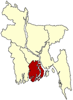
Barisal District Agailjhara · Babuganj · Bakerganj · Banaripara · Gaurnadi · Hizla · Barisal · Mehendiganj · Muladi · WazirpurBhola District Jhalokati District Patuakhali District Pirojpur District Categories:- Upazilas of Pirojpur District
- Barisal Division geography stubs

Wikimedia Foundation. 2010.