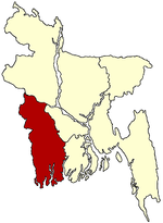
- Chaugachha Upazila
-
Chowgacha
চৌগাছা— Upazila — Location in Bangladesh Coordinates: 23°16′N 89°1.5′E / 23.267°N 89.025°ECoordinates: 23°16′N 89°1.5′E / 23.267°N 89.025°E Country  Bangladesh
Division Khulna Division District Jessore District Area - Total 268.89 km2 (103.8 sq mi) Population (1991) - Total 181,829 - Density 676/km2 (1,750.8/sq mi) Time zone BST (UTC+6) Website Official Map of Chaugachha Chowgacha (Bengali: চৌগাছা) is an Upazila of Jessore District in the Division of Khulna, Bangladesh.
Contents
Geography
Chowgacha is located at 23°16′00″N 89°01′30″E / 23.2667°N 89.0250°E . It has 33765 units of house hold and total area 268.89 km².
Demographics
As of the 1991 Bangladesh census, Chowgacha has a population of 181829. Males constitute are 51.6% of the population, and females 48.4%. This Upazila's eighteen up population is 91297. Chaugachha has an average literacy rate of 25.5% (7+ years), and the national average of 32.4% literate.[1]
Administrative
Chowgacha has 11 Unions/Wards, 149 Mauzas/Mahallas, and 166 villages.
History
There is an long history behind Chowgacha. It is named after the four banyan tree beside the Chowgacha.
Historical Places
Nilkuthi, Muktinagar, Bergobindopur baor.
See also
References
- ^ "Population Census Wing, BBS.". Archived from the original on 2005-03-27. http://web.archive.org/web/20050327072826/http://www.bangladeshgov.org/mop/ndb/arpc91_v1/tables04.htm. Retrieved November 10, 2006.
Categories:- Upazilas of Jessore District
- Khulna Division geography stubs
Wikimedia Foundation. 2010.


