- Indian Island (Humboldt Bay)
-
Gunther Island Site 67
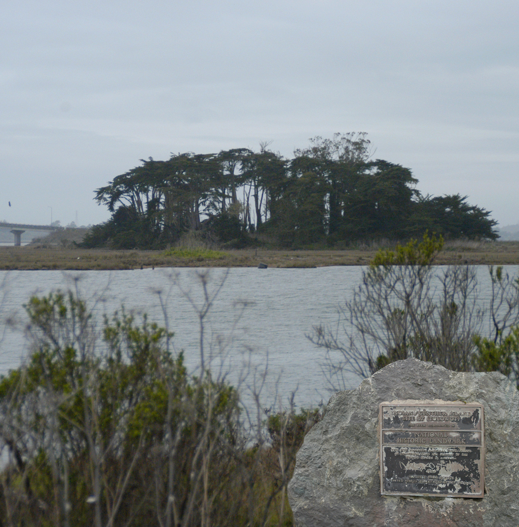
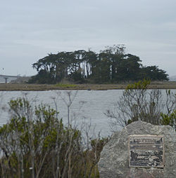 National Register of Historic Places marker on Woodley Island in foreground, Indian Island on other side of channel.

Location: Address restricted Nearest city: Eureka, California Coordinates: 40°48′46.46″N 124°10′6.22″W / 40.8129056°N 124.1683944°WCoordinates: 40°48′46.46″N 124°10′6.22″W / 40.8129056°N 124.1683944°W Area: 6 acres (24,000 m2)[2] Governing body: Local NRHP Reference#: 66000208[1] Significant dates Added to NRHP: October 15, 1966 Designated NHL: July 19, 1964[3] Indian Island or Duluwat Island is located on Humboldt Bay within the City of Eureka, California. The village of Tolowot or Tuluwat on Duluwat Island was the site of the spiritual if not political center of the Wiyot people and is where the main thrust of the 1860 Wiyot Massacre by European settlers took place. It has also been called Gunther Island, and is the site of a National Historic Landmark which encompasses the midden at Gunther Island Site 67.
Contents
Geography
The island is the largest of three islands located between the Samoa and Eureka Channels within Humboldt Bay and primarily consists of tidal marsh. Over time, human habitation on the island changed its topography, in part due to a process known as shell mounding, which increased the elevation of the island as Wiyot continually placed shells remaining from subsistence fishery management in the same location over a period of centuries.[4]
History
Early history
The indigenous Wiyot lived in Tolowot village on Duluwat Island long enough to alter the topography by the accumulation of shell fragments in middens, and the island became tall enough to be visible on the horizon from several miles away.[1]
A non-degree student and employee of the University of California Llewellyn Lemont Loud (1879-1946)[5] conducted archaeological excavations of the island in 1918 that showed evidence of habitation since around 900 AD. The group of artifacts he excavated and described became known as the Gunther Pattern or Gunther Phase[4] which encompasses the final phase of native dominance lasting until historic times and describes a style of Native American projectile points, grave goods and other archaeological remains which identify a second migration within California around 300 AD[6] The first major evidence of this came from Gunther Island Site 67 on Indian Island.[4]
1860 massacre
Main article: 1860 Wiyot MassacreOn February 26, 1860, about one hundred Wiyot men, women and children were massacred during a World Renewal Ceremony. The massacre was carried out by European immigrants who had settled in the area since 1850 as part of the California Gold Rush. There were few survivors.[7]
European settlement
Robert Gunther acquired the island in 1860, the same year of the massacre, giving it the name it had for much of recent history. Gunther diked the island and ran dairy cattle there for nearly 40 years.[4]
In the 1870s a shipyard repair facility was constructed. The shipyard operated until the 1980s.[8]
Modern era
In 1971 Caltrans built a series of bridges (known collectively as the Samoa Bridge), which cross Humboldt Bay and now directly connect the City of Eureka with the peninsula. Two of these bridges have footings on Indian Island.
Every year since 1992, the Wiyot people and supporters come to the island on the last Saturday in February to heal the community, and remember the human lives lost at the time of the Massacre. Every year participation has increased at the vigil on a nearby island.
In June 2004, 67 acres (270,000 m2) of land was repatriated back into Wiyot hands. The City of Eureka, California transferred the area towards the Wiyot's goal to see the Wiyot dance the World Renewal ceremony again on the island.[8]
The City of Eureka and the Wiyot Tribe have installed temporary erosion control system to mitigate erosion on the site.[9] Contamination from the shipyard activities will need to be cleaned up prior to the development of a new Wiyot dance facility.[8]
References
- ^ a b National Register Information System (2008-04-15). "National Register of Historic Places". National Park Service. http://nrhp.focus.nps.gov/natreg/docs/All_Data.html. Retrieved 03 March 2011.
- ^ U.S. Geological Survey Geographic Names Information System: Indian Island (Humboldt Bay)
- ^ NHL Summary
- ^ a b c d Elsasser, Albert B. (1986). Symposium: A New Look at some Old Sites, Papers from the Symposium Organized by Francis A. Riddell: Annual Meeting of the Society for California Archaeology, March 23-26, 1983, San Diego, California.. 6. Coyote Press Archives of California Prehistory. pp. 49–54. 25 May 2011. http://www.californiaprehistory.com/reports01/rep0007.html.
- ^ Barker, Pat (4 January 2011). "L.L. Loud and the Beginning of Nevada Archaeology". Online Nevada Encyclopedia. http://www.onlinenevada.org/l.l._loud_and_the_beginning_of_nevada_archaeology. Retrieved 23 September 2011.
- ^ Martinek, Gary (May 25, 2005). "Coastal Healthy Forest Treatments Heritage Resources". Coastal Healthy Forest Treatments. http://www.fs.fed.us/r6/rogue-siskiyou/projects/planning/coast-health-forest-treat/05l-heritage.pdf. Retrieved 23 September 2011.
- ^ "The Humboldt Butchery of Indian Infants and Women-Jacob Elyea Hanged Bogus Mining Stories A Solid Ledge of Gold at Jacksonville Items About Town, & c.". New York Times. April 12, 1860. http://www.fs.fed.us/r6/rogue-siskiyou/projects/planning/coast-health-forest-treat/05l-heritage.pdf. Retrieved 23 September 2011.
- ^ a b c "Tuluwat Project". Wiyot Tribe. http://www.wiyot.com/tuluwat-project. Retrieved 23 September 2011.
- ^ "Tolowot, Gunther Island Site 67". National Historic Landmarks Program. National Park Service. http://tps.cr.nps.gov/nhl/detail.cfm?ResourceId=114&ResourceType=Site. Retrieved 23 September 2011.
External links
Additional references
- Heizer, R.F.; A.B. Elsasser (1964). The Archaeology of Hum-67: The Gunther Island Site in Humboldt Bay, California. 62. Berkeley, CA: Reports of the University of California Archaeological Survey. pp. 390.
U.S. National Register of Historic Places Topics Lists by states Alabama • Alaska • Arizona • Arkansas • California • Colorado • Connecticut • Delaware • Florida • Georgia • Hawaii • Idaho • Illinois • Indiana • Iowa • Kansas • Kentucky • Louisiana • Maine • Maryland • Massachusetts • Michigan • Minnesota • Mississippi • Missouri • Montana • Nebraska • Nevada • New Hampshire • New Jersey • New Mexico • New York • North Carolina • North Dakota • Ohio • Oklahoma • Oregon • Pennsylvania • Rhode Island • South Carolina • South Dakota • Tennessee • Texas • Utah • Vermont • Virginia • Washington • West Virginia • Wisconsin • WyomingLists by territories Lists by associated states Other Categories:- Archaeology of the United States
- Eureka, California
- Landforms of Humboldt County, California
- Islands of California
- Wiyot people

Wikimedia Foundation. 2010.