- Majuli
-
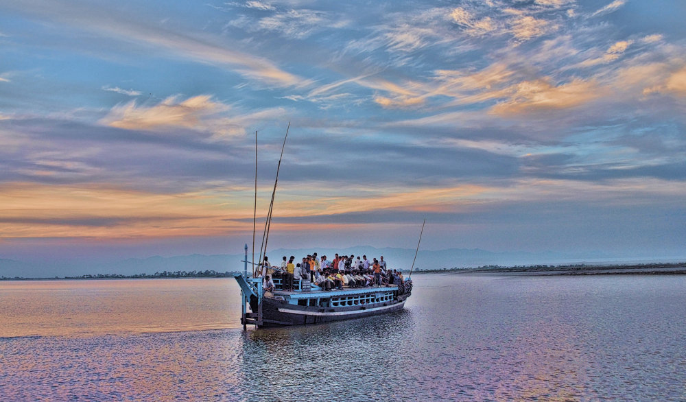
Majuli River Brahmaputra State Assam District Jorhat Location 27°N 94°E / 27°N 94°E Area 1,250 km2 (483 sq mi) (2001) Elevation 84.5 m Population 140,000 Website majuli.info  Way To Majuli From Jorhat City
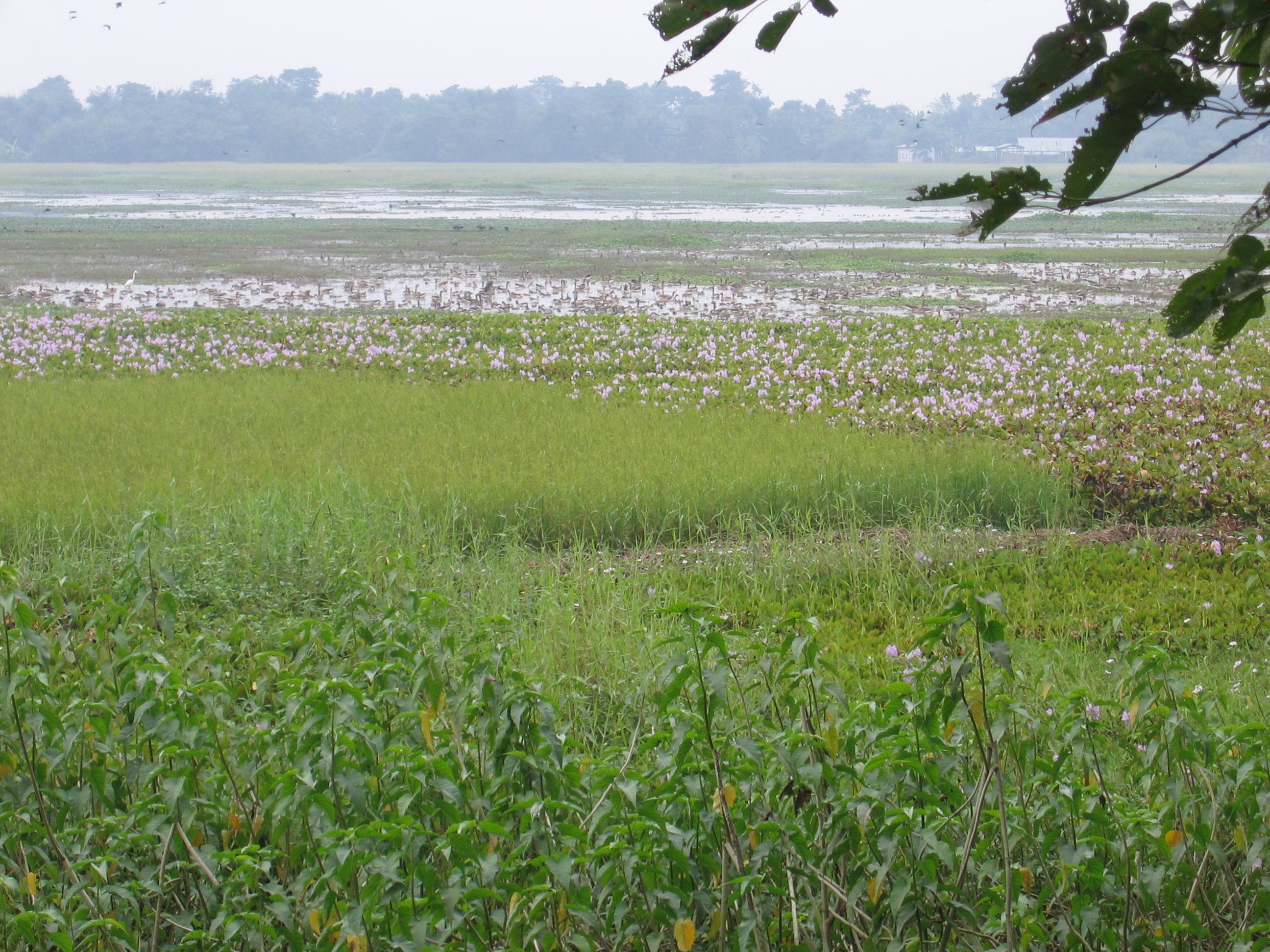
 One of the wetlands of Majuli
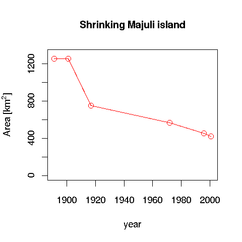
Majuli or Majoli (Assamese: মাজুলী) is a large river island in the Brahmaputra river, in the Indian state of Assam. Majuli had a total area of 1,250 square kilometres (483 sq mi), but having lost significantly to erosion it has an area of only 421.65 square kilometres (163 sq mi) in 2001.
The island is formed by the Brahmaputra river in the south and the Kherkutia Xuti, an anabranch of the Brahmaputra, joined by the Subansiri River in the north.Majuli island is accessible by ferries from the City of Jorhat.The island is about 200 kilometres east from the state's largest city — Guwahati. The island was formed due to course changes by the river Brahmaputra and its tributaries, mainly the Lohit. Majoli is also the abode of the Assamese neo-Vaisnavite culture.
Contents
History
Originally, the island was a narrow and long piece of land called Majoli (land in the middle of two parallel rivers) that had Brahmaputra flowing in the north and the Burhidihing flowing in the south, till they met at Lakhu. Frequent earthquakes in the period 1661–1696 set the stage for a catastrophic flood in 1750 that continued for 15 days, which is mentioned in historical texts and reflected in folklore. As a result of this flood, the Brahmaputra split into two anabranches—one flowing along the original channel and the other flowing along the Burhidihing channel and the Majuli island was formed. The Burhidihing's point of confluence moved 190 km east and the southern channel which was the Burhidihing became the Burhi Xuti. The northern channel, which was previously the Brahmaputra, became the Luit Xuti. In due course, the flow in the Luit Xuti decreased, and it came to be known as the Kherkutia Xuti; and the Burhi Xuti expanded via erosion to become the main Brahmaputra river (Sarma 2004, p. 6).
Krishna, the popular Hindu god is supposed to have played here with his friends. While this is speculative, the locals speak in the Assamese language. However, what is certain is Majuli has been the cultural capital of Assamese civilisation since the 16th century; based on written records describing the visit of Sankardeva — a 16th century social reformer. Sankardeva, a pioneer of the medieval-age neo-vaishnavite movement, preached a monotheist form of Hinduism called as Vaishnavism and established monasteries and hermitages known as satras on the islet.
The island soon became the leading centre of Vaishavinism with the establishment of these satras. After the arrival of the British, the island was under the rule of the British till India gained independence in 1947.
Economy
The main industry is agriculture, with paddy being the chief crop. Majuli has a rich and diverse agricultural tradition, with as many as a hundred different varieties of rice grown, all grown without pesticides or artificial fertilisers. Among the fascinating arrays of rice produced are the Komal Saul, a unique type of rice that can be eaten just after immersing the grains in warm water for fifteen minutes, and usually eaten as a breakfast cereal; the bao dhan, that grows under water, and is harvested after ten months and the Bora saul, a sticky brown rice used to make the traditional cake known as pitha,. Fishing, dairying, pottery, handloom and boat-making are other important economic activities.
Handloom is a major occupation among the distaff population of the villages. Although largely a non-commercial occupation, it keeps many of the inhabitants occupied. Weaving is exquisite and intricate with the use of a variety of colours and textures of cotton and silk, especially 'muga' silk..
People
The dwellers of Majuli are mostly tribal folk. These tribal are the mishing tribes from Arunachal Pradesh and who immigrated here centuries ago. Apart from them, the inhabitants are also from the Deori and Sonowal Kacharis tribes. Languages spoken here are Mishing, Assamese, Deori. The island has one hundred and forty four villages with a population of 150,000 and a density of 300 individuals per square km. The only mode of association to the outside world is through a ferry service which operates only twice a day. Despite inherent drawbacks faced, modernism has touched this island, with the setting up of medical centres and educational institutions. Housing too, has segued from traditional bamboo and mud construction to ones made of concrete.
The heart of all villages is the Namghar, where villagers episodically gather to sing and pray. It is the most important public place for the villagers. After the rituals are complete, villagers decide here on issues concerning the village such as auctioning of fishing rights, what to do with money raised, and other topics of significance to the community as a whole.
The inhabitants are expert navigators by boat; their expertise is most visible during the monsoon season when they navigate the turbulent waters of the Brahmaputra. Extremism is also a major concern in the region. The insurgent group the ULFA, has a wide network in the region and was responsible for the execution of social worker Sanjoy Ghosh who was trying to uplift the people of the island.
Culture
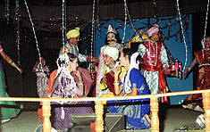 Raas Leela in Majuli
Majuli has been the cultural capital and the cradle of Assamese civilization for the past five hundred years. The satras set up preserve antiques like weapons, utensils, jewellery and other items of cultural significance. Pottery is made in Majuli from beaten clay and burnt in driftwood fired kilns in the same mode carried out by the peoples of the ancient Harrappan Civilisation. Sociologists have stressed on the preservation of these unique peoples, whose culture and dance forms are untouched by modernism. The handloom work of these tribes is also internationally famous.
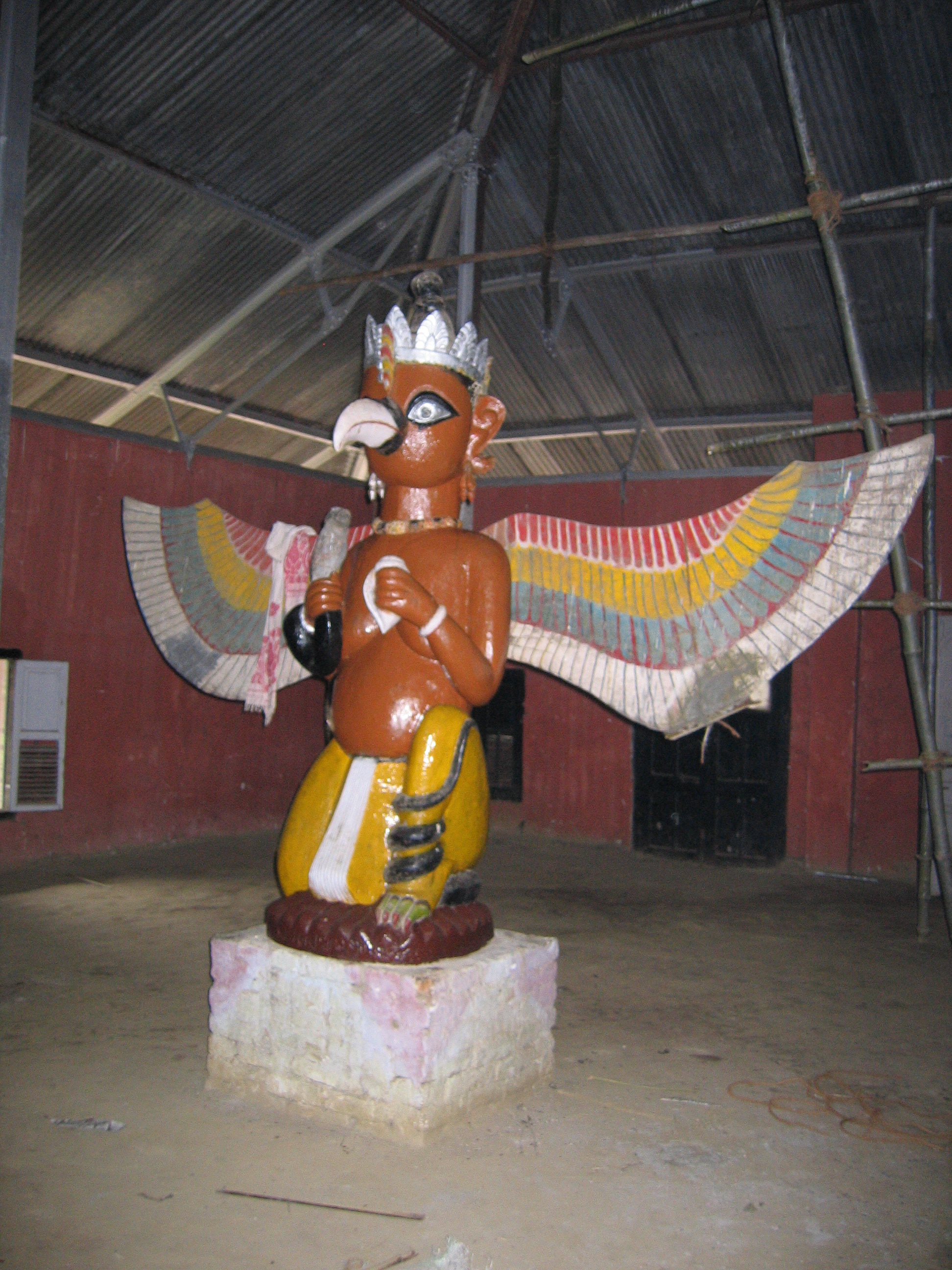
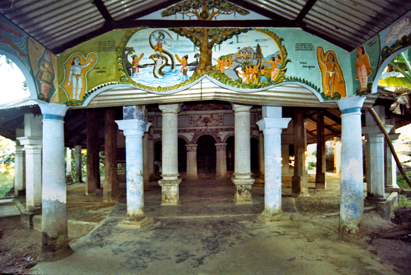
Virtually every single person on the island is involved in the three-day long raas festival, depicting the life of Krishna. People from hundreds of kilometres away come to celebrate this festival including a number of expatriate members of community. The satras have also honed certain art and craft traditions, which can now be found only here. In Natun Samuguri satra for example, one can still find the craft of mask-making; and in the Kamalabari satra the finest boats are made.
 From one of the satras
The island has been the hub of Assamese neo-Vaishnavite culture, initiated around 15th century by the revered Assamese saint Srimanta Sankardeva and his disciple Madhabdeva. Many Xatras or monasteries constructed by the saint still survive and represent the colourful Assamese culture. The saint took refuge in Majuli and spent a couple of months at Beloguri in West Majuli, which was a place of grandeur for the historic and auspicious, 'Manikanchan Sanjog' between Shankardeva and Madhavdeva, this was the first satra in Majuli. After the "Manikanchan Sanjog", sixty five satras were set up. However, today only twenty-two of the original sixty-five still survive. Sixty-five out of the six hundred and sixty-five original satras in Assam were situated in Majuli.
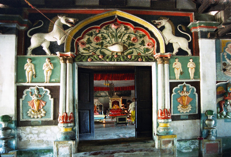
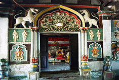 Dakhinpat Satra
The main surviving Xatras (Satra) are:
- Dakhinpat Xatra : Founded by Banamalidev, a supporter of Raasleela, which is now observed as one of the National Festivals of Assam.
- Garamurh Xatra : This "Satra" was founded by Lakshmikantadeva. During the end of autumn, the traditional the Raasleela is enacted with pomp and celebrations. Ancient weapons called "Bartop" or cannonss are preserved here.
- Auniati Xatra: Founded by Niranjan Pathakdeva, the satra is famous for the "Paalnaam" and Apsara Dances and also its extensive assortment of ancient Assamese artefacts, utensils, jewellery and handicrafts. It also has a hundred and twenty five disciples and over seven hundred thousand followers worldwide.
 Kamalabari Satra
- Kamalabari Xatra: The Kamalabari Satra, founded by Bedulapadma Ata, is a centre of art, cultural, literature and classical studies on the island. Its branch the Uttar Kamalabari Satra has performed cultural programmes of the Satria Art all around the country and abroad.
- Benegenaati Xatra: It is a reliquary of antiques of cultural importance and an advance centre of performing art. Muraridev, the grandson of Sankaradeva's stepmother was the founder of the Satra. The royal raiment belongs to the Ahom king Swargadeo Godadhar Singha, is made of gold. Also preserved is the royal umbrella made in gold.
- Shamaguri Xatra: The satra is famous for the masks making in India.
These satras are also the treasure house of "Borgeet" Matiakhara, satriya dances (Jumora Dance, Chali Dance, Notua Dance, Nande Vringee, Sutradhar, Ozapali, Apsara Dance, Satria Krishna Dance and Dasavater Dance), all promulgated by Srimanta Sankardeva. It has also become a center for shuddhi in the Northeast of India, due to the efforts of Pitambar Deva Goswami.
Ecosystem
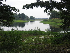 Majuli wetland
A wetland, Majuli is a hotspot for flora and fauna, harbouring many rare and endangered avifauna species including migratory birds that arrive in the winter season. Among the birds seen here are: the Greater Adjutant Stork , Pelican, Siberian Crane and the Whistling Teal. After dark wild geese and ducks fly in flocks to distant destinations. The island is almost pollution free owing to the lack of polluting industries and factories and also the chronic rainfall.
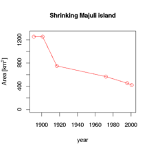 The island is shrinking due to erosion. The data is from (Sarma 2004).
The island is under threat due to the extensive soil erosion on its banks. The reason for this magnitude in erosion is the large embankments built in neighbouring towns upriver to prevent erosion there during the monsoon season when the river distends its banks. The upshot is a backlash of the tempestuous Brahmaputra's fury on the islet, eroding most of the area. According to reports, in 1853, the total area of Majuli was 1,150 km² and about 33% of this landmass has been eroded in the latter half of 20th century. Since 1991, over 35 villages have been washed away. Surveys show that in 15–20 years from now, Majuli would cease to exist.
To save the island, the Union Government of India has sanctioned Rs 250 crores (US $ 55 million) for the protection of the isle. A petition has been sent to the UNESCO for the declaration of Majuli to be a world natural heritage site and furthermore make it a world cultural heritage site.
Tourist interests
Majuli is situated at a distance of 20 km from Jorhat. One can take the bus or a hired taxi to the Nimati Steamer Ghat from where ferry services ply. The distance takes over three hours to cover, with three bus rides and two ferry rides.
On the north-bank is the river Subansiri and on the South bank, the mighty Brahmaputra has excided the island from the main land. Lakhimpur town is to the North and Golaghat is to its southwest. The town of Sibsagar is on the southeast and Jorhat is to the south. On the extreme east is Dibrugarh District.
- The Vaishnava Satras founded by Sankardeva
- The colourful culture of the tribes
- Migratory birds
- The Ali-ai-ligang festival in Feb-March
- Pottery making
- Mask making
- Paal Namm festival in the end of winter
- The sunset in winter
- Exotic homespun masks crafts
Educational Institute
Main article: List of educational institutes in MajuliColleges
- Majuli College
- Jengeraimukh College
- Ujoni Majuli Kherkotia Mahavidyalaya
- Rongasahi College
- Pub Majuli College
- Garamur college
Junior Colleges
- Namoni Majuli Junior College
- Pitambar Deva Goswami College
Schools
- Jengraimukh High School
- Jengraimuk Girl's High School
- St. Paul's School
- Sri Lohit High School
- Majuli Auniati Hem Chandra High School
- Meragarh Narayandev Higher Secondary School,situated Eatern part of Majuli near Bongan(small comercial place).This is one of the Best schoolin Majuli.Many of the alumini of the school achieved highest degree in Medicines andOther fields.
- Chamaguri Satra Rawanapar[CSR] Model Higher Secondary School[estd.1962]
- N. S. Greenwood English Medium High School
- Mekheligaon Janata Girls' High School
- Karatipar High School . easted 1940.
- Milonjyoti High School,Totoya Gaon
- Bapuji High school
- rangachahi t n high school
- Madhya Majuli Parijat Higher secondary School,Hazarika gaon.
- Jonaki Chamahiya Ati Higher Secondary School.
- Vivekananda Kendra Vidyalaya
- Phulani high school
- Phulani MEschool
- No 1 Phulani LP school
- Garamur sri sri pitambor dev high school
- Chiram High school
- Bhakatiduar Higher Secondary School
- Ratanpur Miri High School
- Chiram Banamalidev Higher Secondary School
- Mudoibil Teliabari Senior basic School
- Major Deori Tribal High School
Politics
Mr. Rajiv Lochan Pegu[2001-2006 & 2006-2011] is the current MLA(Member of legislative assembly) from Majuli in Assam Assembly. Majuli is part of Lakhimpur (Lok Sabha constituency) Mrs Rani Narah Is the MP (Cong-I).[1]
References
- ^ "List of Parliamentary & Assembly Constituencies". Assam. Election Commission of India. http://archive.eci.gov.in/se2001/background/S03/AS_ACPC.pdf. Retrieved 2008-10-06.
- Sarma, J. N.; Phukan, M. K. (2004-05-03). "Origin and some geomorphological changes of Majuli Island of the Brahmaputra River in Assam, India". Geomorphology 60 (1–2): 1–19. doi:10.1016/j.geomorph.2003.07.013. http://www.sciencedirect.com/science?_ob=ArticleURL&_udi=B6V93-4B4RVJ4-1&_user=489256&_coverDate=05%2F03%2F2004&_rdoc=1&_fmt=&_orig=search&_sort=d&view=c&_acct=C000022721&_version=1&_urlVersion=0&_userid=489256&md5=3510afc82077431d76a5ada3a67ecc8e
- Nagchoudhury, Subrata (February 28, 1997). "Majuli: Island On The Ebb". India Today. Archived from the original on 2008-07-09. http://web.archive.org/web/20080709034945/http://www.india-today.com/itoday/majuli.html. Retrieved 2008-05-02.
External links
- majuli.org maintained by Majuli Island Protection & Development Council (MIPDC)
- Life in Majuli
- Culture of Majuli
- Satras of Majuli
- World's Largest River Island
- [1] Disaster Management plan for 2011-12 for Jorhat district
See also
- Tourism in Assam
- List of villages in Majuli
Hydrology of Northeast India1 Rivers Bhogdoi • Siang/Dihang/Brahmaputra • Dhansiri • Dihing • Diphlu • Feni • Gumti • Haora • Iril • Kaladan • Kameng or Jia Bhoreli • Karnaphuli • Khowai • Kolong • Lohit • Manas/ Drangme Chhu • Manu • Mora Dhansiri • Muhuri • Mora Diphlu • Sankosh or Puna Tsang Chhu • Simsang or Someshwari • Surma • Surma-Meghna River System • Thega River • TirapLakes Waterfalls Fluvial islands Majuli1 Assam, Arunachal Pradesh, Nagaland, Manipur, Tripura, Mizoram, Meghalaya Categories:- Geography of Assam
- Tourism in Assam
- Jorhat
- Majuli
- Islands of the River Brahmaputra


Wikimedia Foundation. 2010.