- Dibrugarh district
-
Dibrugarh district — District — Dibrugarh district's location in Assam
Coordinates: 27°29′N 95°00′E / 27.483°N 95°ECoordinates: 27°29′N 95°00′E / 27.483°N 95°E State Assam Country India Seat Dibrugarh Area – Total 3,381 km2 (1,305.4 sq mi) Population (2011) – Total 1,327,748 – Density 392.7/km2 (1,017.1/sq mi) Time zone IST (UTC+05:30) ISO 3166 code IN-AS-DI Website http://dibrugarh.gov.in/ Dibrugarh is an administrative district in the state of Assam in India. The district headquarters are located at Dibrugarh city. The district occupies an area of 3381 km².
Contents
Etymology
Dibrugarh which is the headquarter of the district derived its name from Dibarumukh. The name derived from the mouth(mukh) of the river Dibaru or Dibru (Bodo word dibru, a blister) during the reign of Suhungmung[when?], Pharsengmung Borgohain, Chao Siulung, Kilong fought against the Sutiya king who was defeated in the battle and surrendered before the Ahom King.
History
Dibarumukh was a renowned encampment of Ahoms during Ahom Sutiya War. Dibrugarh became a separate district when it was split from Lakhimpur in 1976.[1] On 1 October 1989 Tinsukia district was split from Dibrugarh.[1]
Geography
Dibrugarh district occupies an area of 3,381 square kilometres (1,305 sq mi),[2] comparatively equivalent to Russia's Vaygach Island.[3] The district extends from 27° 5' 38" N to 27° 42' 30" N latitude and 94°33'46"E to 95°29'8"E longitude. It is bounded by Dhemaji district on the north, Tinsukia district on the east, Tirap district of Arunachal Pradesh on the south-east and Sibsagar district on the north and south-west. The area stretches from the north bank of the Brahmaputra, which flows for a length of 95 km through the northern margin of the district, to the Patkai foothills on the south. The Burhi Dihing, a major tributary of the Brahmaputra with its network of tributaries and wetlands flows through the district from east to west. There is a large tract of Tropical Rainforest in its eastern and southern regions, which is a part of the Dehing Patkai wildlife sanctuary.
Economy
Tea and oil are the major revenue earners for the district.
Dibrugarh has the world's largest area covered by tea gardens. The entire district is surrounded by tea plantations and has tea factories. Many tea gardens are more than 100 years old.
The world's oldest running oil refinery is situated in Digboi (Tinsukia District). The entire district has many oil and natural gas rigs owned by the Oil India Limited and Oil and Natural Gas Commission.
The headquarters of Oil India Limited is located in Duliajan,[4] a town 50 km from Dibrugarh Town.
The majority of the population are occupied in farming of rice, sugar-cane, pulses, and fish farming.
Beside these many rice and oilseed mills exist. Also there are some coal mining and petroleum production industries.
Divisions
The Administrative System is divided into:
- Village (Total no of Villages 1361)
- Block (Total no of Blocks 7)
- Gaon Panchayats (Total no of Gaon Panchayats 93)
- Zilla Parishad (Total no of Zilla Parishad 1)
In the lower-house (Lok Sabha) of the Indian Parliament, Dibrugarh is one constituency and represented by one elected Member of the Parliament.
The towns of the District are Dibrugarh, Chabua, Naharkatia, Duliajan and Namrup
Revenue Circles: Dibrugarh East, Dibrugarh West, Chabua, Tengakhat, Naharkatia, Tingkhong and Moran.
Police Stations: Dibrugarh Sadar Town (City), Lahowal(City), Chabua, Tengakhat, Duliajan, Naharkatia, Joypur, Tingkhong, Rajgarh, Moran, Khowang, Borboruah(City), Rohmoria, Ghoramora.
There are seven Assam Legislative Assembly constituencies in this district: Moran, Dibrugarh, Lahowal, Duliajan, Tingkhong, Naharkatia, and Chabua.[5] Chabua is in the Lakhimpur Lok Sabha constituency, whilst the other six are in the Dibrugarh Lok Sabha constituency.[6]
Transport
Dibrugarh is well linked by roads, railway, airway (Mohanbari Airport) and waterway. There are four airfields, which were used by the British against Japanese forces in Burma during World War II.
Demographics
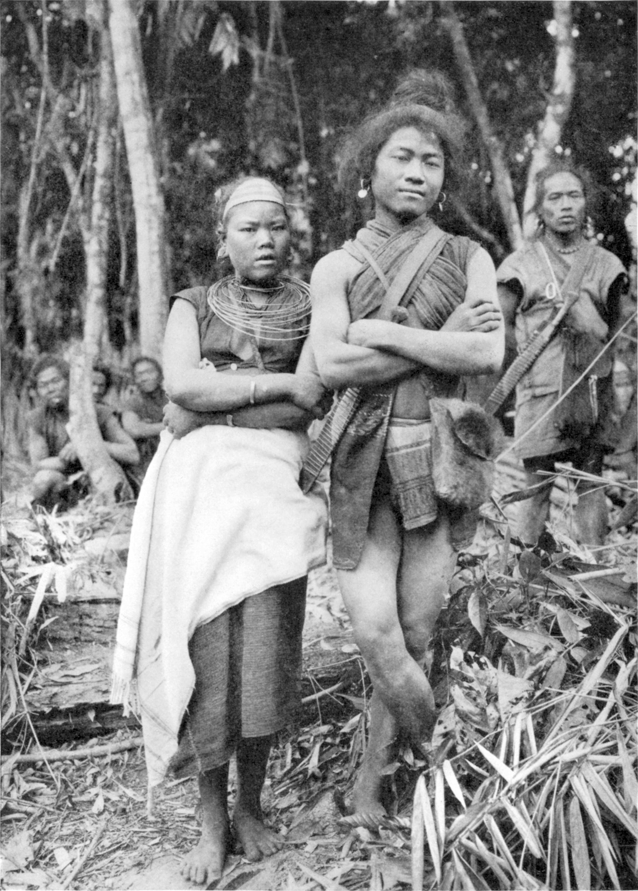
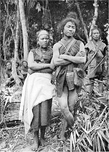 Minority peoples in Mishmi, Dibrugarh.
According to the 2011 census Dibrugarh district has a population of 1,327,748,[7] roughly equal to the nation of Mauritius[8] or the US state of Maine.[9] This gives it a ranking of 367th in India (out of a total of 640).[7] The district has a population density of 393 inhabitants per square kilometre (1,020 /sq mi) .[7] Its population growth rate over the decade 2001-2011 was 12.04 %.[7] Dibrugarh has a sex ratio of 952 females for every 1000 males,[7] and a literacy rate of 76.22 %.[7]
Hindus 1,075,878, Muslims 53,306 (4.5%), Christians 45,040. The main communities inhabiting the district includes Ahoms, Tea tribes, Sonowal Kacharis, Sutiya, Muttock, Moran etc. There are also some Tai speaking Buddhist communities like Tai-Phake, Khamti and Khamyang.
Language commonly used in the district are Assamese, English, Hindi and Bengali.
Flora and fauna
In 1999 Dibrugarh district became home to Dibru-Saikhowa National Park, which has an area of 340 km2 (131.3 sq mi).[10] It shares the park with Tinsukia district. It is also home to the Padumani-Bherjan-Borajan Wildlife Sanctuary, which was established in 1999 and has an area of 7.2 km2 (2.8 sq mi).[10]
Education
The district is the pivot of higher education in the entire North East India. Right from the British India period the district has been a center for learning. The Assam Medical College was established by a personal grant from Dr. John Berry White after he retired as the civil surgeon of Lakhimpur district. The medical school, "John Berry White Medical School" was set up in 1900 at Dibrugarh, and thus this premier institute started its history, and marked a new era in education.[11] Assam Medical College has the pride of having the first Radiology department in India, as in 1910 two X-Ray machine (One 10MA and another 15MA) was bought from England, only 15 years after the discovery of X-Rays by Professor Wilhelm Conrad Roentgen in 1895-96. These two were the first X-Ray machines in India.
Apart from medical, the other higher fields of learning in the district are Pharmacology, Geology and Applied Geology and Petroleum Technology. All these courses are offered by Dibrugarh University, which was established in the year 1965.
Beside the University, other centres for learning are:
- Dibrugarh Poly-technique (offering various diploma courses in Electrical, Civil and Mechanical fields).
- Regional Medical Research Centre -RMRC (a centre for scientific and research in Bio-medical sciences where major health problems and its causes are studied).
References
- ^ a b Law, Gwillim (2011-09-25). "Districts of India". Statoids. http://www.statoids.com/yin.html. Retrieved 2011-10-11.
- ^ Srivastava, Dayawanti et al. (ed.) (2010). "States and Union Territories: Assam: Government". India 2010: A Reference Annual (54th ed.). New Delhi, India: Additional Director General, Publications Division, Ministry of Information and Broadcasting (India), Government of India. pp. 1116. ISBN 978-81-230-1617-7.
- ^ "Island Directory Tables: Islands by Land Area". United Nations Environment Program. 1998-02-18. http://islands.unep.ch/Tiarea.htm. Retrieved 2011-10-11. "Vaygach Island 3,329"
- ^ "Oil India Limited :: A Navratna Company". Oil-india.com. http://www.oil-india.com/OOffices.aspx. Retrieved 2011-05-20.
- ^ "List of Assembly Constituencies showing their Revenue & Election District wise break - up". Chief Electoral Officer, Assam website. http://ceoassam.nic.in/Gen_Informations/2.1%20-%20DEOs%20wise%20ACs%20breakup.pdf. Retrieved 26 September 2011.
- ^ "List of Assembly Constituencies showing their Parliamentary Constituencies wise break - up". Chief Electoral Officer, Assam website. http://ceoassam.nic.in/Gen_Informations/2.2%20-%20PC-wise%20LAC%20breakup.pdf. Retrieved 26 September 2011.
- ^ a b c d e f "District Census 2011". Census2011.co.in. 2011. http://www.census2011.co.in/district.php. Retrieved 2011-09-30.
- ^ US Directorate of Intelligence. "Country Comparison:Population". https://www.cia.gov/library/publications/the-world-factbook/rankorder/2119rank.html. Retrieved 2011-10-01. "Mauritius 1,303,717 July 2011 est."
- ^ "2010 Resident Population Data". U. S. Census Bureau. http://2010.census.gov/2010census/data/apportionment-pop-text.php. Retrieved 2011-09-30. "Maine 1,328,361"
- ^ a b Indian Ministry of Forests and Environment. "Protected areas: Assam". http://oldwww.wii.gov.in/envis/envis_pa_network/index.htm. Retrieved September 25, 2011.
- ^ "Assam Medical College". http://www.assammedicalcollege.net/history.html. Retrieved 19 May 2011.
External links
- Government website
- Dibrugarh Wikitravel
- Assam Medical College
- Dibrugarh University
- Dibrugarh Online Website

Dhemaji district Lakhimpur district 
Tinsukia district  Dibrugarh district

Jorhat district Sibsagar district Tirap district, Arunachal Pradesh 27°28′27″N 94°55′05″E / 27.474161°N 94.918098°E
Categories:

Wikimedia Foundation. 2010.